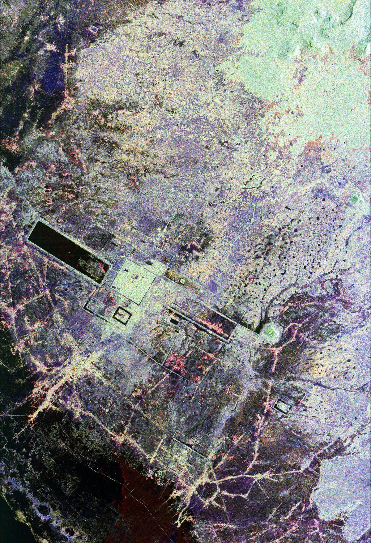
Angkor Seen From the Endeavor Satellite, April & October 1994
The short-lived satellite radar inspection campaigns over Angkor in 1994.

Published: 1994
SIR‑C/X‑SAR (Space-borne Imaging Radar‑C/X‑Band Synthetic Aperture Radar) was a joint mission of the United States, German and Italian space agencies. The Jet Propulsion Laboratory built and managed the Spaceborne Imaging Radar‑C portion of the mission for NASA’s Office of Mission to Planet Earth.
In 1994, the World Monument Fund and the Royal Angkor Foundation approached American space agency NASA about the possibility of observing Angkor from space. The aim was to gather data to allow better documentation and monitoring of Angkor, as well as allowing a reinterpretation of the origins and prehistory of the ancient city. NASA responded by taking a unique look at Angkor from the space shuttle Endeavor. To be able to see through the dense jungle that surrounds Angkor, astronauts used the Earth imaging system X‑SAR to study areas of cultural, natural and archaeological importance. The areas observed were mainly in Laos, Thailand, Vietnam and Cambodia, including the city of Angkor. The SIR‑C/X‑SAR was carried in the payload bay of the space shuttle which flew upside down, aiming the instrument at Earth. As Endeavour passed overhead, SIR‑C/X‑SAR transmitted a wide beam of microwave radiation to the Earth. Information like this is essential if scientists are to understand the Earth’s ecosystem, and the impact humans are having on it. The low power involved-penetrated cloud cover, vegetation, even sand, reflecting off more substantial structures such as rocks and buildings.
The reflected microwave radiation was recorded by the system which built up an image of a wide strip of land during each orbit. After a number of orbits the SIR‑C/X‑SAR covered the entire site being observed. The results of the 1994 flight were presented in April 1994 this year at a Radar Imaging and Cultural Resource Management symposium at the University of Florida.
Images from the international Space Radar Laboratory may help researchers find previously unknown settlements near the ancient city of Angkor in Cambodia. The radar data were obtained during the October 1994 flight of the space shuttle Endeavour, processed and then sent in January to the World Monuments Fund in New York City. The group had approached the radar science team about observing the Angkor area after the Space Radar Laboratory’s first flight in April 1994.
“I had read about the radar mission while the April mission was in progress and instantly surmised that it would have applications to the international research efforts at Angkor,” said John Stubbs, program director of the World Monuments Fund. “I didn’t really know where to start, but I was hopeful NASA would be willing to image the area around Angkor.”
The April 1994 flight of the Space Radar Laboratory’s complementary radars — the Spaceborne Imaging Radar‑C/X‑band Synthetic Aperture Radar (SIR‑C/X‑SAR) — first demonstrated their capability to obtain vast amounts of data that could be used to advance many disciplines, including ecological, oceanographic, geologic and agricultural investigations.
“We realized after the huge success of the first flight that we could be more flexible in adding new sites to the timeline of flight two,” said Dr. Diane Evans, the SIR‑C project scientist at NASA’s Jet Propulsion Laboratory. “Since our science team was interested in studying as much of the tropical rainforest as possible, Cambodia and the Angkor site complemented our ecology objectives.” “The ‘temple mountain’ monuments at Angkor, such as Angkor Wat and the Bayon, are not unlike some of the pyramid-like forms encountered in Central America,” Stubbs said. “The sheer size and sophistication of Angkor’s great city plan, now enveloped in dense jungle, set this ancient capital apart as the ultimate jungle ruin.”
(ref: 7 Fev. 1995 announcement, TSGC (Texas Space Grant Consortium))
According to Imran Vittachi (Phnom Penh Post, 19 Apr. 1996), “the advantage of radar imaging is that, unlike aerial and orbital photography, it does not have to rely on visible light to produce good pictures taken from different angles. It is especially difficult to carry out remote sensing on tropical areas using older technologies, say scientists, as monsoon rains often leave vast areas obscured by clouds. Although the radioactive signals work best on arid landscapes — where they can penetrateto depths of five meters — they nevertheless can expose subtle disturbances in the topography and foliage which have not been spotted before. So far the use of radar-imagery labs has led to the discovery of the ancient desert city of Ubar in Oman, and silk road outposts in China’s northwestern reaches. In Cambodia, the use of radar sensors has already led to the detection of 68 prehistoric mounds near Ak-yum and Roluos. Archaeologists suspect these may date as far back as 5000BC. “Angkor seen from the air is defined by water features which are highly reflective of radar energy,” says Dr. Elizabeth H. Moore, researcher at the School of Oriental and African Studies in London. “The importance of water to the Khmer, and the sensitivity of radar for mapping the hydraulic landscape, make the NASA SIR‑C/X‑SAR an ideal remote sensing tool for Angkor.”
Read also ‘From the Viewpoint of the Gods’
(by Geoff McNamara, Angkor in-flight magazine, Jan-March 1997 | digitized by the Queen Mother Library, Phnom Penh)
The hi-resolution photography comes from the Center for Space Study, Austin, Texas, USA. Online archive from the center are available only up to year 2015 so far (Sept. 2022).
Tags: space, satellite radar, imaging, Angkor site, World Monument Fund
