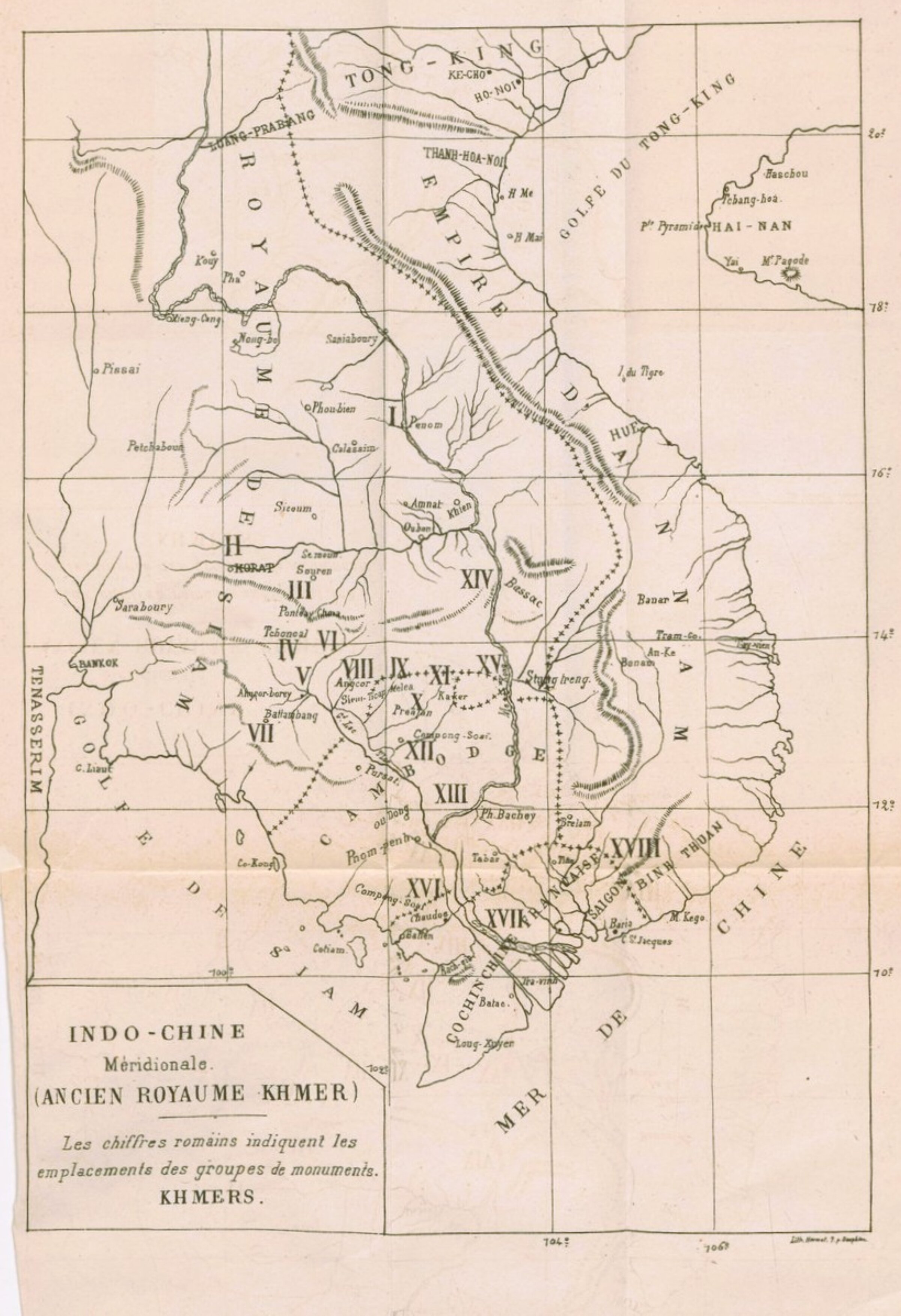
Maps & Plans
Building an online collection of maps related to Angkor, Khmer and Southeast Asia civilizations.
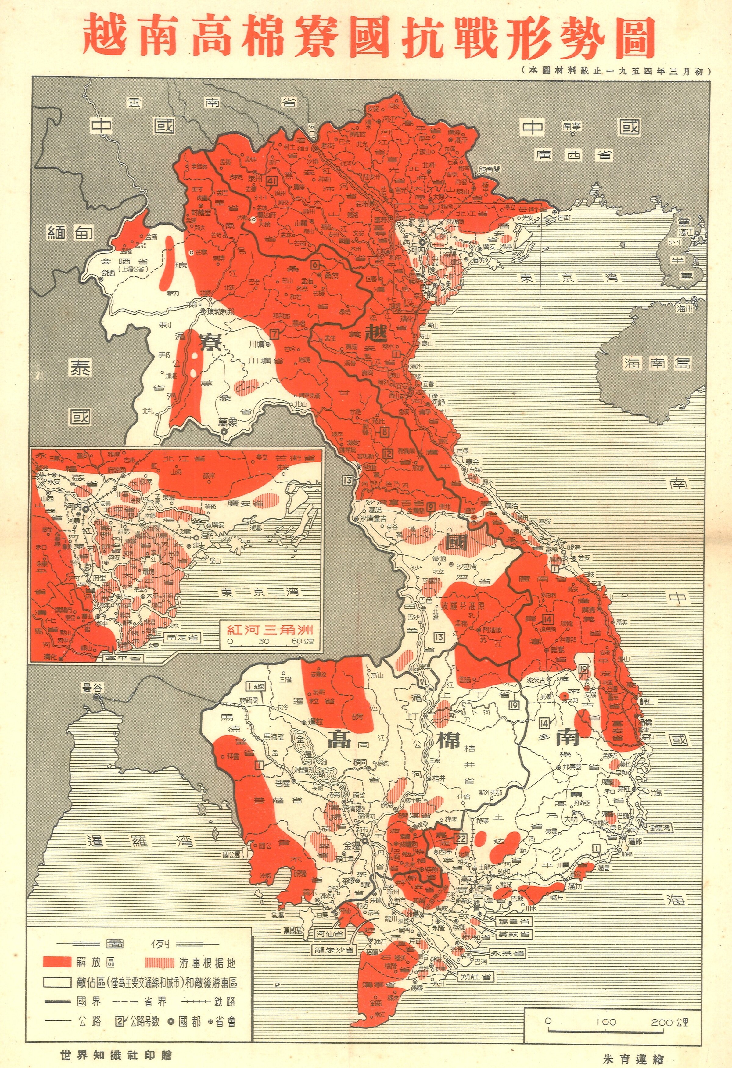
越南高棉寮國抗戰形勢圖 [Situation Wartime Map of Vietnam, Khmer and Laos], Beijing, 1954
越南高棉寮國抗戰形勢圖 [Situation Wartime Map of Vietnam, Khmer and Laos]. 世界知識社 , 北京. [Reference Unit, World Knowledge Society Publishing, Beijing], last updated March 1954. Illustration by 朱育蓮繪 [Zhu Yulin]. Scale 1:10,000,000. Showing 1) 解放區 : "Liberated Zones" [solid red] 2) 游軎根据地 : "Resistance Base Are" [red lines] 3) 敵佔區(僅為主要交通線和城市)和敵後游惠區 : "Enemy-Occupied Area (Main Transportation Lines and Cities Only) and You Hui Area Behind Enemy Lines" [white]. Inset 磅海省 ["Red River Delta"], scale 1:3,000,000, with an updated military field situation in the Hanoi region. 36.9 x 25cm.
[ADB note: Interestingly, the title mentions "抗戰", "War of Resistance", a term historically used to refer to the fight against the Japanese occupation of mainland China in the 1920s and 1930s.]
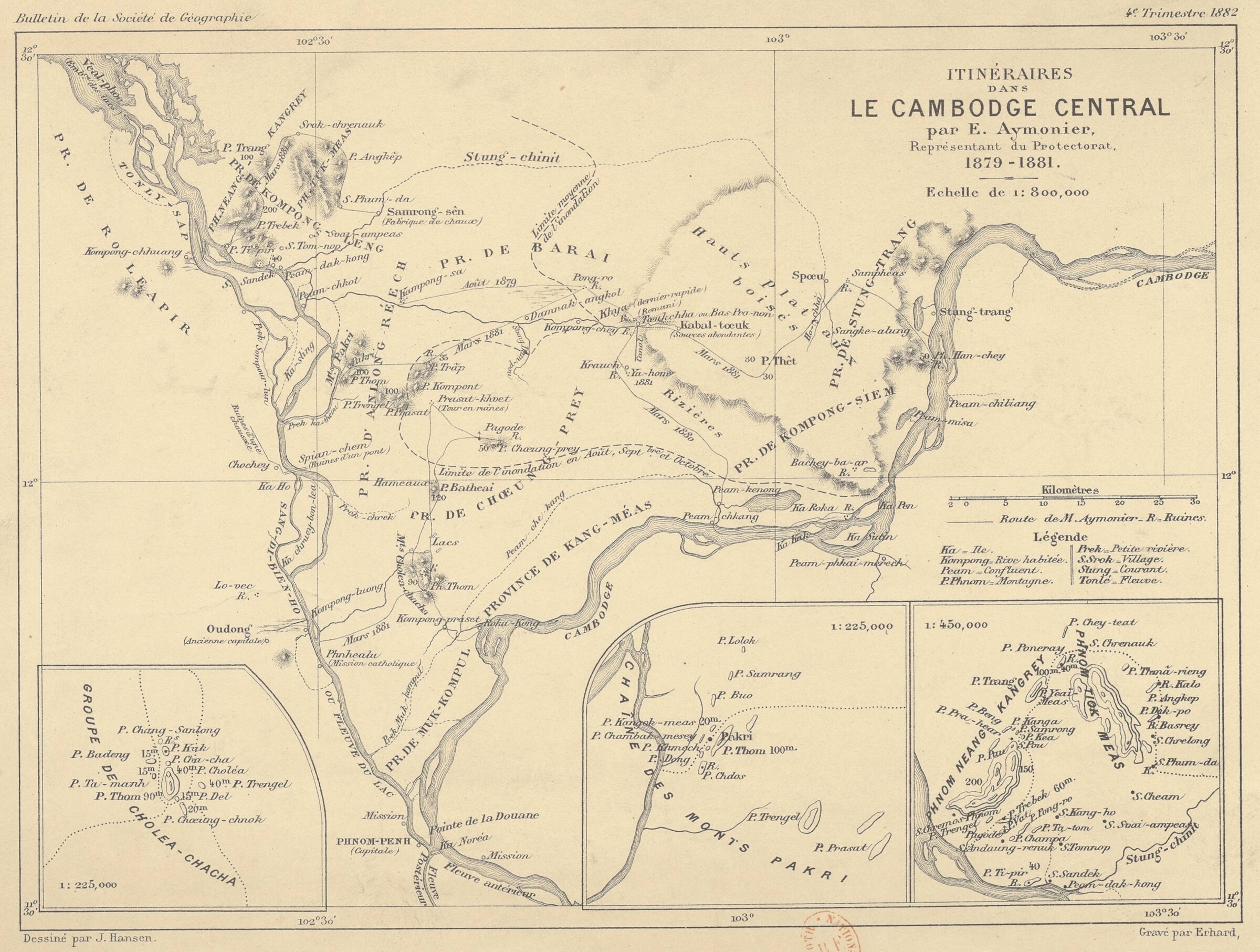
Aymonier itineraires cambodge central 1879 1881 map hr
Etienne Aymonier's Itineraries in Central Cambodia as French Protectorate Representative between 1879 and 1881. Scale 1: 800,000. [from Bulletin de la Société de Géographie de Paris, Oct. 1882.]
Etienne Aymonier's Itineraries in Central Cambodia as French Protectorate Representative between 1879 and 1881. Scale 1: 800,000. [from Bulletin de la Société de Géographie de Paris, Oct. 1882.]
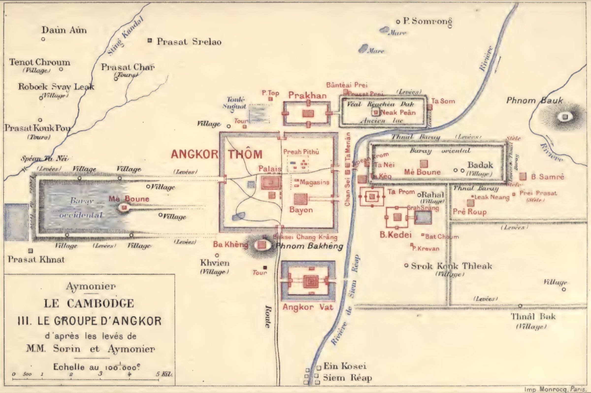
Aymonier-Sorin, Le Groupe d'Angkor [Angkor Group]
Drafted from topographic studies by Etienne Aymonier and Commandant P. Sorin, c. 1900 [in Le Cambodge III, 1904]
Drafted from topographic studies by Etienne Aymonier and Commandant P. Sorin, c. 1900 [in Le Cambodge III, 1904]
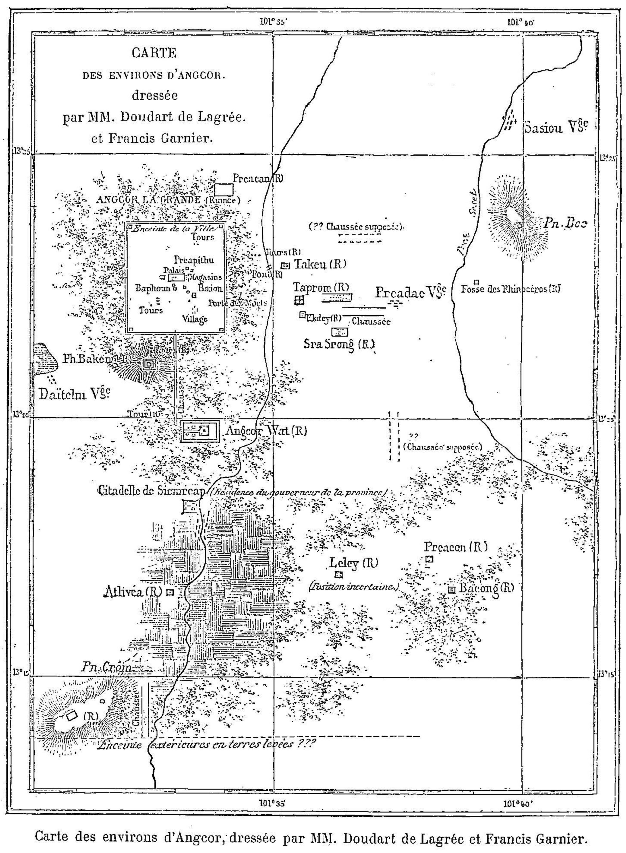
Angkor Area Map by Doudart de Lagree and F. Garnier
Map of "Environs d'Angkor" [Angkor Area] [in Francis Garnier, Voyage d'exploration en Indochine, 1885, p 11].
Map of "Environs d'Angkor" [Angkor Area] [in Francis Garnier, Voyage d'exploration en Indochine, 1885, p 11].
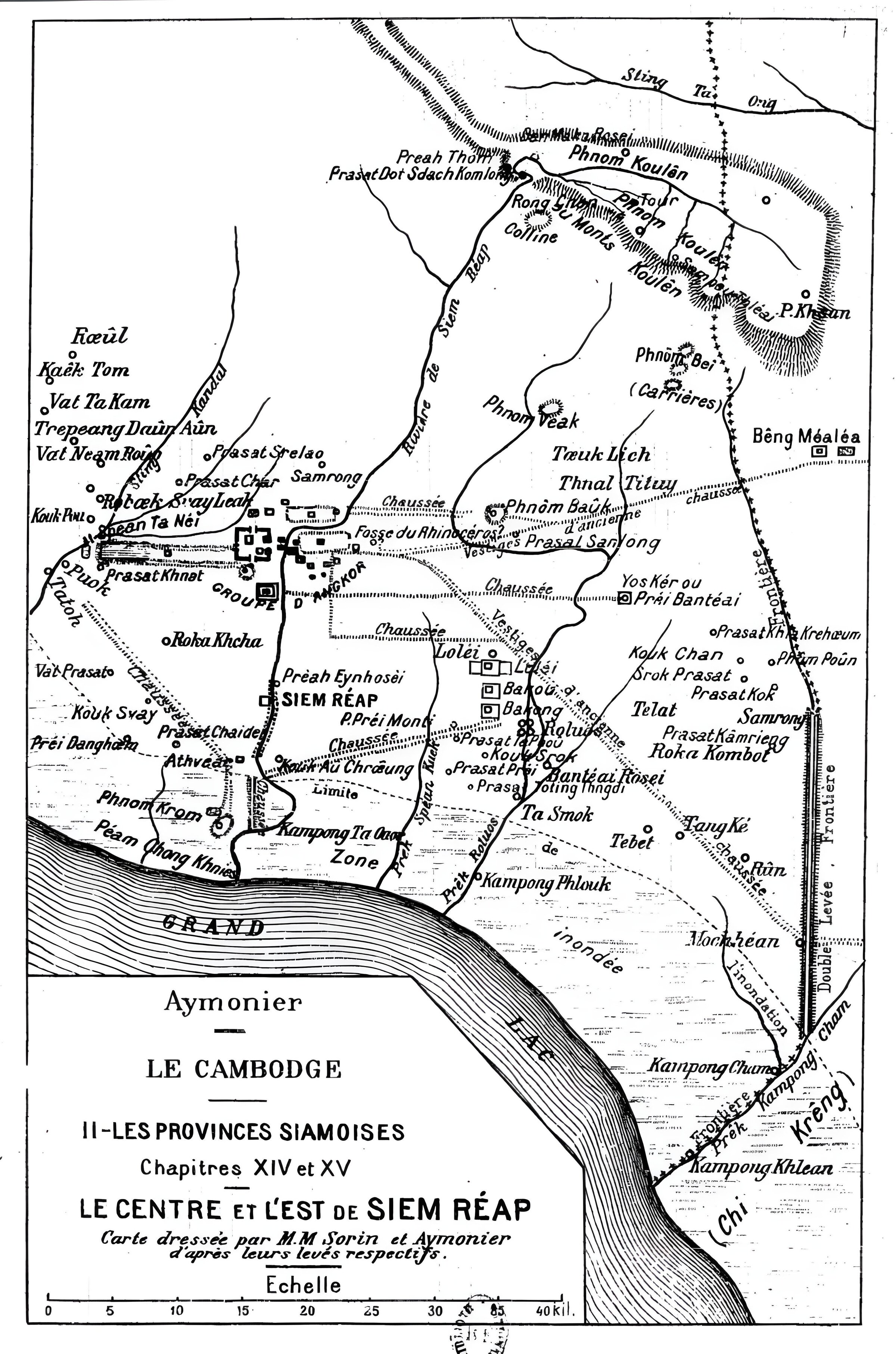
Siem Reap Area (East and Center) by Aymonier
Map of Siem Reap East and Center, by Sorin and Aymonier, in Etienne Aymonier, Le Cambodge II, Les provinces siamoises, Paris, 1901, chapt. XIV and XV.
Map of Siem Reap East and Center, by Sorin and Aymonier, in Etienne Aymonier, Le Cambodge II, Les provinces siamoises, Paris, 1901, chapt. XIV and XV.
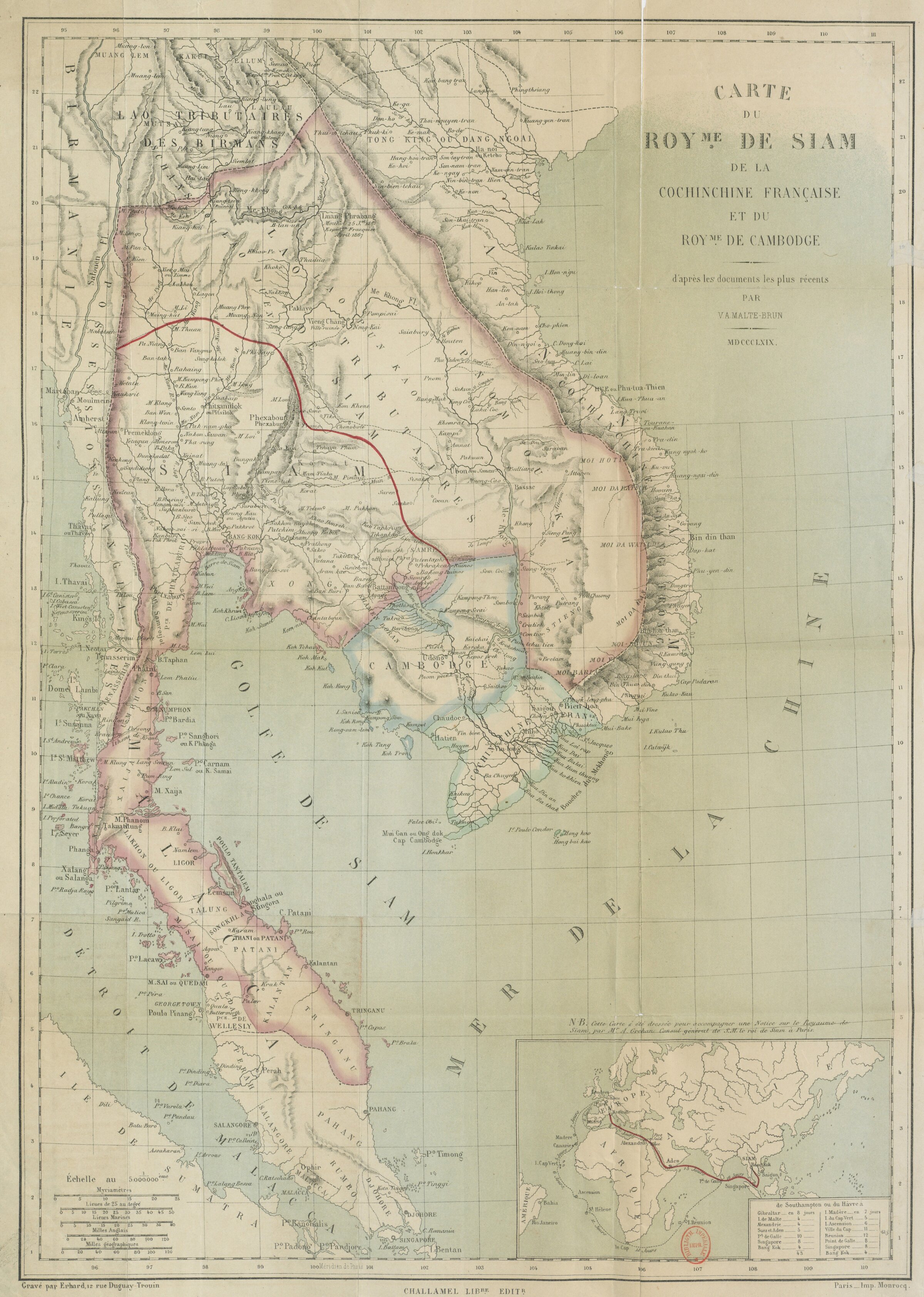
Carte du Royaume de Siam, de la Cochinchine Francaise et du Royaume du Cambodge [Map of the Kingdom of Siam, French Cochinchina and the Kingdom of Cambodia]
From Amédée Gréhan (1808-1879), Notice sur le royaume de Siam publiée par M. A. Gréhan, Paris, Imp. Simon Raçon & Co., 1867. [A. Gréhan signed: 'Phra Siam Duranuraks, Consul de Sa Majesté le Suprême Roi de Siam et son commissaire général près l'Exposition Universelle' ['Phra Siam Duranuraks, Consul of His Majesty the Supreme King of Siam and his Commissioner General to the Universal Exposition'].
From Amédée Gréhan (1808-1879), Notice sur le royaume de Siam publiée par M. A. Gréhan, Paris, Imp. Simon Raçon & Co., 1867. [A. Gréhan signed: 'Phra Siam Duranuraks, Consul de Sa Majesté le Suprême Roi de Siam et son commissaire général près l'Exposition Universelle' ['Phra Siam Duranuraks, Consul of His Majesty the Supreme King of Siam and his Commissioner General to the Universal Exposition'].
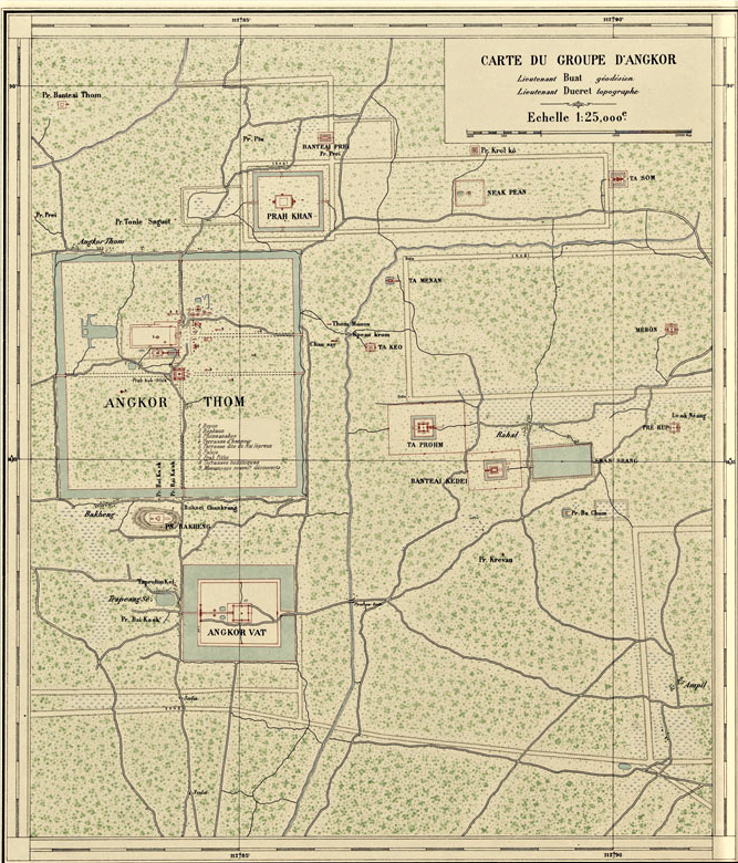
Carte du Groupe d'Angkor, EFEO [First map of Angkor Group issued by EFEO in 1909], topography by Lieutenant Ducret
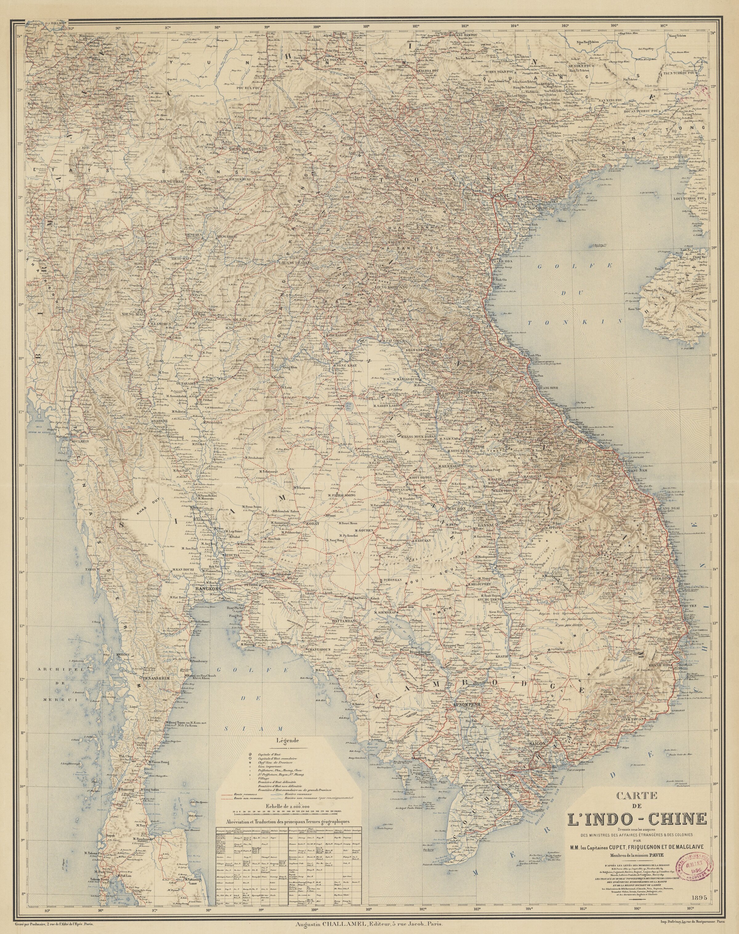
Carte de l'Indo-Chine (Mission Pavie)
'Carte de l'Indo-Chine dressée sous les auspices des ministres des Affaires étrangères et des Colonies par MM. les Capitaines Cupet, Friquegon et de Malglaive, membres de la Mission Pavie, d'après - les levés des membres de la mission: MM. Pavie 1880-91, Cupet 1887-91, Nicolon 1887-89, de Malglaive, Cogniard, Rivière, Dugast, Lugan 1890-91, Counillon 1890, Massie, Lefevre-Pontalis, de Coulgeans, Macey 1891; - Les travaux du bureau topographique des troupes de l'Indo-Chine; - des ingénieurs hydrographes de la Marine ; - et de la mission Doudart de Lagrée; - les itinéraires de MM Harmand, d'Amade, Neis, Septans, Humann, Trumelet-Faber, Yersin, Garnier, Delingette, etc.; - et les documents Anglais et Siamois' ['Map of Indochina drawn up under the auspices of the Ministers of Foreign Affairs and Colonies by Captains Cupet, Friquegon and de Malglaive, members of the Pavie Mission, based on - The surveys of the Mission's members: Messrs. Pavie 1880-91, Cupet 1887-91, Nicolon 1887-89, de Malglaive, Cogniard, Rivière, Dugast, Lugan 1890-91, Counillon 1890, Massie, Lefevre-Pontalis, de Coulgeans, Macey 1891; - The work of the Military Topographical Office in Indochina; - The hydrographic engineers of the Navy; - and The Doudart de Lagrée mission; - The itineraries of Messrs. Harmand, d'Amade, Neis, Septans, Humann, Trumelet-Faber, Yersin, Garnier, Delingette, etc.; - and English and Siamese documents', Paris, Augustin Challamel, 1895.
'Carte de l'Indo-Chine dressée sous les auspices des ministres des Affaires étrangères et des Colonies par MM. les Capitaines Cupet, Friquegon et de Malglaive, membres de la Mission Pavie, d'après - les levés des membres de la mission: MM. Pavie 1880-91, Cupet 1887-91, Nicolon 1887-89, de Malglaive, Cogniard, Rivière, Dugast, Lugan 1890-91, Counillon 1890, Massie, Lefevre-Pontalis, de Coulgeans, Macey 1891; - Les travaux du bureau topographique des troupes de l'Indo-Chine; - des ingénieurs hydrographes de la Marine ; - et de la mission Doudart de Lagrée; - les itinéraires de MM Harmand, d'Amade, Neis, Septans, Humann, Trumelet-Faber, Yersin, Garnier, Delingette, etc.; - et les documents Anglais et Siamois' ['Map of Indochina drawn up under the auspices of the Ministers of Foreign Affairs and Colonies by Captains Cupet, Friquegon and de Malglaive, members of the Pavie Mission, based on - The surveys of the Mission's members: Messrs. Pavie 1880-91, Cupet 1887-91, Nicolon 1887-89, de Malglaive, Cogniard, Rivière, Dugast, Lugan 1890-91, Counillon 1890, Massie, Lefevre-Pontalis, de Coulgeans, Macey 1891; - The work of the Military Topographical Office in Indochina; - The hydrographic engineers of the Navy; - and The Doudart de Lagrée mission; - The itineraries of Messrs. Harmand, d'Amade, Neis, Septans, Humann, Trumelet-Faber, Yersin, Garnier, Delingette, etc.; - and English and Siamese documents', Paris, Augustin Challamel, 1895.
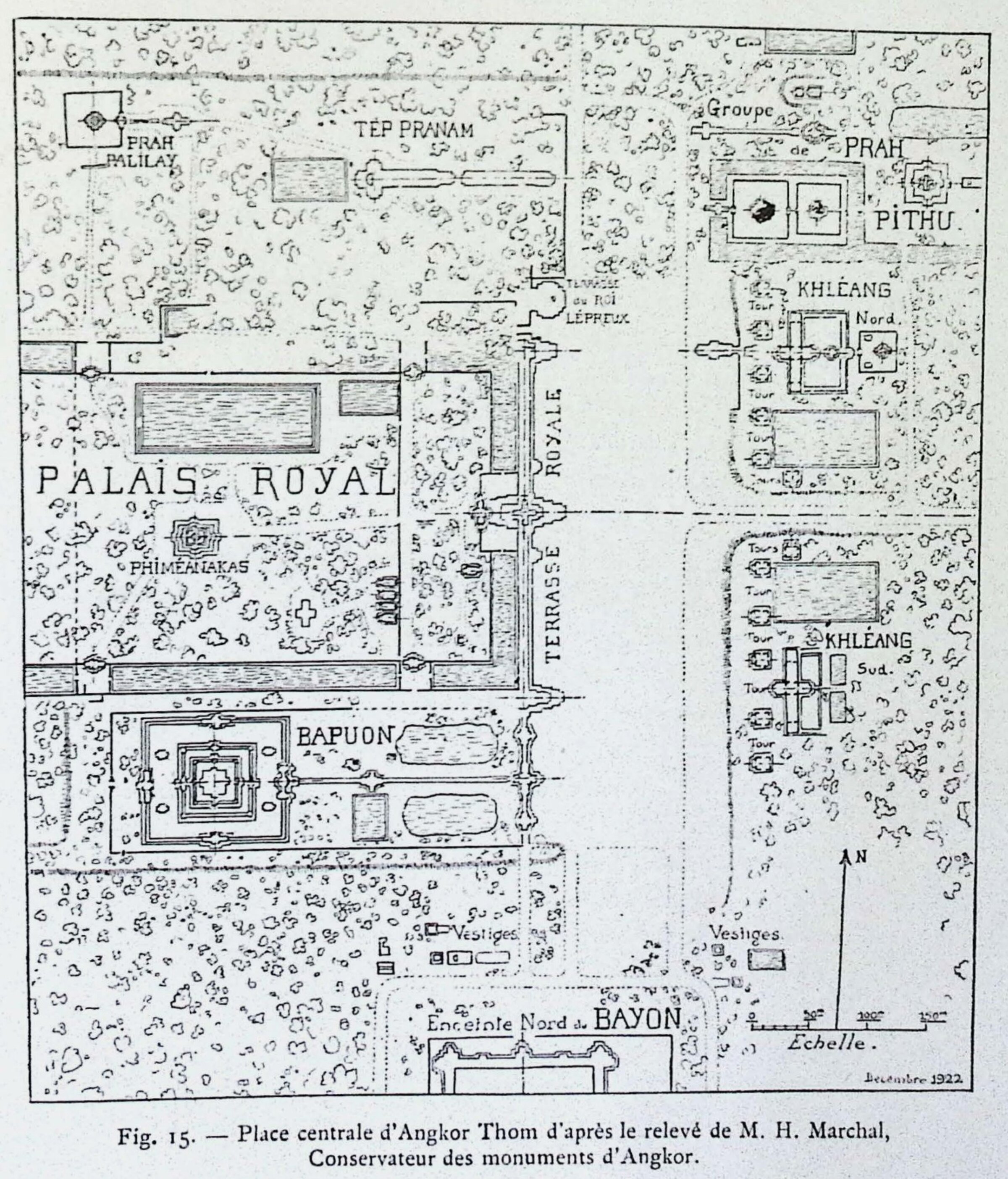
Angkor Thom Esplanade
From George Groslier, Angkor, 1931. After Henri Marchal's map.
From George Groslier, Angkor, 1931. After Henri Marchal's map.
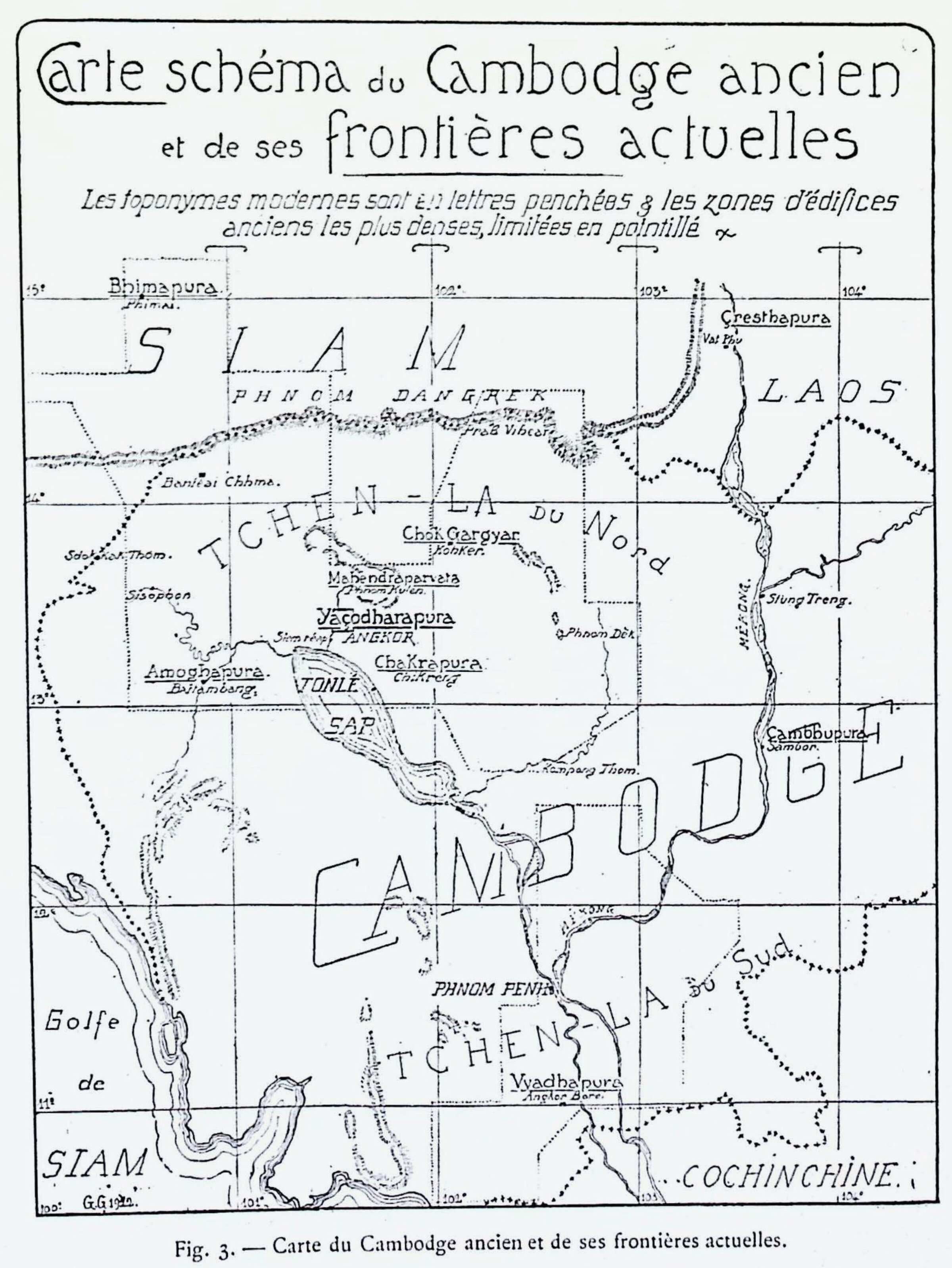
Schematic Map of Ancient Cambodia
From George Groslier, Angkor, 1931. Note the use of 'Chenla of the North' and 'Chenla of the South' - also 'Chenla of Land' and 'Chenla of Water' in other publications of that time -, a terminology that has since been contested.
From George Groslier, Angkor, 1931. Note the use of 'Chenla of the North' and 'Chenla of the South' - also 'Chenla of Land' and 'Chenla of Water' in other publications of that time -, a terminology that has since been contested.
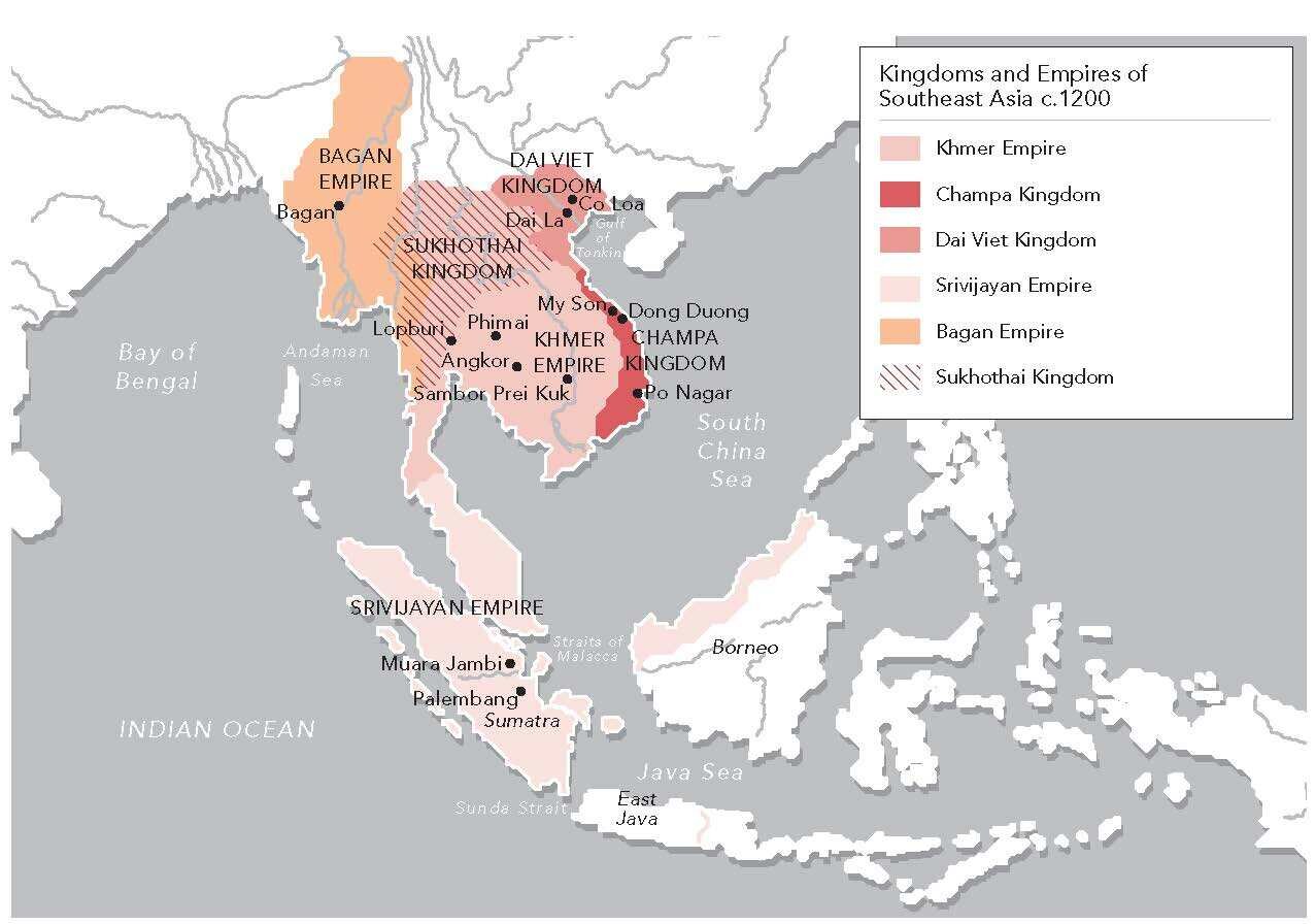
Kingdoms and Empires of Southeast Asia ca 1200
from Swati Chemburkar, Khmer Empire and Southeast Asia, 800-1450.
from Swati Chemburkar, Khmer Empire and Southeast Asia, 800-1450.
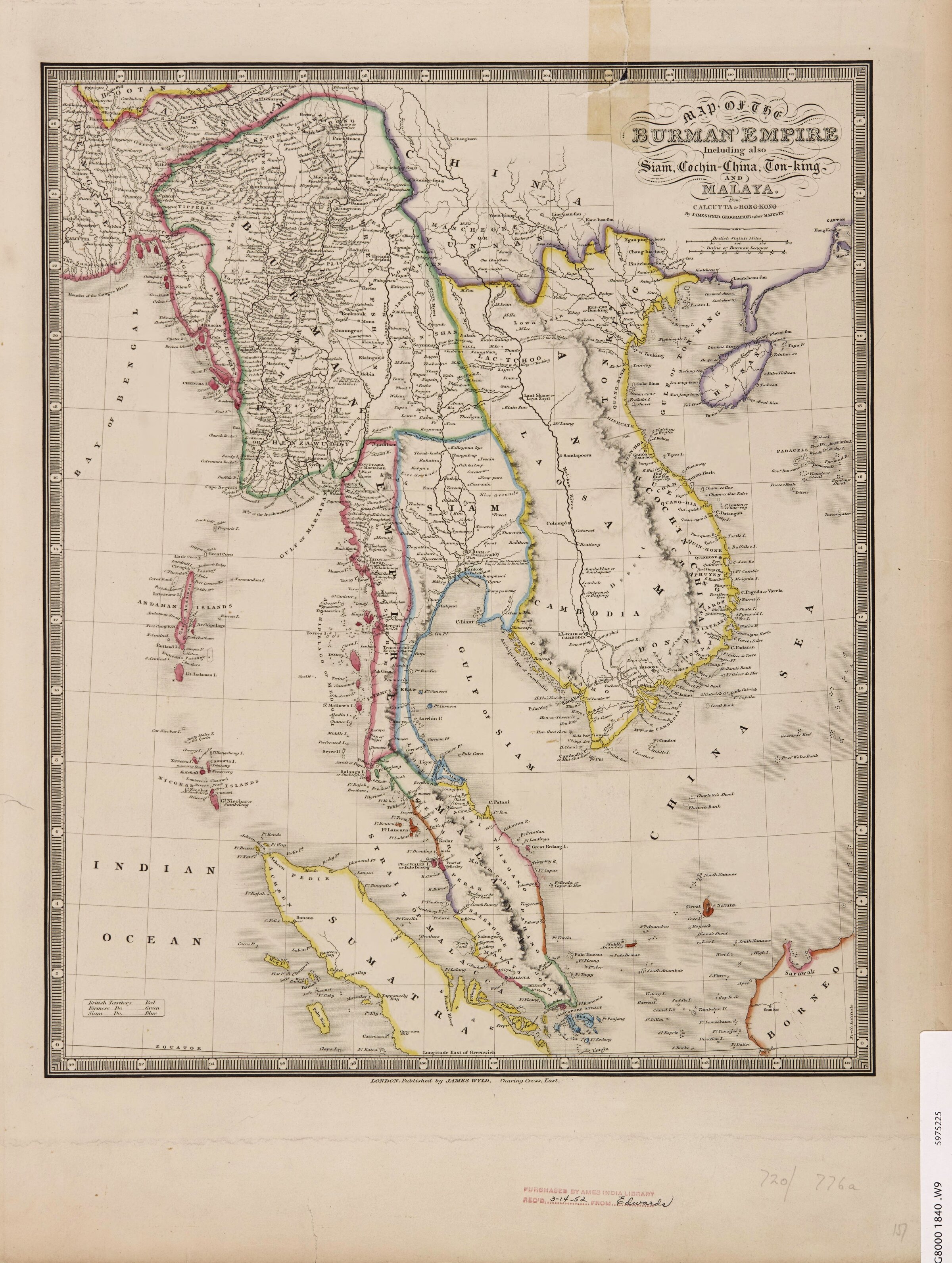
Burman Empire, with also Siam, Cochin-China, Ton-King and Malaya
Map of the Burman Empire with Siam, Cochinchina, Cambodia, Tonkin, Annam, Malaya, by James Wyld, Geographer to Her Majesty. c. 1842.
Map of the Burman Empire with Siam, Cochinchina, Cambodia, Tonkin, Annam, Malaya, by James Wyld, Geographer to Her Majesty. c. 1842.
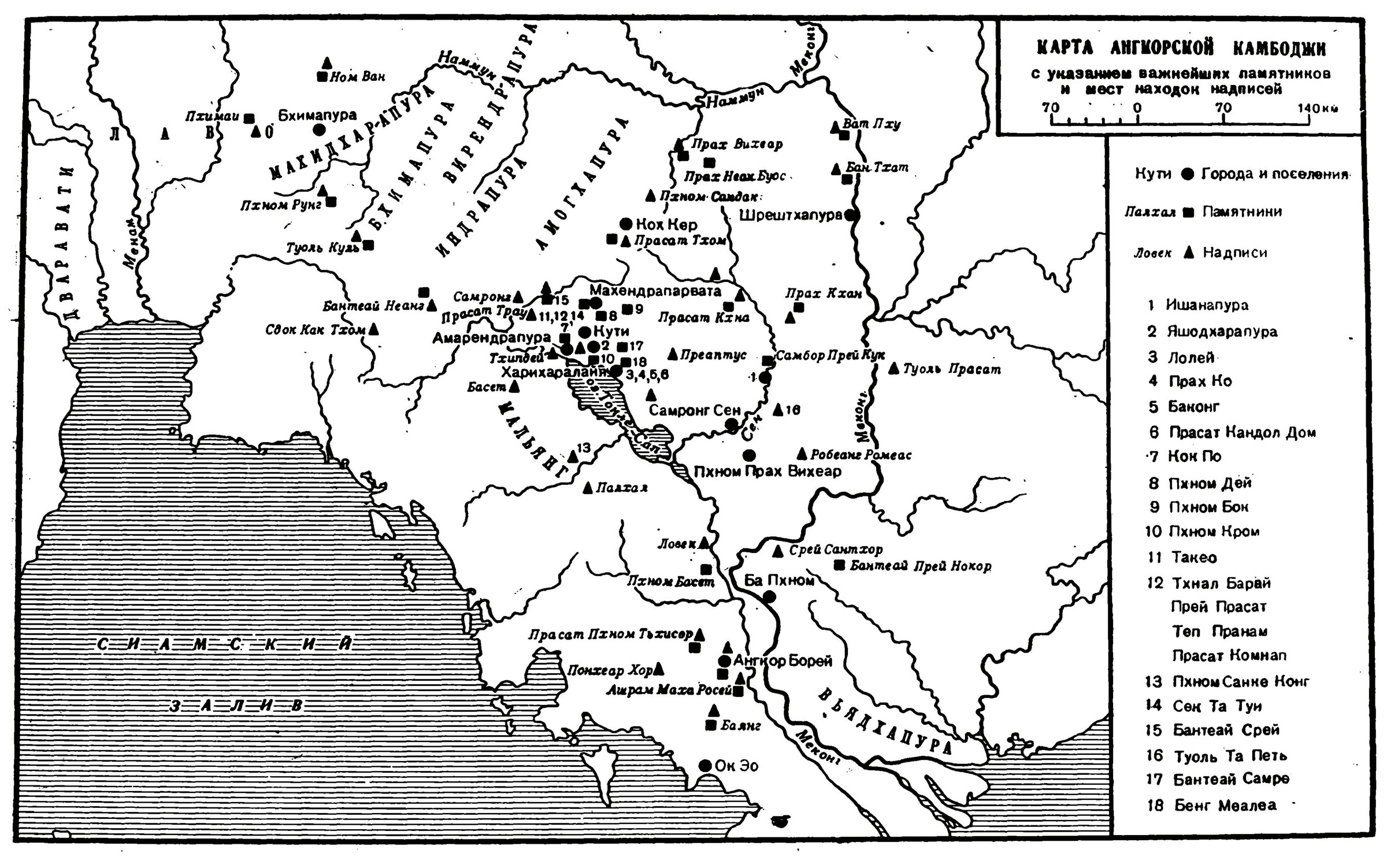
Sedov, Angkorskaya Imperia, 1967: Map of Angkorian Cambodia
showing the most important monuments and locations where inscriptions were found (in Russian) [Sedov 1967, p 251]
showing the most important monuments and locations where inscriptions were found (in Russian) [Sedov 1967, p 251]
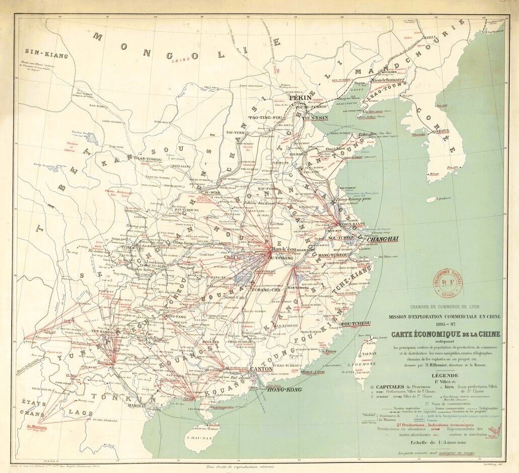
Economic Map of China, 1898
by H. Brenier, in Mission lyonnaise d'exploration economique de la Chine, Lyon, 1898.
by H. Brenier, in Mission lyonnaise d'exploration economique de la Chine, Lyon, 1898.
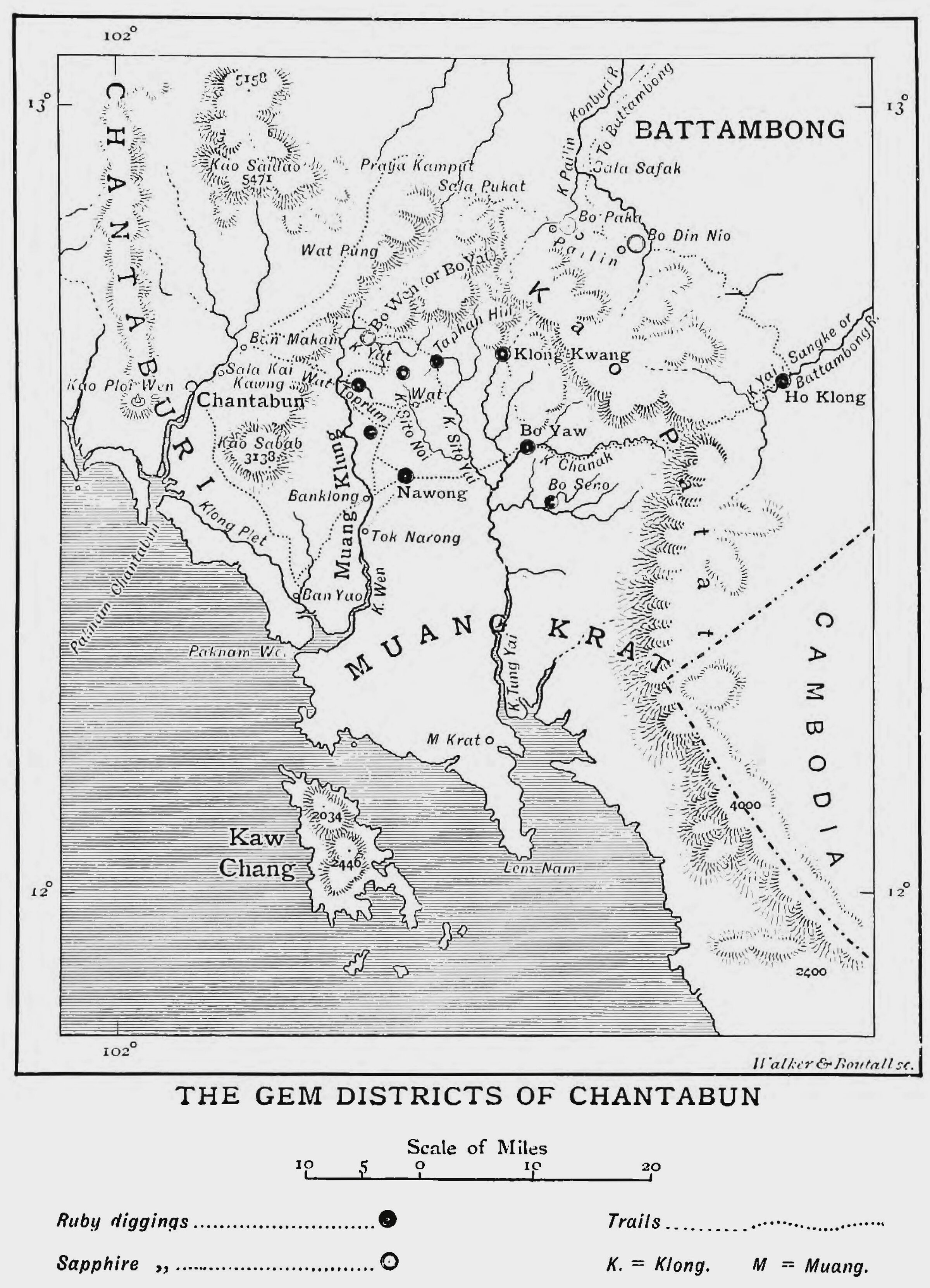
H. Warington-Smyth, The Gem Districts of Chantabun
'Chart of the Gems Districts of Chantabun', by H. Warington Smyth, ca. 1896. [source: Travels in Siam, vol. II, p. 179]
'Chart of the Gems Districts of Chantabun', by H. Warington Smyth, ca. 1896. [source: Travels in Siam, vol. II, p. 179]
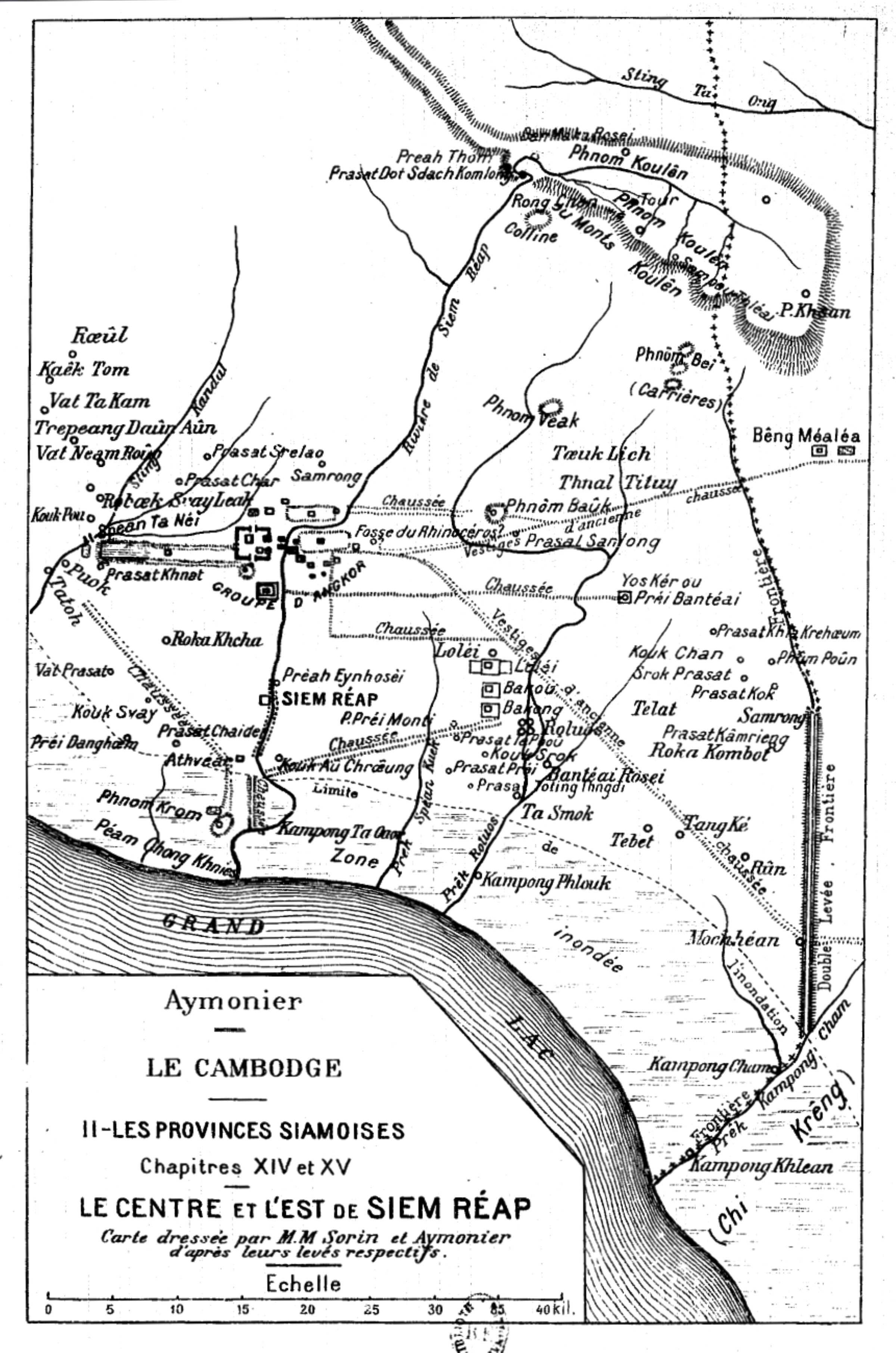
Center and East of Siem Reap Province, 1910.
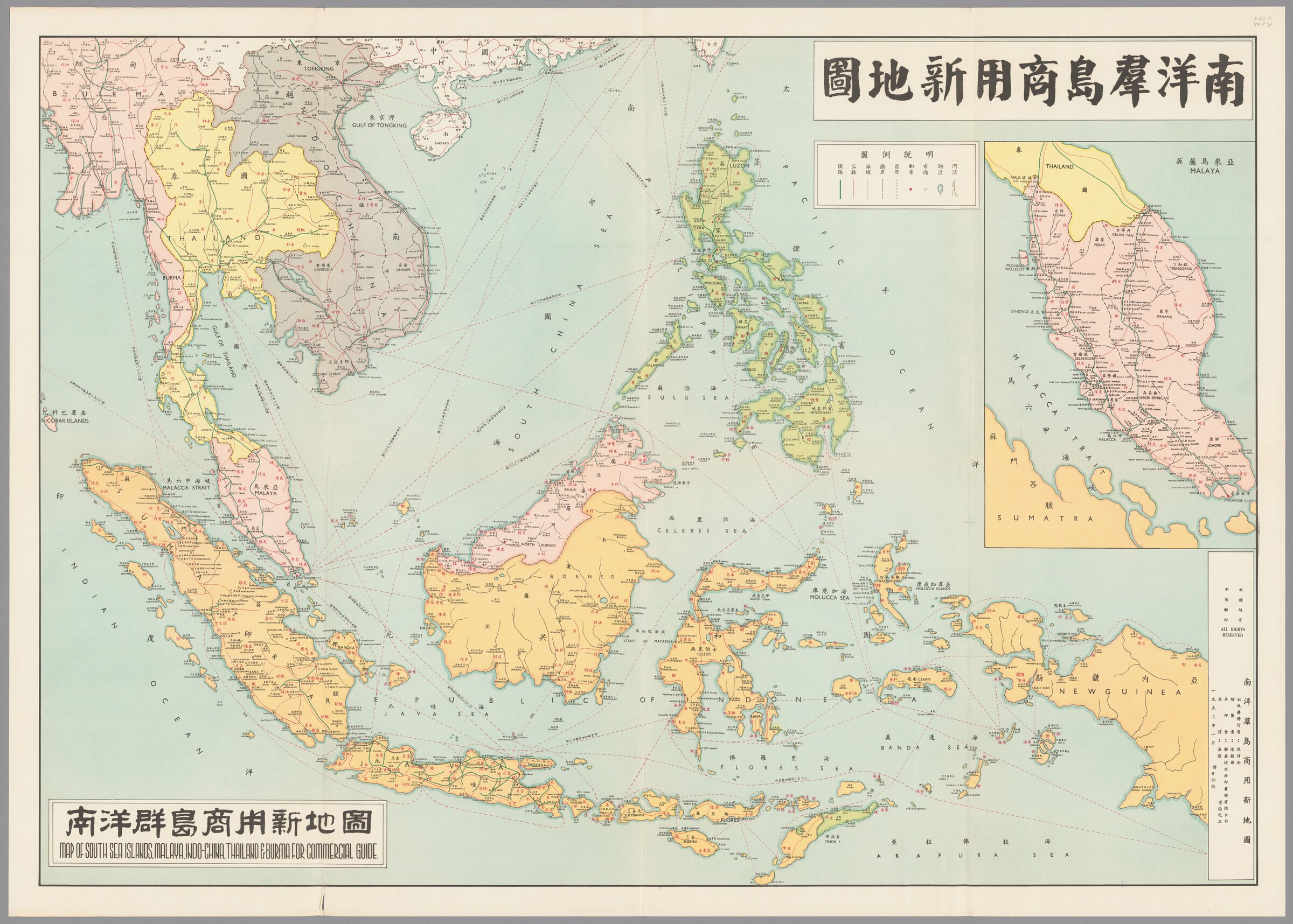
Commercial Map by Chen Weibin, Singapore, 1953.
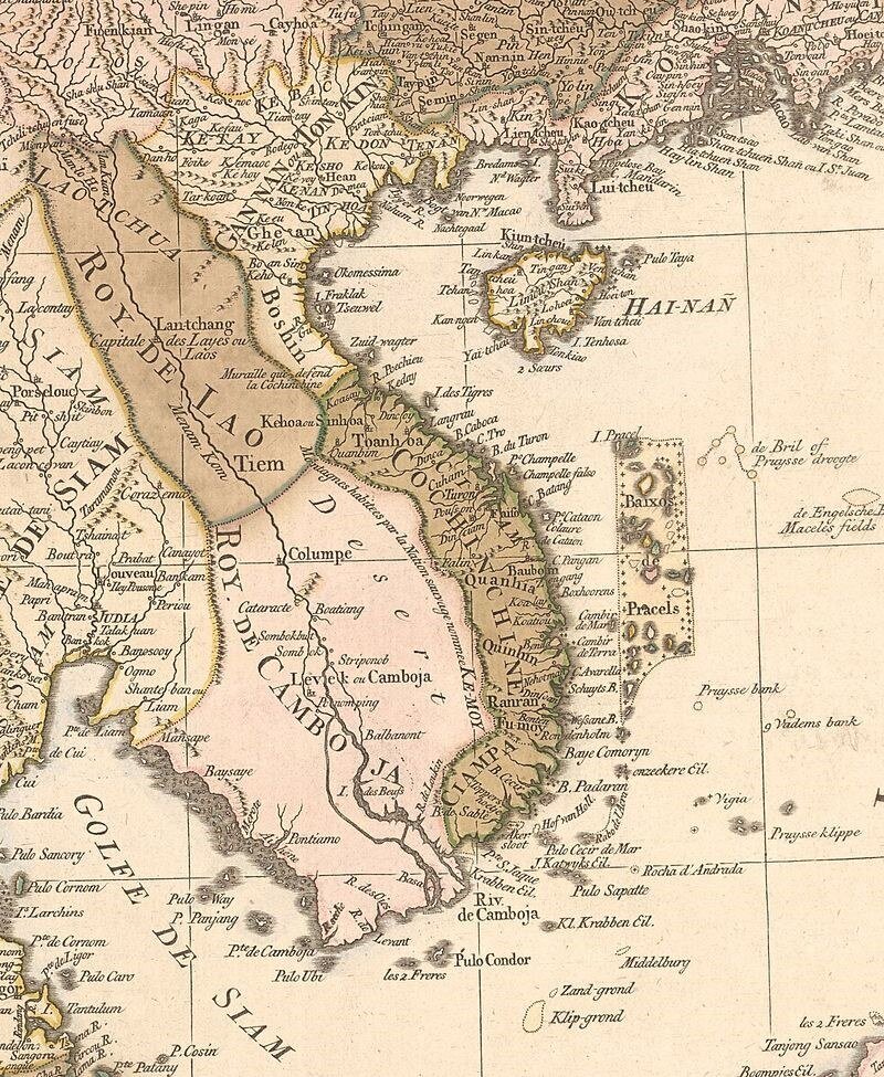
Dutch Map circa 1700
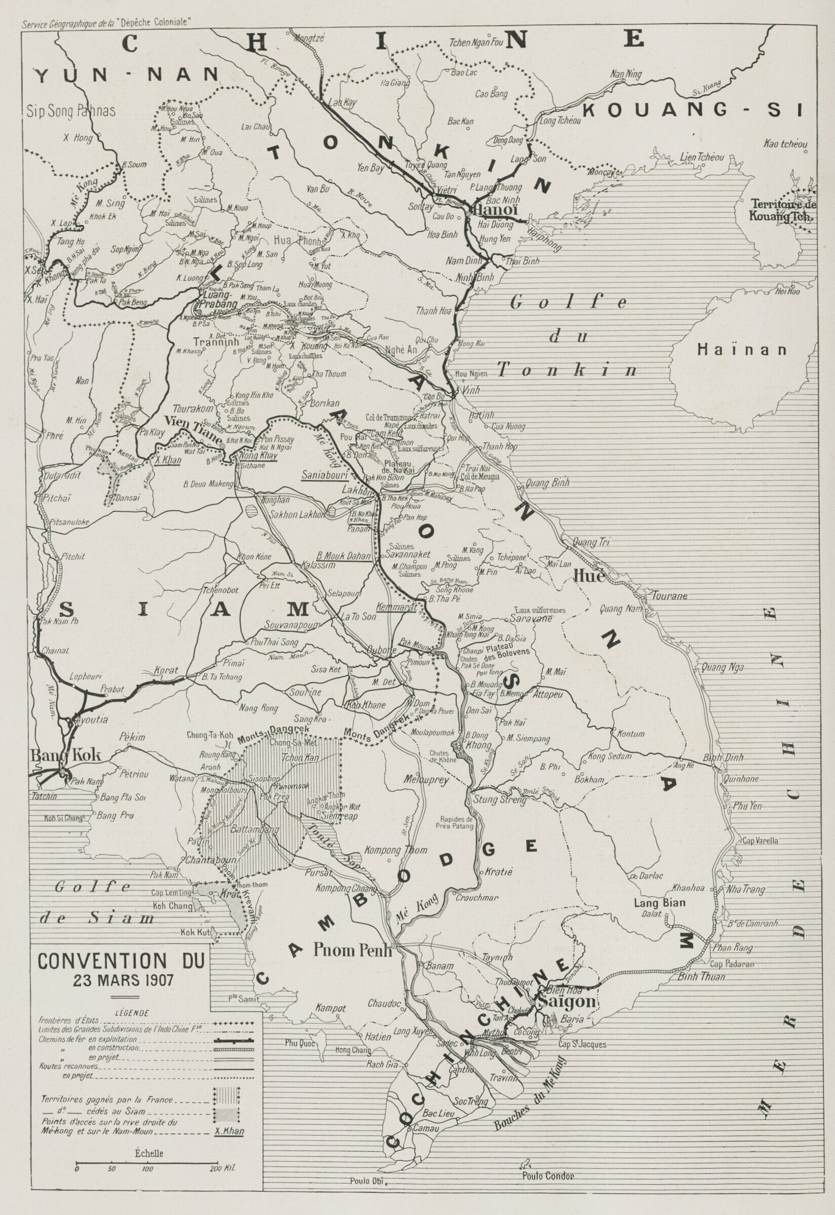
Official Map attached to the 1907 Siam-France Treaty