Circular Sites at Angkor: A Radar Scattering Model
by Elizabeth H. Moore
Eleven circular sites analyzed with pre-Lidar technology in Angkor area show similarities with building techniques used in Ancient Northern Thailand.

- Publication
- Journal of The Siam Society Vol 85, Parts 1 & 2, pp 107-119.
- Published
- 1998
- Author
- Elizabeth H. Moore
- Pages
- 12
pdf 1.4 MB
‘The succession of royal structures at Angkor are often presented as the height of Khmer culture and innovation. However, in the earlier transition from village to city, change was equally if not more radical’, note the author in preamble.
‘All of the eleven sites where curvilinear patterns were studied are circular mounds; some are inhabited; all are rural. Their west-east distribution extends some 30 km, from Phum Reul and Lovea on the west to Phum Stung on the west. The most northerly site, Mokak, is 15 km north of Phum Reul. These circular mounds are comparable to sites in Northeast Thailand. The curvilinear patterns visible on images generated from the radar data are similar in form to moats and earthworks which surround the mounds in Northeast Thailand. With some exceptions, the moats of the Angkor sites are vestigial, not typically apparent on the ground, nor visible on optical imagery.’
About the technology
The radar data was acquired with equipment of the National Aeronautics and Space Administration and the Jet Propulsion Laboratory, Pasadena, USA (Anthony Freeman, from the JPL, contributed to the paper): ‘A three-component scattering model is used to assess the presence of water at mound sites. Archaeological applications of the NASA/JPL radar have principally been conducted in arid regions. These have detected earlier man-made linear features (e.g. roads at Ubar and along the Silk Road), or climatic changes affecting habitation (such as desiccated subsurface water channels in the Safsaf Egyptian desert). Subsurface detection relies on an absence of ground level moisture and vegetation, allowing shorter and long~r wavelengths (X‑Band [3 em], CBand [6 em], L‑Band [23 em]) to sense variations in the soil’s dielectric constant which may be characteristic of former river beds. At Angkor, stratigraphic interpretation is not completely precluded, as the radar backscatter presents hydrological patterns of different chronological periods. However, the greatest potential is the discrimination of surface variations resulting from the radar’s sensitivity to moisture and vegetation.’
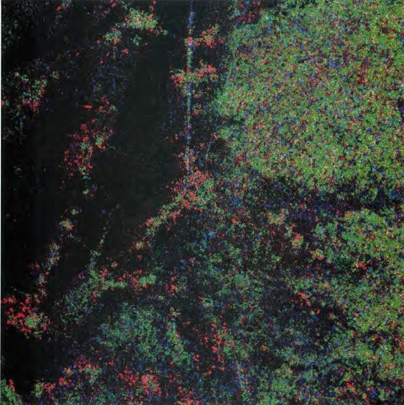
Photo: L‑Band scattering model image of Lovea-Phum Reul area.
Tags: mounds, roads, radar, prehistory, archaeology, moats, earthworks
About the Author

Elizabeth H. Moore
Emeritus Professor, Department of History of Art and Archaeology, School of Arts, University of London, Elizabeth H. Moore (1948, Washington DC, USA — 13 jan 2024, London) has extensively published on the archaeology of Myanmar, Thailand and Cambodia.
After her retirement, she moved to Yangon, Myanmar, bringing with her her personal library to which she gave access to Burmese students, but had to leave the country after the military coup, returning to London where she passed aawy after struggling with cancer.
Selected Publications
- The Pyu Landscape: collected articles. Myanmar: Ministry of Culture.
- ‘Urban Forms and Civic Space in Nineteenth to Early Twentieth Century Bangkok and Rangoon’. Journal of Urban History, (40) 1, 2011, pp 158 – 177.
- ‘Archaeology of the Shan Plateau, the Bronze to Buddhist Transition’. Contemporary Buddhism, 2009, (10) 10, pp 83 – 102. 2007.
- ‘Angkor Water Management, Radar Imaging, and the Emergence of Urban Centres in Northern Cambodia’. The Journal of Sophia Asian Studies, (18), pp 39 – 51, 2000.
- ‘The Gold Coast: Suvannabhumi? Lower Myanmar Walled Sites of the First Millennium A.D.’(with Win, San), Asian Perspectives, (46) 1, 2007, pp 202 – 232.
- ‘Interpreting Pyu material culture: Royal chronologies and finger-marked bricks’. Myanmar Historical Research Journal, (13), 2004, pp 1 – 57.
- ‘Myanmar Inscriptions Found at Angkor’ (Than Swe, H.E. and Sokrithy, Im and Moore, Elizabeth (2015). In: Tan, Noël Hidalgo, (ed.), Advancing Southeast Asian Archaeology 2013. Bangkok: SEAMEO-SPAFA, pp 15 – 17.
- ‘Spaceborne and Airborne Radar at Angkor: Introducing new technology to the ancient site’. In: Wiseman, James and El-Baz, Farouk, (eds.), Remote Sensing in Archaeology. New York: Springer, 2007, pp 185 – 216.
- ‘Astrology in Burmese Buddhist culture, Decoding an illustrated manuscript from the SOAS Archives’. Orientations, (38) 8, 2012, pp 79 – 85.
- ‘Circular sites at Angkor: a radar scattering model’. (with Freeman, Anthony) The Journal of the Siam Society, (85) Part 1 & 2, pp 107 – 119.
- Early Landscapes of Myanmar, Bangkok, River Books, 2007.
- ‘The Prehistoric Habitation of Angkor,’ in Manguin, Pierre-Yves, (ed.), Southeast Asian Archaeology 1994: Proceedings of the 5th International Conference of the Eurpopean Association of Southeast Asian Archaeologists, Paris 24 – 28th October 1994. Hull: Centre for Southeast Asian Studies, University of Hull, 1998, pp 27 – 36.
- ‘Ritual continuity and stylistic change in pagoda consecration and renovation’. Proceedings of the Myanmar Two Millenia Conference, December 15 – 17, 1999. Part 3. Yangon: Universities Historical Research Centre, 2000, pp 156 – 191.
- ‘Stone tools and rings: Neolithic and Bronze Age Change’. Essays in Commemoration of the Golden Jubilee of the Myanmar Historical Commission (1955−2005). Yangon: Ministry of Education, 2005, pp 203 – 227.
- ‘Williams-Hunt Aerial Photograph Collection’ (with Lertum, Surat). Muang Boran, (31) 3, 2005, pp 130 – 138.

