Mahendraparvata: The City on The Hill
by Jean-Baptiste "JB" Chevance & Damian Evans & Nina Isabella Hofer & Sakada Sakhoeun
Probably the major archeological finding for the year 2019, result of a 20-year prospection on Phnom Kulen Plateau.

- Authors
- Jean-Baptiste "JB" Chevance, Damian Evans, Nina Isabella Hofer & Sakada Sakhoeun
- Publication
- Antiquity, Volume 93, Issue 371. Cambridge University, UK.
- Published
- October 8th, 2019
- Pages
- 18
- Languages
- English, French
pdf 4.2 MB
This major archeological breakthrough regarding the location of the Mahendraparvata city, which has been labeled as “the template of Angkor” in the 9th-10th centuries, shows that
- Angkorian research remains a very lively field more than 150 years after the “rediscovery” of Angkor
- modern technology, especially the Lidar resource, often confirms what field researchers had surmised from empirical findings on the ground
- the spatial development of what was to become the Khmer Empire is still very much a matter of speculations and further research.
The reality of a major urban formation predating Angkor by a few centuries, organized around worshipping and sacred locations, not based on a system of intensive agrarian production where rice became the main economic commodity, places the whole ancient Khmer civilization under new perspectives.
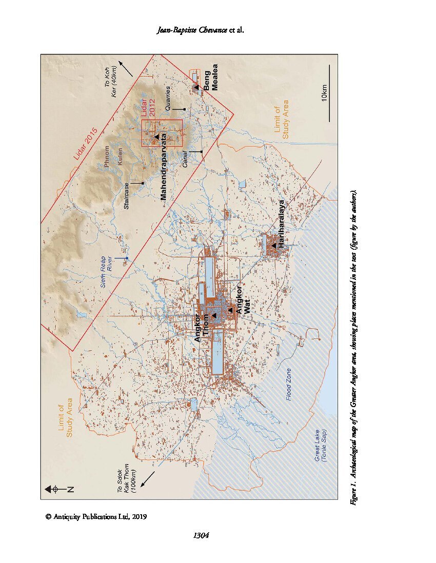
Mahendraparvata (មហេន្ទ្របវ៌ត) as an ancient city of the Khmer Empire era in has been known for decades, but much of it lay concealed by forest and earth. The city was uncovered by an archaeological expedition led by Jean-Baptiste Chevance and Damian Evans in 2012, with the aid of airborne laser scanning technology (LIDAR).
Its origins date to the reign of Jayavarman II, considered the founder of the Khmer Empire. His reign was consecrated on the sacred mountain of Mahendraparvata. Mahendraparvata was one of the three capitals, or courts, of Jayavarman II’s reign, the others being Amarendrapura and Hariharalaya.
The 1936 expedition of French archaeologist and art historian Philippe Stern helped to discover there some previously unknown temples and Vishnu statues. But the area, while being the source of rivers flowing south to the Tonle Sap, was remote and, later in his reign, Jayavarman II moved to Hariharalaya where he died in 835 AD.
The name Mahendraparvata means “Mountain of the Great Indra”. It is derived from the Sanskrit words महेन्द्र (Great Indra, a title of the Hindu god Indra) and पर्वत (mountain), a reference to the hill top site known as Phnom Kulen, today where Jayavarman II was consecrated as the first king of the Khmer Empire in 802. The name is attested in inscriptions at the Angkor-area Ak Yum temple.
Further research with airborne laser scanning
“Mahendraparvata: an early Angkor period capital defined through airborne laser scanning at Phnom Kulen”,
Jean-Baptiste Chevance, Damian Evans, Nina Hofer, Sakada Sakhoeun and Ratha Chhean, Antiquity 93/371, 2019 (published online by Cambridge University Press).
This study confirms and expands previous findings by the authors, in particular the axial arrangement of the temple, pyramid and reservoir which, they note, “recalls the pyramid-reservoir-temple configuration at the tenth-century Angkorian capital at Koh Ker.”
Lidar imaging has also clarified the intricated network of canals on the Kulen mountain, in particular
a channel located at the southernmost point of the valley. Here, the natural direction of flow is to the north, but this 1km-long structure instead channels water to the south. We also found evidence here for water-control mechanisms, such as sluice gates, carved into the stone. These structures divert water over the escarpment and down into the area between Phnom Kulen and Beng Mealea, from where sandstone blocks were quarried and transported down canals to build the temples of Angkor (Uchida & Shimoda 2013). Lidar imaging has revealed the full extent of quarries in this area, along with dykes for controlling the water required for moving the stones (Evans 2016). We can now see evidence that engineering works on top of the plateau also played a role in this sophisticated hydraulic system. [p 1314 – 5]
- You can read the online version by Cambridge Core here.
- In 2016, the Smithsonian Institute magazine published an extensive report on Jean-Baptiste Chevance and Damian Evans’ exploratory work around the Phnom Kulen Plateau. The report was the very first entry in the Publications Section on Angkor Database, see here.
- This latest publication has already been reviewed in Newsweek, CNN, and other major international media.
- Read the official Masterplan for Kulen National Park by the Cambodian Ministry of Environment (2018−2027).
Tags: Jayavarman II, Khmer capital cities, Mahendraparvata, lidar, rediscovery, canals
About the Authors
Jean-Baptiste "JB" Chevance
After graduating from École du Louvre in 1997, and obtaining a PhD in Khmer Archeology in 2011 at Sorbonne-Paris III University, Jean-Baptiste Chevance has focused his research on the Phnom Kulen Mountain, 25 miles north-east from Angkor proper.
Prospecting the mountainous area right after the demise of the Khmer Rouge guerilla, the archeologist has worked with EFEO, INRAP and Apsara Authority, lauching in 2007 the Archaeology and Development Foundation (ADF), devoted to the preservation of the Phnom Kulen site.

Damian Evans
A Canadian-Australian researcher, Damian Evans (d. 12 Sept 2023, Paris, France) focused on archaeological landscapes in mainland Southeast Asia, in particular those of the Khmer Empire.
He specialized in using advanced remote sensing technologies such as airborne laser scanning (or “LIDAR”) to uncover, map and analyse the urban and agricultural networks that stretched between, and beyond, great temple complexes such as Angkor in Cambodia.
Fellow researcher with the University of Sydney, then the Institut Francais d’Etudes Asiatiques, then EFEO, he has published several essays on Angkorian archaeology and mapping.
“In 2015, his team carried out the most extensive airborne study ever taken by archaeologists – using a laser radar mounted on a helicopter to scan an area of the jungle in Cambodia comparable in size to greater London”, read his obituary in The Guardian.
Nina Isabella Hofer
A specialist in archeological laser scanning, Nina Hofer is a graduate of Vienna University, Department of Geography and Regional Research.
In 2018, she co-directed the CALI (Cambodian Lidar Initiative) field season with Leng Vitou of the Cambodian Ministry of Culture and Fine Arts. She wrote about the findings on post-Angkorian capital cities of Longvek and Oudong here.

Sakada Sakhoeun
Sakada Sakhoeun (1986, Phnom Penh) is a senior archeologist with ADFKulen.
Involved in several archaeological projects for Sydney University (Australia) and Sophia University (Japan), Sakhoeun joined the Archeological and Development Foundation/Phnom Kulen in 2009, spending his time between the ADF office in Siem Reap and the archaeological sites on Phnom Kulen.
Since mid-2017, Sakada has taken over the local responsibility of the organization, in coordination with the management team. He is also closely supervising the ADF environmental activities.