125 km (85 miles) to the northeast of Siem Reap and Angkor, the site of Koh Ker (ប្រាសាទកោះកេរ្ដិ៍, in the past known as Chok Gargyar (The Koki (Iron Tree) Forest) and Lingapura (The City of Lingas in Sanskrit) continues to puzzle historians and archaelogists. Since Lunet de Lajonquiere, Etienne Aymonier and Henri Parmentier’s pioneering finds, it has been assumed that a large royal city (a square 1,2 km long) has existed there, erected by King Jayavarman IV in a short time span of some 20 years in the middle of the 10th century — when Ishanavarman II simultaneously reigned in Angkor until his death in 928 –, expanded by his successor Harshavarman II after his death in 941, until the latter’s cousin, Rajendravarman I, wrestled the power away from him and moved the capital back to Yashodharapura.
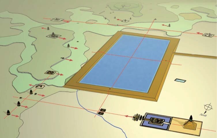
First, the authors summarize the city plan as we now understand it: “Ancient Khmer cities were considered symbols of royal power, and were generally composed of a pyramidal “state temple” in the center of the city, a large rectangular reservoir, and multiple temples surrounding the central temple and reservoir. This naturally also applied to Koh Ker. The city was composed of many temples surrounding a rectangular man-made pond called “Rahal” (“sacred pond” in Pali) which stretched in a north-south direction, and Prasat Thom (KK01), featuring a five-tiered step pyramid temple conventionally called “Prang”, which stood at the rear of the state temple.”
Then, with an extensive study of construction materials, orientation of buildings and fragments, alignment of temples in relation to the main baray (reservoir), brings them to consider that the “concept that the sacredness of the linga was aggregated into the Rahalallows for an effective interpretation of the orientation of the temples on the ridge east of the Rahal. Many temples faced to west in this area. Parmentier assumed that these temples were constructed to face the ancient road that was assumed to penetrate this group of monuments. However through current research, the ancient road was found to pass by the northern side of this group of monuments. If we follow the same theoretical relationship between the Rahal and the linga (KK21), other temples which are placed on the west slope of the eastern ridge facing the Rahal may provide a source for sacred water. Water poured on the linga flowing from the shrine through the somasutra and discharging down to Rahal provide the conceptual image. The location of the many remains of linga-yoni pedestals on laterite platforms, a unique structure only found in this group of monuments, also contributes to the same conceptual image. Many structures, except for KK40 and KK117, are placed on the northward down slope ground of the southern side of Rahal. Therefore, conceptually the sacred water from these lingas floweddown the natural terrain and into the Rahal. Moreover, KK20 (Ang Khna) where there are many deities carved on the natural rock bed at the southeast of Rahal, may express the same concept. In order to purify rain water, these carvings possibly performed the same function as those carved in the river bed at the Kulen Hills and Kbal Spean. Thus the sacredness from each temple was aggregated and integrated in the reservoir Rahal. This sacred water drained north and passed in front of Prasat Thom, and was stored in a second reservoir at the north. Finally, sacred water dispersed to the north and was utilized as agricultural water in the low land.”
Aerial view of the central area of Koh Ker. Many religious facilities, temple complexes, pedestals on platforms, and boundary stones surrounding the Rahal, are unified with a state temple Prasat Thom and reservoir Rahal in an accurate layout. (from the paper)
In conclusion, “one of the characteristics of the Koh Ker monuments is the repetitive nature of the linga religious complex. The significant layout of the temples a nd civil remains in this group of monuments has been understood through spatial analysis, and as Parmentier insisted, the entire city formed a magnificent Siva temple. This reputation was formed by evidence of intensive worship of the linga installed on the top of the pyramid-shaped Prang of Prasat Thom. Several satellite temples and a long pilgrimage road are specifically related with this supreme linga. Another important religious concept portrayed at Koh Ker is the accumulation of water passed over the linga, sanctified, then channeled into the Rahal. This reservoir worked as a basin for collecting the sacred water from each temple around the Rahal and integrated these temples into a homogeneous sacred landscape. The sovereign who realized the rare relocation of the capital from Angkor seems to have used the linga as the overwhelming religious centripetal force in the new capital.”
Dr. Shimoda Ichita 下田 一太 is an architectural historian who has been extensively working on Angkorean sites.
With a Ph.D. in Architectural History of Southeast Asia at Waseda University, Tokyo, Dr. Shimoda is currently Associate Professor at the World Heritage Program in the University of Tsukuba, Japan.
He has worked on the restoration sites at major Cambodian Monuments, such as Angkor Wat, Bayon, Sambor Prei Kuk, Koh Ker, and is a a Technical Advisor of the Japanese Government Team for Safeguarding Angkor, UNESCO Japanese Funds-in-Trust Project.
In addition, he carries on several research and conservation projects across Southeast Asia, and was involved in the nomination and management of Japanese World Heritage sites within the Agency for Cultural Affairs of Japanese government between 2016 and 2019.
Conservation and adaptive reuse of the architectural heritage including traditional building, historical city, and archaeological monuments are important issues for him, and he is the founder of the Shimoda Laboratory of Architectural History.
Shimoda Ishita has been decorated with the Royal Medal of Sahametrei from the Kingdom of Cambodia in 2006 (for his work at Sambor Prei Kuk) and in 2012 (for his work at the Bayon Temple).
Katsura Sato
A graduate from the School of Science and Engineering at Waseda University, Japan, Sato Katsura 佐藤 桂 is a researcher in the fields of architectural history, history of Oriental architecture, historical archaeology and heritage conservation.
She has often contributed to the Journal of Architecture and Planning, in particular on Khmer and Laotian ancient architectural concepts, planning and techniques.
sk लिङ्ग linga, 'penis', 'grammatical gender', 'mark', 'sign', 'a type of ancient temple' | kh លិង្គ lengk 'gender', 'feature', 'attribute', 'male genitalia'
The liṅga is a semi-iconic (between the iconic and the aniconic) image of Śiva. A cylindrical shaft with phallic connotations, it is often associated to the yoni, symbolic representation of the female genitalia, the matrix of anything [1].
The linga symbol is ever-present in Southeast Asian architecture and religious representations. It has absorbed ancient local cults of uncut stones. Associated with fertility rituals in Cambodia, it became the physical embodiment of the kamraten jagat raja or devaraja, the vector of the divine essence attached to kingship.
[1] In Tibetan Vajrayana (tantric Buddhism), 'liṅga' refers to the “upper genitals” [penis or clitoris].
kh ប្រាង្គ, th ปรางค์ ; compoud of sk pra- ("forward) and aṅga (body limb).
A tall tower-like spire, usually richly carved, common shrine element of Hindu and Buddhist architecture in the Khmer Empire (802–1431). Later adapted by Buddhist builders in Thailand, especially during the Ayutthaya Kingdom (1350–1767) and Rattanakosin Kingdom (1782–1932). In Thailand, only related with most important Buddhist temples.