Combining archaeology, botanical exploration, orography, anthropology and geography, this exploration report was published shortly after Jean Boulbet had discovered the site of Kbal Speanក្បាលស្ពាន (“Bridge Head”) [Kpal Sban in his peculiar transliteration] in 1968 [preliminary report: Kbal Spéan, la rivière aux mille linga, Nokor Khmer, 1/2, 1970, pp. 2 – 17]. With archaeologist Bruno Dagens, from January 1967 to June 1970, he roamed an area of approximately 30 sqkm, starting from the west in the vicinity of “Pândây Sri” (Banteay Srei) to reach to the east the vast architectural complex of “Poen Mâlâ” (Beng Mealea), including the northern and northeastern regions of Phnom Kulen.
The area, which the authors call “un château d’eau indispensable pour les vastes ouvrages économiques et religieux de la région d’Angar (Angkor), et, vraisemblablement, un arrière-pays non négligeable” [“a water tower essential to the vast economic and religious works of the Angar (Angkor) region, and, probably, a significant hinterland”], called “hill country” or “forest country” by the inhabitants of the Angkor region, remains mysterious at many levels, in spite of
l’importance historique de cette contrée forestière où abondent les aménagements anciens parfois repris par les habitants actuels, souvent délaissés de nos jours et même largement oubliés. Également oubliés ou ré-interprétés sont les thèmes, brahmaniques aussi bien que bouddhiques, qui ont inspiré les sculpteurs de la grande époque. Il est frappant de constater non pas le manqué mais la déviation de l’intérêt porté à ces vestiges par les Khmers d’aujourd’hui, aussi bien laïcs que moines, ermites ou même Maîtres spirituels (Grû) réputés. Quelques-uns des commentaires, en reproduisant les légendes actuelles, donnent une bonne idée de ces mutations qui peuvent surprendre plus d’une personne avertie mais dont nul né s’inquiète sur place [the historical significance of a forest region where ancient developments abound, sometimes taken over by current inhabitants, often abandoned today and even largely forgotten. Also forgotten or re-interpreted are the themes, Brahmanical as well as Buddhist, which inspired the sculptors of the great era. It is striking to note not the lack but the deviation of the interest shown in these vestiges by the Khmers today, both lay people and monks, hermits or even renowned spiritual masters (Grû). Some of the comments, by reproducing current legends, give a good idea of these mutations which can surprise more than one informed person but which no one worries about on site. [1].
Completed with abundant photographs, drawings and plans, the study remains a reference for contemporary researchers specializing in Phnom Kulen and its foothills. We’ll quote here the part dedicated to Kbal Spean, or Thousand-Linga River. In the rich iconography and the local traditions surrounding the site, we can find Brahma, Vishnu, Shiva-Linga, the Ramayana, Buddhist representations, and heroes of Cambodian legends.
[1] In 1997, however, Prof. Ang Choulean noted that “le Phnom Kulèn est si important que la rivière de Siemréap qui y prend sa source devenait du même coup une rivière sacrée comme en témoigne l’inscription de Bat Chum (K.266 – 268)40 : « Que personne né se baigne ici dans l’eau provenant du tirtha (rivière), né au sommet de la sainte montagne du Mahendra ». Le Kulèn est vénéré jusqu’à nos jours même. Nous sommes loin de tout savoir des constructions anciennes que porte ce vaste site, mais ce dont nous sommes sûrs, c’est qu’à toutes les époques il reçoit des constructions. À l’Époque moyenne les Khmers y ont érigé un grand Buddha couché. Aujourd’hui encore, alors que son accès est devenu difficile, son prestige demeure immense, même chez ceux qui n’ont aucune idée de sa localisation. On né compte pas, par exemple, le nombre de médiums de Phnom Penh ou d’ailleurs qui prétendent incarner, en transe, des saints vivant dans ces collines.”[Phnom Kulèn is so important that the Siemreap river which has its source there also became a sacred river as evidenced by the Bat Chum inscription (K.266 – 268)40: “Let no one bathe here in the water coming from the tirtha (river), born at the top of the holy mountain of Mahendra”. The Kulèn is revered even to this day. We are far from knowing everything about the ancient constructions on this vast site, but what we are sure of is that there have been constructions on it at all times. In the Middle Period the Khmers erected a large reclining Buddha there. Still, while its access has become difficult, its prestige remains immense, even among those who have no idea of its location. We cannot count, for example, the number of mediums from Phnom Penh or elsewhere who claim to embody, in trance, saints living in these hills. [Ang Choulean, “Un point de mémoire collective dans le Cambodge ancien”, BEFEO, t. 84, 1997, p. 338]
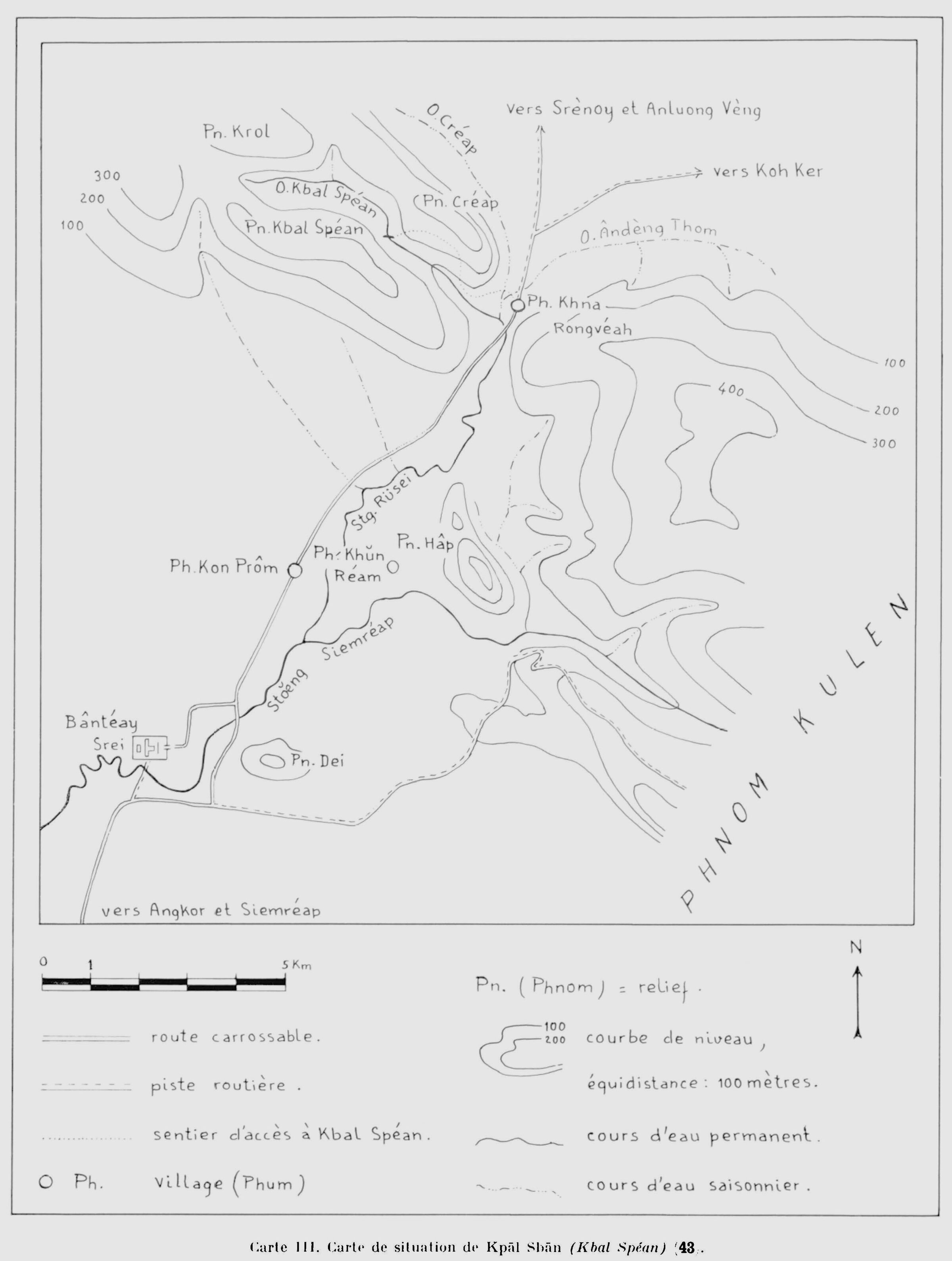
Découvert en février 1968 et dégagé en février et mars de la même année, ce site est accessible par une sente nouvellement tracée à partir du village de Khnâ Ranvâs. Une marche en sous-bois de forêt dense comportant quelques passages rocheux et accidentés conduit en 50 minutes environ au rebord supérieur de la cascade, point aval de la partie décorée de la rivière. Le site se développe sur près de 200 mètres ; pour en faciliter la description on l’a divisé conventionnellement en 15 sites secondaires, numérotés d’aval en amont. et repérés de la sorte sur le plan III [this map (“Carte IV” in the table of contents) is missing in the e‑version we obtained.] . Ces numéros correspondent également à ceux des photographies dont le commentaire forme la description du site. Le plan appelle les remarques suivantes : — Les lignes brisées figurent les bordures rocheuses : abrupts, surplombs, cavités, blocs en couches sub-horizontales ou en chaos. L’érosion des grès en pays tropical humide a dessiné le modelé souvent compliqué, parfois surprenant, de ces entassements de rocs. Une végétation rupicole discontinue et caractéristique (Fougères, Aracées, Araliacées, Ficus tentaculaires et espèces lianescentes variées) s’accroche partout où elle peut et habille partiellement la roche. — Les hachures figurent la forêt dense des rives terreuses. Il s’agit d’une galerie de grands arbres bordant le lit du cours d’eau dès que la roche s’écarte suffisamment pour lui laisser la place. Ces galeries se différencient nettement de la forêt dense des crêtes et des pentes, généralement moins puissante ou moins homogène, par la hauteur et la vigueur de leur étage dominant (Grandes Sterculiacées très disséminées et, bien plus fréquentes, des Diptérocarpées (ici, surtout Hopea)).. Sur les rives, le sous-bois se distingue aussi par son épaisseur, sa composition (Palmacées, Aracées, Araliacées…) et par l’abondance des espèces lianescentes, étreignantes ou epiphytes. — Sur la rive aval occidentale (bas du plan, rive droite à gauche du lecteur), un tertre naturel formé à la base de blocs de grès superposés, très abrupts vers l’Est et le Nord, a été anciennement aménagé. La figuration d’éléments architecturaux, disjoints et incomplets, signale quelques assises de grès et de latérite taillées sur le sommet même du tertre. Un linga, peut être le linga d’or des inscriptions, a pu être dressé sur cette position dominante. — Les linga sont figurés par des cercles. Comme ils sont très nombreux et ornent certaines parties du lit rocheux d’un pavage régulier, ils né peuvent être exactement dessinés à l’échelle du plan. Les cercles non achevés suggèrent ces alignements de linga, inégalement visibles d’ailleurs selon leurs dimensions variables (0,20 m de diamètre en moyenne), la profondeur de l’eau, l’épaisseur des dépôts ou le degré de résistance aux forces d’érosion. Régulièrement alignées et orientées, les bandes qui découpent géométriquement ce pavage sont dessinées à leur place et à leur dimension, réduite normalement à l’échelle du plan. Les cercles bien individualisés, d’une plus grande dimension et inscrits dans un quadrilatère, figurent exactement les linga isolés, bien mis en évidence par les sculpteurs. — Coupe en profil : la ligne en tireté figure le trajet des eaux détaché en deux points du tracé du lit apparent : a) En amont, l’eau passé en perte sous le pont naturel de la photo 11 et né ressort à l’air libre que 60 mètres plus loin. b) En aval où l’eau plonge nettement dans le vide, en avant de la paroi de la cascade dont le bord supérieur est en surplomb. [Discovered in February 1968 and cleared in February and March of the same year, this site is accessible by a newly traced path from the village of Khnâ Ranvâs. A walk through dense forest undergrowth with some rocky and uneven passages leads in around 50 minutes to the upper edge of the waterfall, point downstream of the decorated part of the river. The site extends over nearly 200 meters; to facilitate the description it has been conventionally divided into 15 secondary sites, numbered from downstream to upstream. and marked in this way on plan III [this map (“Carte IV” in the table of contents) is missing in the e‑version we obtained.] . These numbers also correspond to those of the photographs whose commentary forms the description of the site. The plan calls for the following remarks: — The broken lines represent the rock edges: steeps, overhangs, cavities, blocks in sub-horizontal layers or in chaos. The erosion of sandstones in humid tropical countries has created the often complicated, sometimes surprising, shape of these piles of rocks. Discontinuous and characteristic rupicolous vegetation (Ferns, Araceae, Araliaceae, sprawling Ficus and various lianescent species) clings wherever it can and partially covers the rock. — The hatching represents the dense forest of the earthy banks. It is a gallery of large trees bordering the bed of the watercourse as soon as the rock moves aside enough to make room for it. These galleries are clearly differentiated from the dense forest of ridges and slopes, generally less powerful or less homogeneous, by the height and the vigor of their dominant floor (Large, very disseminated Sterculiaceae and, much more frequent, Dipterocarps (here, especially Hopea)). On the banks, the undergrowth is also distinguished by its thickness, its composition (Palmaceae, Araceae , Araliaceae…) and by the abundance of lianescent, hugging or epiphytic species. — On the western downstream bank (bottom of the map, right bank to the left of the reader), a natural mound formed at the base of superimposed sandstone blocks, very steep towards the East and the North, was formerly developed. The representation of architectural elements, disjointed and incomplete, indicates some layers of sandstone and laterite cut on the very summit of the mound. A linga, perhaps the golden linga of the inscriptions, could have been erected on this dominant position. — The lingas are represented by circles. As they are very numerous and adorn certain parts of the rock bed with a regular paving, they cannot be exactly drawn to the scale of the plan. The unfinished circles suggest these alignments of linga, unevenly visible moreover depending on their variable dimensions (0.20 m in diameter on average), the depth of the water, the thickness of the deposits or the degree of resistance to the forces of erosion. Regularly aligned and oriented, the strips which geometrically cut this paving are drawn in their place and to their size, normally reduced to the scale of the plan. The well-individualized circles, of a larger dimension and inscribed in a quadrilateral, represent exactly the isolated linga, well highlighted by the sculptors. — Section in profile: the dashed line represents the path of the water detached at two points from the outline of the apparent bed: a) Upstream, the water passes under the natural bridge in photo 11 and only comes out into the open air 60 meters further. b) Downstream where the water plunges clearly into the void, in front of the wall of the waterfall whose upper edge is overhanging.]
Map III by J. Boulbet. We are looking for Map IV.
Map III by J. Boulbet. We are looking for Map IV.
Descriplion
1) Cascade dite «de la grenouille», du nom d’un relief sculpté juste avant le saut (voir photo 4). Cette chute sépare les cours supérieur et moyen de la rivière Kpâl Sbân (Kbal Spéan) ou «d’amont du pont» (1). Alors qu’en amont le bassin d’alimentation s’étale largement en une cuvette suspendue peu accidentée, le cours moyen, dès le pied même de la cascade, se resserre, s’étrangle jusqu’à disparaître sous les amas chaotiques de rochers. Dans le massif gréseux tout entier, en effet, les sommets quasi tabulaires contrastent avec des pentes parsemées de blocs rocheux, terminées en éboulis et parfois dressées en falaises abruptes, voire surplombantes, au-dessus des plaines environnantes. Tout aussi subitement, la rivière « d’amont du pont » deviendra au contact des « terres plates » le Sdin Rssï (Stoeng Rusei), « la (grande) Rivière des Bambous », paisible et méandreuse. C’est au terme de ce cours inférieur qu’elle rencontrera le Sdin Siemrâp (Stoeng Siemréap) « la Rivière de Siemréap », dont elle est le principal affluent et même le seul affluent permanent reçu en plaine. Comme la lèvre supérieure de la cascade surplombe le vide, des cavités naturelles ont été aménagées en lieux de retraite derrière le voile d’eau d’importance variable suivant les saisons. On y trouve des vestiges d’ermitages, des débris de statues ou de socles et des inscriptions anciennes (voir photo 2). Les eaux s’élancent d’une gouttière creusée au centre du rebord supérieur et retombent approximativement sur un socle à linga très usé.
2) Inscriptions gravées sur la paroi d’une cavité rocheuse au-dessus de la cascade. D’autres inscriptions sont gravées sous le surplomb de la chute (photo 1), sous le rocher en auvent dit « du taureau sacré » (voir photo 6) et plus en amont, sur une excroissance; du lit même. D’après ces inscriptions actuellement recueillies par estampages et classées par l’E.F.E.O., c’est en 1054 (976 sâka) qu’un ministre de Sûryavarman I a fait décorer le site de mille linga (sahasralinga) et en 1059 (980 sâka) que le roi Udayâdityavarman II a visité solennellement la rivière sculptée et y a consacré un grand linga d’or. Ainsi, comme la rivière principale, mais plus fastueusement encore, l’affluent a été décoré dans sa partie haute afin que les eaux sanctifiées soient dignes de se mêler à celles de la Rivière de Siemréap, d’aller baigner les enceintes des temples magnifiques et d’alimenter les cités royales. Il est remarquable que, dans les deux cas, ce sont les parties du lit situées en amont des cascades qui ont été choisies par les sculpteurs. L’eau vient ondoyer les linga au passage, juste avant de se précipiter dans le vide vers son éminente destination.
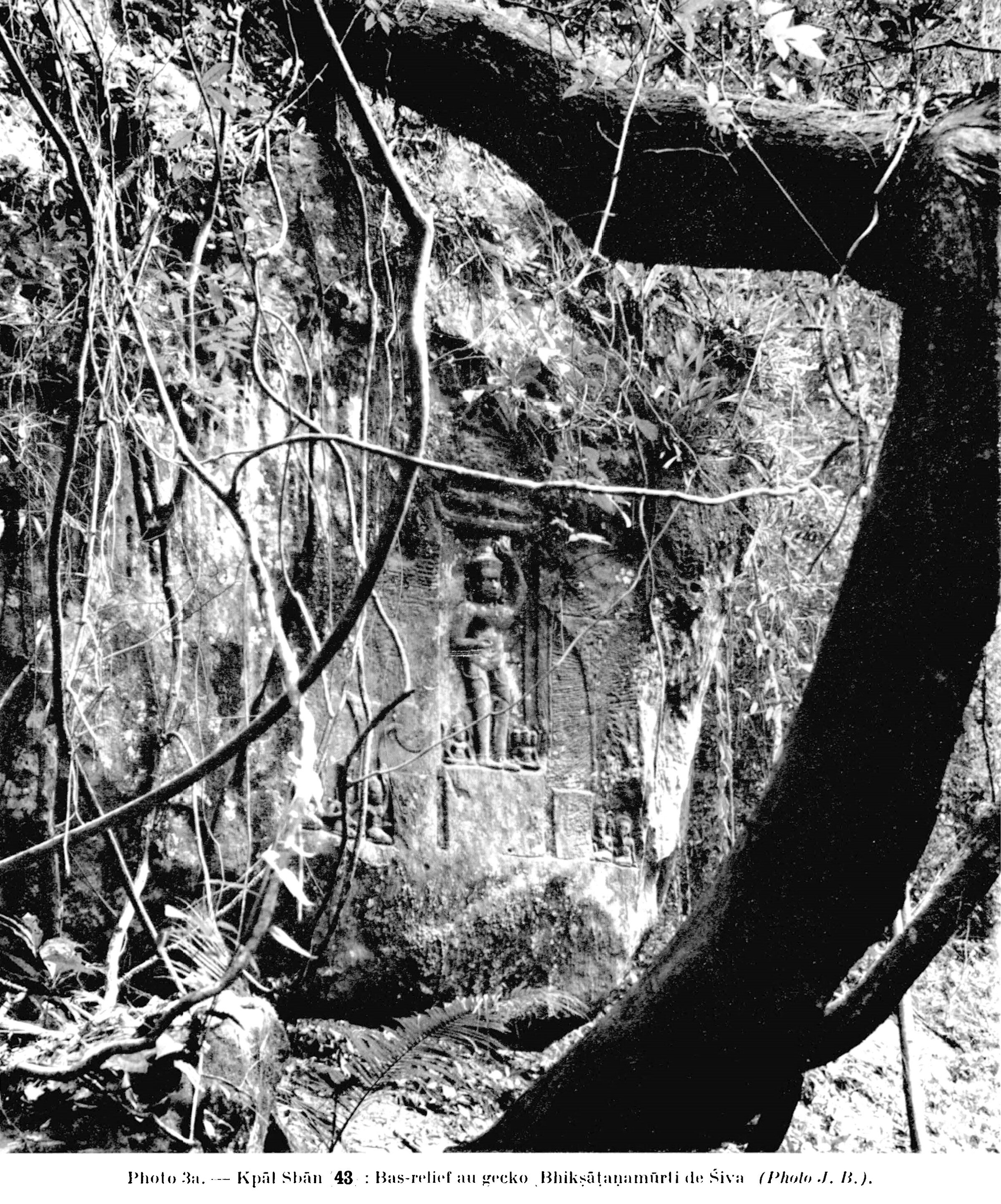
3) En février 1968, lors du premier dégagement de la rivière aux mille linga, cette paroi est restée couverte de mousses, de lianes et de feuillages. Ce n’est que le mois suivant, lors d’un nettoyage plus poussé, que le relief a été mis à jour. Dernier ermite du lieu, le Grû Tep Mei avait quitté les cavités rocheuses des environs de la cascade en 1962. Pour lui, le personnage central debout sous un crocodile représente le Buddha, sage parfait, qui, imperturbable et droit, triomphe des séductions, des embûches et des questions insidieuses. Pour d’autres Khmers de la région, il s’agirait peut être de Krai Thun, prince-héros qui conquit sa princesse en la disputant à un crocodile ravisseur. De toutes façons les habitants des villages les plus proches, aux pieds des collines, n’ont vu le site dégagé et les reliefs rendus à la lumière qu’en fin mars 1968, après le nettoyage du lit de la rivière et l’aménagement d’un sentier d’accès. Pour certains, la scène qui est représentée ici est identique à celle d’un bas-relief d’Angkor Vat et évoque le même thème : l’attente du roi Râp (pour : Râvana) déguisé en gecko au-dessus de la porte des appartements du dieu Isûr (Préah Eiso). Avec des noms de héros variés, ce conte du saurien guettant à la porte d’un gynécée est maintes fois repris. Tel que je l’ai entendu dans la contrée, il s’agit du dieu Isûr partant de son palais pour une retraite de sept jours en forêt et du roi Râp caché sous la forme d’un gecko. En quittant son épouse Sujjatâ, le dieu récite la formule qui seule permet d’ouvrir les portes de ses appartements ; formule que Râp, à l’affût au-dessus de l’entrée né manqué pas d’entendre et de retenir. Le troisième jour, Râp pénètre donc facilement dans la chambre de Sujjatâ, invente une fable pour motiver un prétendu retour imprévu, couche jusqu’au septième jour avec la divine épouse puis s’enfuit avant l’arrivée du maître de céans. Lorsque celui-ci revient comme convenu, Sujjatâ comprend sa méprise et se tue submergée par la honte. Elle renaîtra sous le nom fameux de Sïtâ et, lors de cette nouvelle vie mouvementée, elle retrouvera le roi Râp qui sera alors son ravisseur. De telles interprétations des reliefs rupestres né sont pas du tout exceptionnelles. Ici, l’histoire n’a pas à s’appuyer sur une chronologie bien établie ni même sur des bases certaines ou tout au moins recoupées. Elle existe par elle-même, basée sur des contes étonnants et bien dits où se trouvent intimement mêlés les légendes populaires, les récits tirés de la mythologie brahmanique, l’épopée de Râm (Réam pour Râma), les péripéties de la vie du Buddha ; le tout sans aucune contradiction apparemment gênante et dans un syncrétisme parfait.
4) Bassin creusé à même la roche du lit sur le rebord supérieur de la cascade, juste avant que les eaux né plongent dans le vide. Seule est visible la fameuse grenouille, d’ailleurs petite et à peu près informe, en relief sur la margelle du bassin. Comme cette « baignoire » est toujours pleine, le décor des parois se devine à peine sous l’eau le plus souvent claire. Pour les besoins de la photographie, le bassin a été asséché alors que la rivière était à son niveau le plus bas, ce qui permet d’en distinguer le décor. Émoussés sur la paroi aval où bute le courant, les reliefs sont nets sur les trois autres parois. Ici aussi, les rares ermites et les coureurs de jungle plus rares encore qui avaient vu le bassin né connaissaient pas les sculptures intérieures. Toutes les roches gravées du site sont actuellement nommées « Rûp Athân » ou « formes (sculptées) à pouvoir magique ». C’est-à-dire qu’elles étaient plutôt évitées que fréquentées avant le dégagement de mars 1968.
Pour les ermites de l’école du Grû Tep Mel qui s’appliquent à maîtriser leur soufflé, le dieu Visnu maintes fois représenté est le Grand Ermite, l’une des formes du Buddha. Reposant sur le nâga polycéphale, le Grand Ermite a bloqué son soufflé vital au sommet du crâne, à hauteur de la fontanelle, l’empêchant de « redescendre » vers les autres ouvertures du corps. Il peut alors projeter son esprit hors de lui, un esprit devenu parfaitement lucide et capable d’appréhender l’essence des choses dans les quatre horizons en même temps. Cette projection c’est la figure à quatre faces (la représentation de Brahmâ naissant sur lotus) ; autant dire, pour les Grû de cette école, la perfection vers laquelle ils tendent tous.
Quant aux villageois qui ont participé au dégagement du site, ils reconnaissent bien, pour la plupart, les dieux Nâràyan’ (Visnu) et Brahmâ dont les images sont maintes fois gravées dans le lit de la rivière aux mille linga comme sur d’autres roches de la région. Certains voient dans les femmes dont une tient la queue d’un crocodile, la princesse « Cristal aux sept couleurs » et ses suivantes. Cette princesse, héroïne d’un conte populaire, est représentée suivant son crocodile aimé depuis le bassin du palais royal jusqu’au grand réservoir du Baraij occidental qu’elle a fait aménager pour lui.
5) Plus facile à assécher parce que non approvisionné en saison sèche, ce bassin de section carrée présente seulement deux parois sculptées. Le relief de la paroi aval (photo 5c) est émoussé (moins cependant que son correspondant de la photo 4, le courant n’arrivant ici qu’en saison des pluies), alors que son vis-à-vis est très précis. Des margelles nettes entourent la fosse au fond de laquelle on peut voir les restes d’une protubérance, sans doute d’un linga comme cela doit être également le cas dans le bassin du cliché précédent encombré de débris en son centre. D’une profondeur de 1 mètre environ, ce bassin carré a 2 mètres de côté.
6) Avec la grenouille informe, ce taureau monté par Siva et son épouse était la seule sculpture signalée par le Grû Tep Mei avant la reconnaissance du cours supérieur du Stoeng Rusei. Lors de la grande première, en fin mars 1968, alors que les villageois les plus proches étaient venus visiter leur haut lieu dégagé et pratiquement inconnu pour eux, ce taureau a été aussitôt vénéré ; à ses pieds se sont allumées des baguettes d’encens. Ici l’on n’hésite pas sur l’identité des personnages représentés par le sculpteur : le taureau sacré, Brah Go (Préah Ko) est bien celui du conte célèbre « le Taureau Sacré et le Génie de Cristal » . Derrière le taureau, une roche porte deux inscriptions et, en avant de lui, une autre roche est ornée d’une fleur de lotus sommairement gravée.
7) Vue d’aval vers l’amont, à hauteur du petit saut marqué sur le profil. Déjà, depuis l’amont direct du site 4 et tout autour du bassin du site 5, un grand nombre de linga décoraient le lit de la rivière. On né voit de ces linga que les sommets en calottes arrondies et émoussées par des eaux courantes. Ils sont, le plus souvent, assemblés en compositions géométriques aux lignes toujours orientées. Sur ce cliché on les voit disposés plus librement, utilisant au mieux les accidents de la roche, ici d’un seuil de grès dur sur lequel cascadent les eaux. Pour les Khmers d’aujourd’hui ces boursouflures artificielles du lit de la rivière sont identiques à celles, déjà bien connues, du haut Stoeng Siemréap : ils représentent soit les bains aménagés pour le fameux roi Lépreux, soit disposés par cinq, les oeufs de la reine des corbeaux blancs mythiques. Ils peuvent aussi figurer les fruits du cocotier qui constituent, dans la région, l’offrande religieuse élémentaire et aussi la forme d’autel la plus simple et la plus fréquente aux « Esprits d’origine », à ces Grû invisibles qui, exclusifs et parfois irascibles, surveillent de près la vie des hommes dès la naissance.
8) Ici le lit de la rivière est vu d’amont vers l’aval. A travers la transparence de l’eau, peu profonde de janvier à avril, on peut distinguer les alignements de linga. Sur le rocher de bordure Est (à gauche du cliché) sont gravées d’un trait peu appuyé, trois tours-sanctuaires abritant trois linga, la tour centrale étant la plus grande.
9) Vue prise d’amont vers l’aval à l’endroit où la rivière réapparaît au jour à la sortie de son cours sous-roches. Les bandes encadrant les rangées de linga apparaissent, larges et nettes, toujours orientées. Une « cuve » comme on en voit sur les socles interrompt ce découpage régulier ; son goulet est, comme il se doit, ouvert vers le Nord ; il reçoit donc directement les eaux renaissantes au débouché de la perte. Déjà entourée de linga bien détachés, placés aux quatre axes et aux quatre angles, dans les huit directions, cette cuve enclôt cinq autres linga ordonnés comme les tours des temples-montagnes, comme le mont Meru à cinq sommets. On retrouve ici la disposition des tas de sable du nouvel an khmèr actuel. Aux yeux des villageois « compétents », ce sont là, bien mis en évidence dans leur nid, les cinq oeufs de la reine mythique des corbeaux blancs. De ces cinq oeufs sont nés cinq animaux (coq, nâga, tortue, taureau, tigre) d’où, par la suite des transmigrations, seront issus les cinq Buddha. [C’est ainsi que le coq correspond à Kakusandha, le nâga à Konagamana, la tortue à Kassapa, le taureau au Buddha de notre temps et le tigre à Metteyya, le Buddha futur.]
10) Durant une grande partie de l’année, à l’exception de la période des crues d’août à octobre, les dalles de grès formant le lit visible de la rivière, demeurent à sec au-dessus de l’eau cachée, sous-jacente. Quelques roches accidentent les dalles lisses. L’une d’elles porte quelques mots inscrits, assez peu distincts ; d’autres, vraisemblablement déplacées par les eaux et détachées de la rive, sont décorées ainsi que la roche de bordure en place, sur la rive gauche. C’est encore la « naissance de Brahma » qui a inspiré les sculpteurs.
11) Voici le «pont» naturel qui a marqué toute la toponymie du lieu, puisqu’il a donné son nom à la montagne, à la rivière et au site lui-même. Il s’agit d’une superposition de plaques de grès horizontales formant, en travers du lit de la rivière, un barrage aux bords nets, comme géométriquement découpés, et à la crête tabulaire. Haut de 6 à 7 mètres et large de 8 mètres environ, ce verrou que le torrent sautait peut-être en cascadant, à une époque géologiquement assez récente, est devenu un véritable pont puisque, de nos jours, l’eau, après avoir afouillé le mur amont, s’est frayée un chemin sous la roche qu’elle franchit par une perte en laissant à sec une partie de son lit primitif. Ce pont naturel est d’autant plus remarquable qu’il est orienté Est-Ouest et coupe perpendiculairement une dalle rocheuse creusée d’une rigole dirigeant l’eau coulant du Nord. Il fallait, pour faire de ce lieu un haut lieu, que le site soit parfaitement composé dans ses éléments naturels. Ici la roche spectaculaire et bien orientée marque convenablement l’espace ; l’eau permanente au cheminement curieux mais heureusement dirigé fournissait la deuxième dimension tandis que la montagne et la forêt parachevaient un décor digne d’une petite rivière promise à une grande destinée. Dans la région, le pont, d’ailleurs peu connu, est parfois appelé : Sbân Tup (Sbân Tèn), « le pont orné et décoré ». Sa face Nord (amont) est en effet gravée de reliefs (voir photo 12) tandis que le côté opposé (aval) est laissé dans son état naturel. Pour quelques anciens, ce pont a été aménagé « il y a très longtemps » alors que seul émergeait le sommet du Phnom Kulen, tel un îlot dans l’océan envahisseur. Pour que les eaux diluviennes refluent et dégagent le territoire cambodgien il fallait que le Buddha parvienne sur cette île et fasse reculer les flots. Le pont orné, décoré est le seul vestige du grand cheminement qui a conduit les pas du Sage, de crêtes en crêtes, par-dessus cols et cours d’eau, jusqu’à la montagne sacrée où il a laissé son empreinte vénérée. De là, il a assigné comme limite à l’océan les rivages du Cambodge actuel.
12) Face Nord (amont) du « pont ». Les mêmes thèmes sont repris. Plusieurs rochers basculés et décorés de linga montrent que les reliefs ont bougé depuis leur exécution. Une roche décorée d’un Visnu sur nâga polycéphale n’a été dégagée du sable accumulé sur la rive droite qu’en 1969. Elle est invisible sur les photos et d’un décor d’ailleurs fort émoussé. C’est contre cette face du pont que les eaux butent avant de s’engouffrer sous la roche même qu’elles ont excavée.
13) L’eau débouchant du Nord par deux cascatelles est très exactement ici celle « issue de l’amont du pont ». Toute la roche exploitable a été ciselée. Les roches plates sont semées de linga disposés en « fleur de lotus » inscrites dans des carrés avec, çà et là, quelques linga isolés dans des cuvettes. La tranche verticale des deux ressauts est gravée de linga représentés sur toute leur hauteur et voulant figurer le profil en coupe du lit boursoufïïé de linga dont on né voit ailleurs que les calottes sommitales. Sur le ressaut supérieur, d’un relief plus inégal, se succèdent des Visnu couchés sur nâga, un cortège avec, en son centre, le taureau Nandin monté par Siva et son épouse, des orants, etc. Le décor des bordures sur la rive gauche (Est) a été dégagé sous une épaisse couche de sable et a été trouvé dans un état d’altération très avancé. Il se devine cependant sur l’image, à la lisière même de la forêt.
14) Constitué de plaques de grès traversées d’une gouttière centrale, le lit est décoré de linga soit en rangées, soit disposés en cercles inscrits dans des cuves plus ou moins sommaires. Certains sont isolés et l’on trouve là le plus gros de tout le site (1 m de rayon) margelé d’une large cuvette toujours ouverte d’un goulet vers le Nord. Sur la rive droite (Ouest) la rivière reçoit un afïluent de saison des pluies, puis les derniers linga disparaissent dans une fosse au fond vaseux. Un coude apparaît, changeant l’orientation du cours d’eau et ici se termine (ou plutôt commence en suivant le fil de l’eau) la partie sculptée de la rivière aux mille linga.
15) Cependant demeure sur la rive gauche (Est) une image de Brahmâ sur lotus traitée d’un seul bloc. Ce rocher sculpté et actuellement couché n’a été découvert que lors des dégagements ultérieurs à la toute première visite. Il est à demi-caché dans les racines, en parties aériennes, des arbres bordant de très près la rivière sacrée.
Translation
1) So-called “The Frog” waterfall, named after a sculpted relief just before the jump (see photo 4). This fall separates the upper and middle courses of the Kpâl Sbân (Kbal Spean) or “upstream of the bridge” river. While upstream the basin supply spreads out widely in a suspended basin with little unevenness, the middle course, from the very foot of the waterfall, tightens and narrows until it disappears under the chaotic piles of rocks. In the entire sandstone massif, in fact, the almost tabular summits contrast with slopes dotted with boulders, ending in scree and sometimes raised into steep cliffs, even overhanging, above the surrounding plains. Just as suddenly, the river “upstream of the bridge” will become, when in with the “flat lands”, the Sdin Rssï (Stoeng Rusei), “the (large) Bamboo River”, peaceful and meandering. It is at the end of this lower course that it will meet the Sdin Siemrâp (Stoeng Siemréap) “the Siemréap River”, of which it is the main tributary and even the only permanent tributary received in the plain. As the upper lip of the waterfall overlooks the void, natural cavities have been converted into places of retreat behind the veil of water of varying importance depending on the seasons. There are remains of hermitages, remains of statues or bases and ancient inscriptions (see photo 2). The water rushes from a gutter dug in the center of the upper edge and falls approximately on a severely worn linga base.
2) Inscriptions engraved on the wall of a rock cavity above the waterfall. Other inscriptions are engraved under the overhang of the fall (photo 1), under the canopy rock known as “the sacred bull” (see photo 6) and further upstream, on an outgrowth; from the bed itself. According to these inscriptions currently collected by stampings and classified by the E.F.E.O., it was in 1054 (976 saka) that a minister of Sûryavarman I had the site decorated with a thousand lingas (sahasralinga) and in 1059 (980 saka) that King Udayādityavarman II solemnly visited the carved river and dedicated a large golden linga there. Thus, like the main river, but even more sumptuous, the tributary was decorated in its upper part so that the sanctified waters were worthy of mingling with those of the Siemréap River, of bathing the enclosures of the magnificent temples and to supply the royal cities. It is remarkable that, in both cases, it is the parts of the bed located upstream of the waterfalls which were chosen by the sculptors. The water ripples the linga as it passes, just before rushing into the void towards its eminent destination.
3) In February 1968, during the first clearing of the thousand linga river, this wall remained covered with moss, lianas and foliage. It was only the following month, during further cleaning, that the relief was revealed. The last hermit of the place, the Grû Tep Mei had left the rock cavities around the waterfall in 1962. For him, the central character standing under a crocodile represents the Buddha, perfect sage, who, imperturbable and upright, triumphs over seductions, pitfalls and insidious questions. For other Khmers in the region, it may be Krai Thun, a hero-prince who conquered his princess by competing with a captor crocodile. In any case, the inhabitants of the closest villages, at the foot of the hills, only saw the site cleared and the reliefs brought to light at the end of March 1968, after the cleaning of the river bed and the development of an access trail. For some, the scene which is represented here is identical to that of à bas-relief of Angkor Wat and evokes the same theme: the waiting of king Râp (for: Râvana) disguised as a gecko above the gate of apartments of the god Isûr (Préah Eiso). With varied hero names, this tale of the saurian lurking at the door of a gynoecium is repeated many times. As I heard it in the region, it is about the god Isûr leaving his palace for a seven-day retreat in the forest and about King Râp hidden in the form of a gecko. Leaving his wife Sujjatâ, the god recites the formula which alone allows one to open the doors of the apartments; formula that Râp, on the lookout above the entrance, does not fail to hear and remember. On the third day, Râp easily enters Sujjatâ’s room, invents a fable to motivate a supposed unforeseen return, sleeps until the seventh day with the divine wife then flees before the arrival of the master of the house. When he returns as agreed, Sujjatâ understands his mistake and kills herself overwhelmed by shame. She will be reborn under the famous name of Sïtâ and, during this new eventful life, she will find King Râp who will then be her captor. Such interpretations of rock reliefs are not at all exceptional. Here, history does not have to rely on a well-established chronology, nor even on certain or at least cross-referenced bases. It has its own existence, based on astonishing and well-told tales in which popular legends, stories taken from Brahmanical mythology, the epic of Râm (Réam for Râma), the life of the Buddha, all closely intertwined, all without any apparently annoying contradiction and in perfect syncretism.
4) Basin dug into the rock of the bed on the upper edge of the waterfall, just before the waters plunge into the void. Only the famous frog is visible, also small and almost shapeless, in relief on the edge of the pool. As this “bathtub” is always full, the decoration of the walls can barely be seen under the usually clear water. For the purposes of photography, the basin was dried up while the river was at its lowest level, which allows the scenery to be distinguished. Blunt on the downstream wall where the current stops, the reliefs are clear on the other three walls. Here too, the rare hermits and even rarer jungle runners who had seen the pool were unaware of the interior sculptures. All the engraved rocks on the site are currently called “Rûp Athân” or “(sculpted) forms with magical power”. That is to say, they were rather avoided than frequented before the clearance of March 1968.
For the hermits of the Grû Tep Mei school who strive to control their breath, the god Visnu, often represented, is the Great Hermit, one of the forms of the Buddha. Resting on the polycephalic naga, the Great Hermit blocked his vital breath at the top of the skull, at the height of the fontanel, preventing it from “descending” towards other openings in the body. He can then project his mind outside of himself, a mind that has become perfectly lucid and capable of apprehending the essence of things in all four horizons at the same time. This projection is the four-faced figure (the representation of Brahmâ being born on lotus); suffice to say, for the Grû of this school, the perfection towards which they all tend.
As for the villagers who participated in the clearance of the site, most of them recognize the gods Nâràyan’ (Visnu) and Brahmâ whose images are many times engraved in the bed of the thousand linga river as well as on other rocks. of the region. Some see in the women, one of whom holds the tail of a crocodile, the princess “Crystal of Seven Colors” and her attendants. This princess, heroine of a popular tale, is represented following her beloved crocodile from the pool of the royal palace to the large reservoir of Western Baraij which she had built for him.
5) Easier to dry out because it is not stocked in the dry season, this square-section pool has only two sculpted walls. The relief of the downstream wall (photo 5c) is blunt (less, however, than its counterpart in photo 4, the current only arriving here in the rainy season), while its opposite is very precise. Clear edges surround the pit at the bottom of which we can see the remains of a protuberance, undoubtedly of a linga as must also be the case in the basin in the previous photo cluttered with debris in its center. With a depth of approximately 1 meter, this square pool has a side of 2 meters.
6) Along with the shapeless frog, this bull ridden by Siva and his wife was the only sculpture reported by the Grû Tep Mei before the recognition of the upper course of the Stoeng Rusei. During the great première, at the end of March 1968, when the nearest villagers came to visit their open high place and practically unknown to them, this bull was immediately venerated; At his feet sticks of incense were lit. Here we do not hesitate about the identity of the characters represented by the sculptor: the sacred bull, Brah Go (Préah Ko) is indeed that of the famous tale “the Sacred Bull and the Crystal Genie”. Behind the bull, a rock bears two inscriptions and, in front of it, another rock is decorated with a summarily engraved lotus flower.
7) View from downstream to upstream, at the height of the small jump marked on the profile. Already, from the direct upstream of site 4 and all around the basin of site 5, a large number of linga decorated the river bed. We only see the tops of these linga as rounded caps blunted by running water. They are, most often, assembled in geometric compositions with always oriented lines. In this photo we see them arranged more freely, making best use of the features of the rock, here a threshold of hard sandstone over which the waters cascade. For the Khmers today, these artificial blisters in the river bed are identical to those, already well known, of the upper Stoeng Siemréap: they represent either the baths built for the famous Leper King, or arranged in fives, the eggs of the queen of the mythical white crows. They can also represent the fruits of coconut palm which constitute, in the region, the elementary religious offering and also the simplest and most frequent form of altar to the “Spirits of origin”, to these invisible Grû who, exclusive and sometimes irascible, closely monitor the life of men from birth.
8) Here the river bed is seen from upstream to downstream. Through the transparency of the water, shallow from January to April, we can distinguish the linga alignments. On the rock on the eastern edge (to the left of the photo) are engraved in a light line, three shrine towers housing three lingas, the central tower being the largest.
9) View taken from upstream to downstream at the place where the river reappears in the light at the exit of its underground course. The bands framing the rows of linga appear, wide and clear, always oriented. A “vat” like we see on the bases interrupts this regular division; its neck is, as it should be, open towards the North; it therefore directly receives the resurgent waters at the outlet of the loss. Already surrounded by well-detached lingas, placed on the four axes and four corners, in the eight directions, this tank encloses five other lingas ordered like the towers of mountain-temples, like Mount Meru with five peaks. Here we find the arrangement of the piles of sand for the current Khmer New Year. In the eyes of the “competent” villagers, these are there, clearly visible in their nest, the five eggs of the mythical queen of white crows. From these five eggs were born five animals (rooster, naga, turtle, bull, tiger) from which, subsequently transmigrations, the five Buddhas will come. [This is how the rooster corresponds to Kakusandha, the naga to Konagamana, the turtle to Kassapa, the bull to the Buddha of our time and the tiger to Metteyya, the future Buddha.]
10) During a large part of the year, with the exception of the flood period from August to October, the sandstone slabs forming the visible bed of the river remain dry above the hidden water, underlying. A few rocks disturb the smooth slabs. One of them bears a few words inscribed, not very distinct; others, probably moved by water and detached from the bank, are decorated as well as the border rock in place, on the left bank. It is again the “birth of Brahma” which inspired the sculptors.
11) Here is the natural “bridge” which determined the entire toponymy of the place, since it gave its name to the mountain, the river and the site itself. It is a superposition of horizontal sandstone plates forming, across the bed of the river, a dam with clean edges, as if geometrically cut, and with a tabular crest. 6 to 7 meters high and approximately 8 meters wide, this barrier that the torrent perhaps jumped while cascading, at a geologically fairly recent time, has become a real bridge since, today, the water, after having scoured the upstream wall, has made its way under the rock which it crosses by a loss, leaving part of its original bed dry. This natural bridge is all the more remarkable as it is oriented East-West and perpendicularly cuts a rock slab hollowed out by a channel directing the water flowing from the North. To make this place a highlight, it was necessary for the site to be perfectly composed of its natural elements. Here the spectacular and well-oriented rock properly marks the space; the permanent water with its curious but fortunately directed path provided the second dimension while the mountain and the forest completed a setting worthy of a small river promised to a great destiny. In the region, the bridge, although little known, is sometimes called: Sbân Tup (Sbân Tèn), “the ornate and decorated bridge”. Its north face (upstream) is in fact engraved with reliefs (see photo 12) while the opposite side (downstream) is left in its natural state. For some elders, this bridge was built “a long time ago” when only the summit of Phnom Kulen emerged, like an islet in the invading ocean. So that the flood waters flow back and clear the Cambodian land, the Buddha had to reach this island and turn back the waves. The ornate, decorated bridge is the only vestige of the great journey which led the steps of the Sage, from ridge to ridge, over passes and waterways, to the sacred mountain where he left his venerated imprint. From there, he assigned the shores of present-day Cambodia as the limit of the ocean.
12) North face (upstream) of the “bridge”. The same themes are repeated. Several rocks tilted and decorated with linga show that the reliefs have moved since their execution. A rock decorated with a polycephalic Vishnu on naga was only excavated from the sand accumulated on the right bank in 1969. It is invisible in the photos and has a very blunt decoration. It is against this face of the bridge that the waters hit before rushing under the very rock that they have excavated.
13) The water flowing from the North through two waterfalls is exactly that “coming from upstream of the bridge”. All the exploitable rock has been chiseled. The flat rocks are strewn with linga arranged in a “lotus flower” pattern inscribed in squares with, here and there, a few isolated linga in bowls. The vertical edge of the two projections is engraved with linga represented over their entire height and intended to represent the sectional profile of the bloated bed of linga of which we see elsewhere only the summit caps. On the upper projection, of a more uneven relief, there are Visnu lying on nâga, a procession with, in its center, the bull Nandin ridden by Siva and his wife, praying people, etc. The decoration of the borders on the left (East) bank was exposed under a thick layer of sand and was found in a very advanced state of alteration. However, it can be seen in the image, at the very edge of the forest.
14) Made up of sandstone plates crossed by a central gutter, the bed is decorated with linga either in rows or arranged in circles inscribed in more or less summary tanks. Some are isolated and we find there the largest of the entire site (1m radius) bordered by a large basin always open with a narrows towards the North. On the right bank (West) the river receives a tributary during the rainy season, then the last linga disappear into a pit with a muddy bottom. A bend appears, changing the orientation of the watercourse and here ends (or rather begins following the water’s edge) the sculpted part of the river of a thousand lingas.
15) However, there remains on the left bank (East) an image of Brahmâ on lotus treated in a single block. This sculpted and currently lying rock was only discovered during the clearings subsequent to the very first visit. It is half-hidden in the roots, in aerial parts, of the trees very close to the sacred river.
“Gecko Bas-relief: la Bhiksâtanamûrti de Shiva” (photo J. Boulbet). On Bhikshatana’s representations in Cambodia, Boulbet recommends the article of B. Dagens in Arts Asiatiques, 19, 1969, pp. 144 – 146.
“Gecko Bas-relief: la Bhiksâtanamûrti de Shiva” (photo J. Boulbet). On Bhikshatana’s representations in Cambodia, Boulbet recommends the article of B. Dagens in Arts Asiatiques, 19, 1969, pp. 144 – 146.
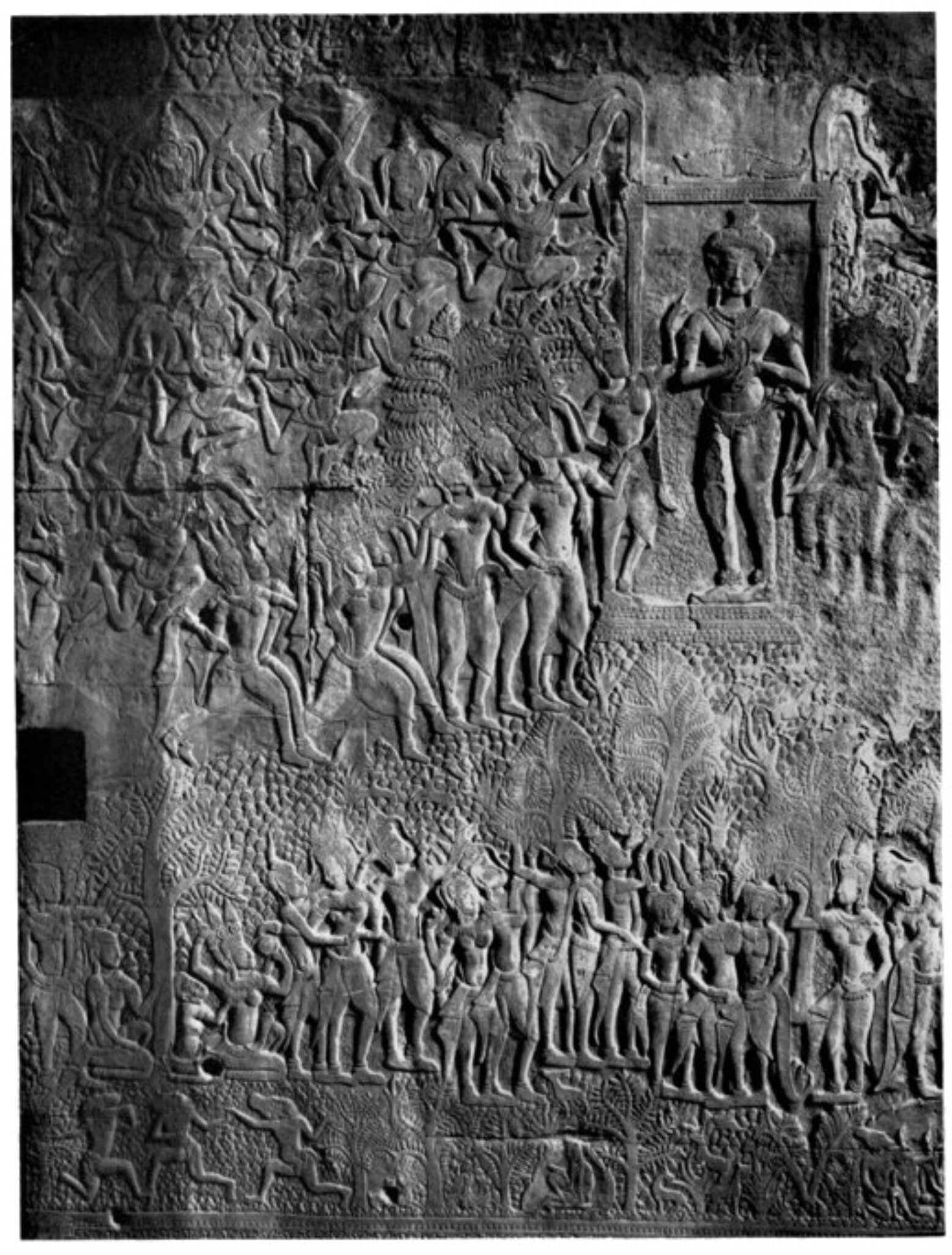
Bhikshatana-mutri and enamored women, relief in Angkor Wat 3d southwestern pavilion identified by Madeleine Giteau in 1965.
Bhikshatana-mutri and enamored women, relief in Angkor Wat 3d southwestern pavilion identified by Madeleine Giteau in 1965.
Self-taught ethnologist, poet, archaeologist, botanist, geographer and cartographer, sociologist, linguist Jean Boulbet (2 Jan. 1926, Sainte-Colombe-sur-l’Hers, France — 11 Feb. 2007, Phuket, Thaïland), had extensively explored since 1946 the Cau Maa’ (“hill people” ethnic minority in Vietnam) territory when ethnographer Georges Condominas called him to take charge of the Angkor site forest conservation in 1963, thus helping in saving him from the South-Vietnamese jails.
While completing his studies in geography and ethnology, with a Ecole Pratique des Hautes Etudes EPHE certification in 1967 under the supervision of Lucien Bernot, Georges Condominas and Claude Lévi-Strauss, Boulbet — nicknamed ‘TaBeh’ (Granddad (Boul)Bet) by the Khmer people — established the first permanent scientific post in the Phnom Kulen area. After contributing to the cartography of Central Vietnam, Northern Cambodia and Southern Thailand, discovering several important archaeological sites such as Kbal Spean (the Thousand Linga River, in which his ashes would be scattered by his Cambodian spouse, Moey, after his death), becoming fluent in Khmer and minority dialects (stieng, mnong…), he was briefly captive of the Khmer Rouge militia in Battambang in 1975, and managed to escape to Thailand, where he first settled in Nonthaburi.
A “montagnard” himself — born and raised among the remote hills of Ariege –, a pioneer in fauna and flora preservation, Boulbet saved several endangered species and actively helped to the reforestation after the war.
His life has inspired French novelists such as Pierre Schoendoerffer (in L’Adieu au roi), François Bizot (Le Saut du Varan) and Loup Durand for his literary saga set in Cambodia, Jaraï.
Further references: One of his four grandsons from his daughter Laure (sired with his first spouse, a Cau Maa´ young woman), Danny Blao, has launched in 2012 a blog dedicated to Jean Boulbet.
Publications:
“Quelques aspects du coutumier (Ndrii) des Cau Maa”, Bulletin de la Société des études indochinoises (Saigon), XXXII (2), p. 3 – 178, 1957.
“Découverte d’un troisième lithophone préhistorique en pays mnong-maa’”, L’Anthropologie, 62 (5−6), p. 486 – 502, 1957 (foreword by Georges Condominas).
“Introduction à l’étude de la forêt dense”, Annales de la Faculté des Sciences (Saigon), p. 239 – 260, 1960 (with Jean-Pierre Barry, Phung Trung Ngân and H. Weiss).
“Description de la végétation en Pays maa’”, Bulletin de la Société des études indochinoises (Saigon), XXXV (3), p. 545 – 574, maps, photos, 1960.
“Bördee au rendez-vous des Génies”, Bulletin de la Société des études indochinoises (Saigon), XXXV (4), p. 627 – 650, 1960.
“Modes et techniques du Pays maa’”, Bulletin de l’Ecole française d’Extrême-Orient (BEFEO), LII (2), p. 359 – 414, drawing, photos, 1965.
“Le miir, culture itinérante avec jachère forestière en Pays maa’”, BEFEO, LIII (1), p. 77 – 98, photos, 5 maps, 1966.
Pays des Maa’. Domaine des génies. Nggar Maa’, Nggar Yaang. Essai d’ethno-histoire d’une population proto-indochinoise du Vietnam Central, Paris, Ecole française d’Extrême-Orient (“Publications de l’EFEO”, LXII), 152 p, photos, maps, 1967.
“Le tragique destin des Maa’”, Etudes cambodgiennes (Phnom Penh), n° 11, p. 14 – 21, 1967.
“Des femmes Bu Dih à quelques apsaras originales d’Angkor Vat”, Arts asiatiques, XVII, p. 209 – 218, 1968.
“Le gibbon”, Nokor Khmer (Phnom Penh), I (1), p. 48 – 61, 1969.
“Kbal Spean, la Rivière aux Mille Linga”, Nokor Khmer(Phnom Penh), I (2), p. 2 – 17, (foreword by Jean Filliozat), 1970.
“Le décor forestier”, Nokor Khmer (Phnom Penh), II (3), p. 44 – 69, drawings by Hervé Manac’h, 1970.
Dialogue lyrique des Cau Maa’, Paris, Ecole française d’Extrême-Orient (“Publications de l’EFEO”, LXXXV), 116 p., photos, 1972.
Les Sites archéologiques de la région du Bhnam Gulen (Phnom Kulen), Paris, Annales des musées Guimet et Cernuschi (numéro spécial Arts asiatiques, XXVII), 132 p., photos, cartes, 1973 (with Bruno Dagens).
“Phnom Kulen, paysage rural particulier au Cambodge”, p. 193 – 205 in Jacques Barrau, LucienBernot, Isaac Chiva and Georges Condominas (eds.), Agricultures et sociétés en Asie du Sud-Est, Paris, Mouton, 53 – 56, 1974.
Paysans de la forêt, Paris, EFEO (“Publications de l’EFEO”, CV), 147 p., maps, photos, 1975.
“Forest degradation in Northeastern Thailand between 1954 and 1973”, chapter 2: “Rural Landscapes“7, chapter 3: photos, in : Interim Committee for co-ordination of investigations of the Lower Mekong Basin. Lao People’s Democratic Republic, Kingdom of Thailand and Socialist Republic of Vietnam (eds) : Interpretation of Remote Sensing Imagery, mkg/R.231, 1979.
Evolution des paysages végétaux en Thaïlande du Nord-Est, Paris, EFEO (“Publications de l’EFEO”, CXXXVI), 76 p., photos, 1982.
“Découvrir ou retrouver. Autour des dernières prospectives de l’EFEO dans la région du Phnom Kulen (1967−1970)”, p. 165 – 181 in Cambodge II, Paris, Ed. de l’Ecole des Hautes études en sciences sociales [n. s. Asie du Sud-Est et Monde Insulidien, XV (1 – 4)], 497 p., 1984.
Forêts et pays. Carte schématique des formations forestières dominantes et de l’occupation humaine en Asie du Sud-Est, Paris, EFEO (“Publications de l’EFEO”, CXLIII), 134 p., maps, photos, 1984.
Un Héritage étrange : les roches peintes. Sites inédits de Thaïlande du Sud. Provinces de Phang Nga et Krabi, Bangkok, Sangwan Surasarang, 36 p., cartes, photos (abstracts fr-thai-eng), with the support of French Ministry of Foreign Affaires, 1985.
Phuket. Réserve de faune et de flore de Khao Phra Thaew, Phuket, Andaman Press, 80 p., maps, photos (fr-eng-thai), 1986 (with Nophadol Briksavan).
Phuket. Image satellite Spot et son exploitation de terrain. Six panneaux commentés, Toulouse/ Paris/Bangkok, Centre national d’études spatiales, EFEO, Asian Institute of Technology, 1988.
Vers un sens de la Terre. Recul des lisières de la forêt dense en Thaïlande méridionale durant les deux dernières décennies / Towards a sense of the Earth. The retreat of the dense forest in Southern Thailand during the last two decades, Pattani, Prince of Songkla University (“Grand Sud”, 5), with EFEO, 138 p., maps, photos (fr-eng), 1995.
De Palmes et d’épines, Tome 1, Vers le Domaine des génies (Pays des Maa’, Sud Vietnam, 1947- 1963), Paris, SevenOrients, 345 p., 32 pl. photos, maps, 2002. De Palmes et d’épines, Tome 2, Vers le paradis d’Indra (Cambodge, 1963 – 1975), Paris, Seven - Orients, 221 p., 32 pl., maps, 2003.
“Du mythe à la parure. L’oiseau chez les Cau Maa’ (Vietnam)”, p. 695 – 716 in P. Le Roux & B. Sellato (eds.), Les Messagers divins. Aspects esthétiques et symboliques des oiseaux en Asie du Sud-Est/Divine Messengers. Bird Aesthetics and Symbolism, Paris/Bangkok, Connaissances et Savoirs and SevenOrients/IRASEC, 862 p., 2006.
De Palmes et d’épines, tome 3, Vers le port d’attaché (Phuket, sud de la Thaïlande, 1975- 2007), Paris, SevenOrients, 214 p., 98 maps and photos, 32 pl., 2009 [posthumous edition augmented and edited by Pierre Le Roux].
Bruno Dagens (19 Feb. 1935, Nimegue, The Netherlands — 17 Sept. 2023 ) was a French archaeologist, art historian, Sanskritist, and a specialist of Angkor Wat. Professor emeritus of the University of Sorbonne Nouvelle Paris 3 since 2003, he was Honorary Vice President of the International Association of Sanskrit Studies (IASS).
After extensive fieldwork in Afghanistan, and participating in the excavations at Mundigak and Surkh Kotal as research on ‘Greco-Buddhist’ art (Hadda and Bactria), Bruno Dagens undertook in 1964 the translation of the Mayamata, an important Sanskrit treatise on architecture. A certified high-school teacher of history and geography, he taught from 1964 to 1965 in Obernai, France.
A consultant with the Angkor Conservation from 1965 to 1969, he joined the EFEO in 1969 and stayed in Cambodia until 1972 while carrying out parallel missions in India (Pondicherry, 1969 and 1972), Thailand (Phimai, 1969) and Laos (Vat Phou, 1969). In Cambodia, he conducted scientific activity in the research on the iconography and architecture of monuments of the Angkorian period and Khmer statuary (cataloguing theBuddhist pieces from the sculpture depot of the Angkor Conservation). He also studied Wat Phu archaeological site (Lao) in situ as part of a UNESCO mission, and took charge of the first comprehensive recension of Khmer looted art in the 1990s.
In October 1977, Bruno Dagens was appointed director of the Indology section at the French Institute of Pondicherry. During the period 1972 to 1986, his research focused on the texts and monuments of South India. He also translated the Saivagama Paribhasha Manjari, a compendium of Saiva doctrine and rituals, and a two-volume survey of the monuments of the submerged area of Srisailam (Andhra Pradesh). His philological comparative work related to the Mayamata, with complete translation, was published in English and French in 1985 (New Delhi).
Dagens, who lived through the darkest hours of Angkor site engulfed in the civil along with Conservator Bernard-Philippe Groslier, archaeologist Jean Boulbet and the Cambodian technicians working on-site, published the contribution of a true Angkor lover, the richly illustrated book Angkor: La forêt de pierre (Paris, 1989) [English verstion: Angkor: Heart of an Asian Empire (1995). It was adapted into a documentary film with the same title in 2002, as part of The Human Adventure, and on French-German TV channel ARTE in 2012.
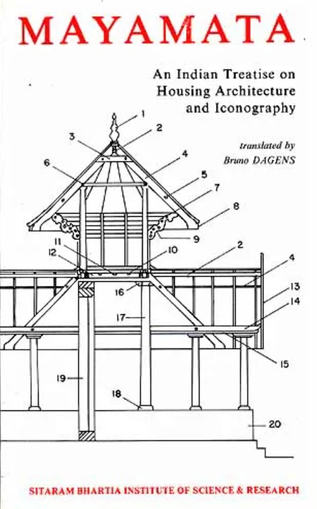
The Mayatama is a Vastusastra, a ‘treatise on dwelling’ dealing with all the facets of gods’ and men’s dwellings, from the choice of a site to the iconography of temple walls. Composed by traditional architects (sthapati) of South India,it contains numerous and precise descriptions of villages and towns as well as of temples, houses, mansions and palaces. It gives indications for the selection of a proper orientation, of right dimensions and of appropriate building materials.
The Mayatama is a Vastusastra, a ‘treatise on dwelling’ dealing with all the facets of gods’ and men’s dwellings, from the choice of a site to the iconography of temple walls. Composed by traditional architects (sthapati) of South India,it contains numerous and precise descriptions of villages and towns as well as of temples, houses, mansions and palaces. It gives indications for the selection of a proper orientation, of right dimensions and of appropriate building materials.
Publications
[based on the bibliography — book reviews not included — by Vincent Lefèvre & Christophe Pottier, “Bruno Dagens (19 février 1935 – 17 septembre 2023)”, BEFEO 110, 2024: 11 – 26.]
Books
[with Marc Le Berre & Daniel Schlumberger], Monuments préislamiques d’Afghanistan (Mémoires de la DAFA 19), Paris, Librairie C. Klincksieck, 1964.
Mayamata, Traité sanskrit d’architecture, édition critique, traduction et notes par Bruno Dagens, 2 vol., Pondichéry, Institut français d’Indologie (Publications de l’Institut français d’Indologie 40 – 1 et 2), 1970 – 1976 .
Les Enseignements architecturaux de l’Ajitāgama et du Rauravāgama (Études sur les āgama śivaïtes I), Pondichéry, Institut français d’Indologie (Publications de l’Institut français d’Indologie 57), 1977.
Le florilège de la doctrine śivaïte — Śaivāgama-paribhāṣāmañjarī de Vedajñāna, édition critique, traduction et notes par Bruno Dagens, Pondichéry, Institut français d’Indologie (Publications de l’Institut français d’Indologie 60), 1979.
Architecture in the Ajitāgama and the Rauravāgama – A Study of two South Indian Texts, New Delhi, Sitaram Bhartia Institute of Scientific Research [rev. tr. of Enseignements architecturaux, 1977], 1984.
Entre Alampur et Śriśailam – recherches archéologiques en Andhra-Pradesh, 2 vol., Pondichéry, Institut français d’Indologie (Publications de l’Institut français d’Indologie 67−1÷2), 1984.
Mayamata: An Indian Treatise on Housing Architecture and Iconography, New Delhi, Sitaram Bhartia Institute of Scientific Research, 1985; New Delhi, IGNCA (Indira Gandhi National Centre for Arts)/ Motilal Banarsidass, 1994, 2 vols [ENG & SK], 978 p. ; rev. ed. New Age Books, 2017.
Préservation des monuments de Vat Phu, Paris, UNESCO, 1986. | ENG Preservation of Wat Phu, Paris, UNDP/UNESCO, 1988.
Angkor, la forêt de pierre, Paris, Gallimard (Découvertes Gallimard 64), 1989. | US ed.: Angkor: Heart of an Asian Empire, , New York, Harry N. Abrams (“Abrams Discoveries” series), 1995. | UK : Angkor: Heart of an Asian Empire, London, Thames & Hudson (‘New Horizons’ series), 1995. | CH : 吳哥窟:失落的石頭之林 [Angkor Wat: The Lost Stone Forest], tr. Ma Hsiang-yang, Taipei, China Times Publishing (Exploration Travels series 71), 2002. ISBN 957−133−934−2. | DE : Angkor: Werk des Königs der Engel.
Cent objets disparus : Pillage à Angkor / One hundred missing objects: Looting in Angkor, Paris, ICOM-EFEO, 1993; rev. ed. 1997.
Le Rauravāgama. Un traité rituel et de doctrine śivaïtes, introduction, traduction et notes par Bruno Dagens et Marie- Luce Barazer-Billoret, 2 vol., Pondichéry, Institut français de Pondichéry (Publications du Département d’Indologie 89 – 1 et 2), 2000.
Les Khmers, Paris, Les Belles Lettres (Guides Belles Lettres des civilisations 10), 2003.
[with Marie-Luce Barazer-Billoret] Shiva, libérateur des âmes et maître des dieux, Paris, Gallimard (Découvertes Gallimard 450), 2004.
Dīptāgama, édition critique par M.-L. Barazer-Billoret, B. Dagens et V. Lefèvre, avec la collaboration de S. Sambhanda Sivacarya, Pondichéry, Institut français de Pondichéry, Vol. I (Collection Indologie 81.1)., 2005; Vol. II (Collection Indologie 81.2), 2007; Vol III [with C. Barois](Collection Indologie 81.3), 2009.
Traités, temples et images du monde indien : études d’histoire et d’archéologie, articles de Bruno Dagens rassemblés par M.-L. Barazer-Billoret et V. Lefèvre, Paris, Presses de la Sorbonne Nouvelle / Pondichéry, Institut français de Pondichéry, 2005.
Anamorphoses, Hommage à Jacques Dumarçay, textes réunis par H. Chambert-Loir et B. Dagens, Paris, Les Indes Savantes, 2006.
Le temple indien, miroir du monde, Paris, Les Belles Lettres, Coll. Réalia 21, 2009. | ENG The Indian Temple – Mirror of the World, New Delhi, Indira Gandhi National Centre for the Arts / New Age Books, 2016.
[with S. Sambandhasivacarya, M.-L. Barazer-Billoret, T. Ganesan, J.-M. Creisméas] Sūkṣmāgama, Critical Edition, Paris, EFEO/Pondichéry, Institut français de Pondichéry, Vol. I: Chapters 1 to 13 (Collection Indologie 114 – 1), 2010; Vol. II: Chapters 14 to 53 (Collection Indologie 114 – 2), 2012; Vol. III: Chapters 54 to 85 (Collection Indologie 114 – 3), 2018.
Traité de l’habitat. Le Mayamata, morceaux choisis introduits, commentés et traduits du sanskrit par Bruno Dagens, illustrations et croquis de Benjamin Van Blancke, Paris, Les Belles Lettres, 2022.
Articles & Contributions
“Fragments de sculpture inédits” et “Monastères rupestres de la vallée de Foladi”, in Bruno Dagens, Marc Le Berre & Daniel Schlumberger, Monuments préislamiques d’Afghanistan, Paris, Librairie C. Klincksieck (Mémoires de la DAFA 19), 1964, p. 9 – 60.
“Étude iconographique de quelques fondations de l’époque de Sūryavarman Ier”, Arts Asiatiques (AA) 17, 1968, p. 173 – 208.
“Étude sur l’iconographie du Bayon (frontons et linteaux)”, AA 19, 1969, p. 123 – 167.
“Un traité d’architecture de l’Inde du Sud, le Mayamata”, École pratique des hautes études. 4e section, Sciences historiques et philologiques, Annuaire 1968 – 1969, 1969, p. 553 – 555.
”Les linteaux décoratifs du Prasat Cha Chouk”, BEFEO 57, 1970, p. 91 – 98.
[with N. R. Bhatt) “I. Analyse du Purvakâmikâgama”, BEFEO 64, 1977, p. 1 – 38.
”Les aspects techniques de l’iconographie selon les āgama śivaïtes”, Indologica aurinensia 13 [Proceedings of the Sixth World Sanskrit Conference, Philadelphia, Oct. 13th-20th, 1984], 1988, p. 29 – 41.
“Les tours du Bayon d’Angkor et le nombre 108”, Bulletin d’Études Indiennes (BEI) 6, 1988, p. 177 – 199.
“Mesures et proportions dans les traités architecturaux indiens”, in Les mesures de l’espaces – Unités de mesure, École d’Architecture de Versailles, 1989, p. 85 – 98.
“Iconography in Śaivāgamas: Description or Prescription?”, in A.L. Dallapiccola (ed.), Shastric Tradition in Indian Arts,Stuttgart, Franz Steiner Verlag, 1989, p. 151 – 153.
“Centralisme et architecture : les hôpitaux de Jayavarman VII dans la Thaïlande du Nord-Est”, in Récentes recherches en archéologie de Thaïlande (Actes du 2ème symposium Franco-Thaï sur l’histoire de la Thaïlande du Nord-Est, 9 – 11 décembre 1991), Bangkok, 1991, p. 24 – 35.
“La découverte d’Angkor”, L’Histoire 153, 1992, p. 84 – 92 [version mise à jour dans “Indochine, Vietnam – Colonisation, guerre et communisme”, Les collections de L’Histoire 23, Apr.-June 2004].
“Māna in the Arts: Architecture and Image-Making”, in Kapila Vatsyayan (ed.), Kalātattvakośa – A Lexicon of Fundamental Concepts of the Indian Arts, vol. II, New Delhi, Indira Gandhi National Centre for the Arts, 1992, p. 367 – 384.
Encyclopaedia Universalis [FR] : articles “Bouddhisme : Représentation du Bouddha” et “Bouddhisme : Représentation des Bodhisattvas” ; révision des articles “Aihole”, “Ajanta”, “Amaravati”, “Angkor”, “Asie du Sud-Est : Art et Archéologie », “Avalokiteśvara”, “Badami”, “Begram”, “Bharhut”, “Bhubaneçvar”, “Bodhgaya”, 1992.
“L’Asie du Sud et du Sud-Est”, in Le grand atlas de l’Art, t. II, Paris, Encyclopaedia Universalis, 1993, p. 292 – 293, 296 – 307, 310 – 315.
“Le temple indien en Asie du sud-est : Archéologie d’une forme”, in François Bizot (ed.), Recherches nouvelles sur le Cambodge, Paris, École française d’Extrême-Orient, 1994, p. 259 – 272.
“Le rôle et la place de Henri Mouhot dans la politique française en Indochine”, in Montbéliard sans frontières – Colloque international de Montbéliard 8 et 9 octobre 1993, Montbéliard, Société d’émulation de Montbéliard, 1994, p. 217 – 231.
“Recherches archéologiques franco-thaï dans la Thaïlande du Nord-Est. Les fouilles de Muang-Champasi”, Comptes rendus des séances de l’Académie des Inscriptions et Belles-Lettres (CRSAIBL) 138 (1), 1994, p. 43 – 67.
“Autour de l’iconographie de Phimai”, in Actes du Premier Symposium franco-thaïlandais : La Thaïlande des origines de son histoire au XVème siècle, Bangkok July 1988, Bangkok, 1995, p. 17 – 37.
“The Sanskrit Treatises of Architecture and Iconography”, in The Dictionary of Art, London, Macmillan Publishers, 1996, vol. 15, p. 208 – 210.
“Le temple corps du dieu”, in Nalini Balbir, Georges-Jean Pinault & Jean Fezas (ed.), Langues, style et structure dans le monde indien – Centenaire de Louis Renou, actes du Colloque international (Paris, 25 – 27 janvier 1996), Paris, Librairie Honoré Champion, 1996, p. 355 – 383.
“Le site de Muang Champasi (Na Dun) – les grandes lignes de son organisation et de son histoire”, in Les apports de l’archéologie à la connaissance des anciens états en Thaïlande (Actes du 3ème symposium franco-thaï, Université Silpakorn 11 – 13 Dec.1995), Bangkok, 1997, p. 39 – 50.
[with J. Dumarçay] “In Memoriam : Denys Lombard (1938−1998)”, AA 53, 1998, p. 96 – 97.
“Le temple et le miroir à travers le monde indien”, in Marie-Luce Barazer-Billoret & Jean Fezas (ed.), La norme et son application dans le monde indien, Paris, École française d’Extrême-Orient (Études thématiques 11), 2000, p. 175 – 192.
“Architecture, espace et temps dans le Cambodge ancien”, intr. to Hedwige Multzer O’Naghten, Architecture et espace sacré dans les temples du Cambodge, Paris, P. Geuthner, 2000, p. 11 – 14.
“Genres, sexes et âges de la vie dans les traités d’architecture et textes apparentés”, in Christine Chojnacki (ed.), Les âges de la vie dans le monde indien, Lyon, CEROR (Collection du Centre d’Études et de Recherches sur l’Occident Romain, N.S. 24), 2001, p. 65 – 92.
“La statuaire khmère au Musée National de Phnom Penh” et “Le Cambodge des origines au 15ème siècle”, in Catalogue du Musée National de Phnom Penh, Paris, École française d’Extrême-Orient / Association française des amis de l’Orient, 2001, p. 13 – 17/ 25 – 38.
“Architettura, arti e tecnica (La scienza indiana, cap. XVIII)”, in Sandra Petruccioli (ed.), Storia della scienza, Roma, Istituto della Enciclopedia Italiana, vol. II, 2001, p. 896 – 907.
“Les tours à visage du Bayon et leur signification”, Final Report of the Fifth Bayon Symposium (Siemreap, 11 – 13 December 2000, Japan Archaeological Association), 2001, p. 83 – 120.
“Temple Architecture in India at the Beginning of the 6th Century According to Varāhamihira’s Bṛhatsaṃhitā”, in Proceedings of the XIth World Sanskrit Conference (Torino 2000), Torino, CESMEO, 2001, CD-Rom.
“Les collections du musée national de Phnom Penh (1970−2002) (note d’information)”, CRSAIBL 146 (2), 2002, p. 699 – 706.
“History of the Angkor Site”, Museum International (Paris, UNESCO) 213 – 214, 2002: 12 – 22.
“Roberto de Nobili et les débuts de l’étude raisonnée de la société indienne par l’Europe”, in Danielle Buschinger & Cécile Leblanc (ed.), Regards occidentaux sur l’Inde, Actes du Colloque international des 1er, 2 et 3 mars 2007 à Amiens, Amiens, Presses du Centre d’études médiévales, Université de Picardie (Coll. “Médiévales” 43), 2007, p. 33 – 40.
“Angkor instrument politique: avant, avec et après le Protectorat”, in Hugues Tertrais (ed.), Angkor viiie-xxie siècle. Mémoire et identité khmères, Paris, Éd. Autrement, 2008: 96 – 109.
“Śiva qui se chausse pour mendier”, in Danielle Buschinger & Arlette Sancery (ed.), Mélanges de langue, littérature et civilisation offerts à André Crépin à l’occasion de son 80eme anniversaire, Amiens, Presses du Centre d’études médiévales, Université de Picardie (Coll. “Médiévales” 44), 2008: 125 – 128.
“N. R. Bhatt (1920−2009)”, BEFEO 95 – 96, 2008 – 9, p. 19 – 25.
“Les animaux dans l’architecture du temple indien. Images et métaphores”, in Nalini Balbir & Georges-Jean Pinault (éd.), Penser, dire et représenter l’animal dans le monde indien, Paris, Librairie Honoré Champion, 2009, p. 333 – 362.
“Le rayonnement culturel de l’Inde en Asie”, in Jean-Luc Racine (ed.), L’Inde et l’Asie. Nouveaux équilibres, nouvel ordre mondial, Paris, CNRS Editions, 2009, p. 49 – 63.
“Mythologie indienne et pouvoir royal dans le Monde indien: l’exemple du Cambodge ancien”, in Danielle Buschinger (ed.), Mythes et mythologies. Actes du Colloque d’Amiens, 6, 7 et 8 mars 2008, Amiens, Presses du Centre d’études médiévales, Université de Picardie (Coll. “Médiévales” 45), 2009, p. 76 – 84.
“Temple indien et milieu naturel: l’exemple du Dīptāgama”, BEI 24 – 25 (2006−2007), rel. 2009, p. 45 – 58.
“La redécouverte d’Angkor et les premières images ou de l’imaginaire aux images”/ “Neak Pean”, in Archéologues à Angkor, Archives photographiques de l’EFEO, Musée Cernuschi, 9 Sept. 2010 — 2 Jan. 2011, Paris, Éd. Findakly, 2011: 19−24÷182−184.
“Un banquet en forêt au Cambodge”, in Danielle Buschinger (éd.), Banquets et convivialité, Actes du Colloque international des 3, 4 et 5 mars 2010, Amiens, Presses du Centre d’études médiévales, Université de Picardie (Collection “Médiévales” 46), 2011, p. 39 – 42.
“Avant-Propos”, in S. Sambandan & T. Ganesan, Sūkṣmāgama, Vol. I, Chapters 1 to 13, Pondichéry, EFEO (Collection Indologie 114.1), 2011, p. iii‑v.
“Avant-propos”, in Nadine Dalsheimer-Van der Tol, Le corps des dieux. Contribution à l’étude de la formation de l’art khmer, Paris, L’Harmattan, 2011, p. 11 – 15.
[with T. Ganesan] “Transmission of Manuscripts, Rewriting & Interpretation: The case of Saivâgama‑s in South India”, in Nalini Balbir & Maria Szuppe (ed.), Lecteurs et copistes dans les traditions iraniennes, indiennes et centrasiatiques / Scribes and readers in Iranian, Indian and Central Asian Manuscript Traditions, Rome, Istituto per l’Oriente C.A. Nallino (Eurasian Studies XII/1 – 2), 2014, p. 11 – 21.
[with Gavin Flood],“Tantric Studies: Introduction”, Journal of Hindu Studies 8 – 2, 2015: 163 – 169.
“Les vagabondages de la tombe du Bouddha”, in Florent Gabaude, Jürgend Kuhnel & Mathieu Olivier (ed.), Études offertes à Danielle Buschinger par ses collègues, élèves et amis à l’occasion de son 80eme anniversaire, Amiens, Presses du Centre d’études médiévales, Université de Picardie (Coll. “Médiévales” 60), 2016: 283 – 291.
« Srivijaya : empire ou emporium ? une étude de cas de l’orientalisme », by Nicole Biros, 1992.
« L’oeuvre scientifique française en Afghanistan (1922−1982) », by Françoise Olivier-Utard, 1992.
« Les superstructures couvrantes dans l’architecture du Cambodge ancien : formes et techniques », by Bruno Bruguier, 1994.
« Population divine dans les temples, religion et politique sous Jayavarman VII », by Christine Hawixbrock, 1994.
« L’Indochine : un lieu d’échange culturel ? les peintres français et indochinois (fin xixe-xxe siècles). Inventaire et description de leurs oeuvres replacées dans le contexte historique, social et artistique », by Nadine André-Pallois, 1995
« Les débuts des cultes krishnaïtes dans la région de Mathurā », by Charlotte Schmid, 1996.
« Le corps des dieux, la plastique dans la statuaire khmère et ses relations avec celle des pays voisins », by Nadine Dalsheimer-Van der Tol, 1997.
« Le bouddhisme en Sogdiane d’après les données de l’archéologie (ive-ixe siècles) », by Nathalie Lapierre, 1998.
« La grande fête du temple (mahotsava) d’après les āgama śivaïtes », by Marie-Luce Barazer-Billoret, 1999.
« Les temples excavés de la colline de Po Win en Birmanie centrale : architecture, sculptures et peintures murales », by Anne-May Chew, 1999.
« L’iconographie des pavillons d’entrée des sanctuaires au Tamilnad (Inde du Sud) a partir du viie siècle de notre ère », by Martine Delaruelle, 1999.
« L’architecture et la sculpture à Sāñcī, Madhya Pradesh, Inde, iiie s. av. J.-C. — xie s. apr. J.-C., reconsidérées à la lumière des recherches récentes sur l’art indien », by Sandrine Gill, 2000.
« Carte archéologique de la région d’Angkor zone sud », by Christophe Pottier, 2000.
« L’architecture de Pagan (Birmanie) : ses sources et ses particularités », by Vanessa Duchemin, 2001.
« Architecture et iconographie des temples de Viṣṇu dans la vallée de Kathmandu, Népal », by Anne-Claire Juramie, 2001.
« L’iconographie de Maitreya (Bodhisattva et Buddha futur) de l’Inde à l’Asie du Sud-Est », by Jirassa Kachachiva, 2001.
« Histoire architecturale du Baphuon », by Pascal Royère, 2002.
« La création artistique au Tamiḻ Nāḍu (vie-xviiie siècle) : le commanditaire et l’artiste », byr Vincent Lefèvre, 2004.
« Maṇḍala et cycles méditatifs dans les Yogatantra : étude et traduction du Sarvatathāgatattvasaṃgraha (Partie I) », by Jean-Pascal Pillot, 2004.
« L’immagine dell’India nel medioevo italiano : arte e letteratura », by Maria Francesca Tagliatesta, 2005.
« Les derniers siècles de l’époque angkorienne au Cambodge [env.1220 – env.1500] », by Ludivine Provost-Roche, 2010.
References
Bruno Dagens, Traités, temples et images du monde indien : études d’histoire et d’archéologie, articles rassemblés par M.-L. Barazer-Billoret et V. Lefèvre, Paris, Presses de la Sorbonne Nouvelle / Pondichéry, Institut français de Pondichéry, 2005.
Marie-Luce Barazer-Billoret, “Introduction : De Kaboul à Pondichéry via Angkor”, Bulletin d’Études Indiennes 33 (De l’Inde au Cambodge. Hommage à Bruno Dagens, textes réunis par Marie-Luce Barazer-Billoret), 2015: 3 – 10.
Photo: Bruno Dagens at Darusaram Temple, Jan. 2010 (source: BEFEO 2024, op. cit.)
sk लिङ्ग linga, 'penis', 'grammatical gender', 'mark', 'sign', 'a type of ancient temple' | kh លិង្គ lengk 'gender', 'feature', 'attribute', 'male genitalia'
The liṅga is a semi-iconic (between the iconic and the aniconic) image of Śiva. A cylindrical shaft with phallic connotations, it is often associated to the yoni, symbolic representation of the female genitalia, the matrix of anything [1].
The linga symbol is ever-present in Southeast Asian architecture and religious representations. It has absorbed ancient local cults of uncut stones. Associated with fertility rituals in Cambodia, it became the physical embodiment of the kamraten jagat raja or devaraja, the vector of the divine essence attached to kingship.
[1] In Tibetan Vajrayana (tantric Buddhism), 'liṅga' refers to the “upper genitals” [penis or clitoris].
Sahasraliṅga (सहस्रलिङ्ग) is a multiple man-made linga formation of anamorphic or anthropomorphic statues (at times on top of a yoni), or of images carved in natural rock wall and bed, usually for the purification and consecration of water.
Sahasralingas are associated with Saivism but can include representations of Brahma and Vishnu.
The Kbal Spean ក្បាលស្ពាន Thousand-Lingaលិង្គ១០០០ site on the Siem Reap River, Cambodia, is a typical example of 'passive consecration' of running water.
At Prambanan temple (Java, Indonesia), collected rainfall goes underground through bulbous forms (lingas) as a "holy water machine", to use the phrase coined by Jeffrey Sundberg in 2022, around cellas hosting giant (3 meters high) monolithic images of Shiva, Brahma and Vishnu, all mounted on 1-meter high yonis.
In the Purana, Sahasralinga isthe name of an ancient lake constructed by king Siddharāja Jaysiṃha from Anahillapur Patan (Gujarat). Sahasralinga or Sahastralinga is also a pilgrimage place on the Shalmala River near the town of Sirsi, Uttara Kannada (Karnataka state), India.