Here, we have excerpts of the official report to the French Ministry of the Navy and Colonies by vice-admiral Bonard, then both Governor and Commander-in-chief of the French military in Cochinchina, on “an exploration led in September 1862 by the latter aboard L’Ondine gunboat on the Cambodia River, which the Annamites call the Great-River.”
A military man involved in ruthless campaigns against Cochinchinese, Cambodian and Vietnamese insurgents, the author mostly use Vietnamese toponyms for Cambodian towns, rivers and lakes, except for Houdon (Oudong), Panom Peign (Phnom Penh, also with the Vietnamese name Nam-Vang), and Bassac. His map can be usefully compared with the one drawn eleven years earlier, in 1851, for the commercial mission to Cambodia organized by L.V. Helms.
We start with his description of Angkor, published shortly after Henri Mouhot’s famous ‘rediscovery’, and before the Mekong Exploration Commission reports. Once again, Bonard’s take on Cambodia was essentially marked by military strategy considerations, yet he could not hide his emotion at discovering the ruins in the jungle with his own eyes.
Angkor
Le royaume du Cambodge, qui n’est plus qu’un amas de débris, a été un grand empire ; l’industrie et l’agriculture ont dû y être développées sur une grande échelle : les témoins de ce que j’avance sont encore debout, protestant contre l’incurie des hommes. A une heure d’Àncor [Angkor], qui n’est qu’une forteresse très-peu fortifiée, sinon par les vases dont elle est entourée, dans laquelle on né peut pénétrer par terre dans cette saison que [ par une chausséede plus d’une lieue entre des marais noyés, après avoir vu de tous côtés ces cases éphémères servant d’abri à la population, on est surpris, ébloui du spectacle inattendu qui s’offre tout à coup à la vue.
Un grand carré de 100 mètres de côté, dallé en pierres de taille larges et parfaitement jointes, ayant aux différents angles des simulacres de lions en pierre dont un ou deux seulement sont en assez bon état, vous mène à une porte colossale ouverte dans une muraille également en pierres de taille, qui se prolonge à perte de vue dans les touffes de la luxuriante végétation au milieu de laquelle on se trouve. La porte donne entrée sur une large jetée en belles pierres de taille, bordée des deux côtés par une balustrade en pierres dont il né reste que des débris. Au milieu de cette jetée, des deux côtés, sont deux petits temples, également en pierres de taille et couverts de ciselures ressortant parfaitement partout où la pluie n’a pas fait de ravages.
Cette jetée, qui a deux cents mètres de long à peu près, est entourée des deux côtés par deux vastes bassins que la végétation tropicale a envahis, mais dont la forme gigantesque et le beau travail peuvent encore parfaitement se juger. En parcourant cette jetée, on a en perspective un vaste l édilice tout en belles pierres de taille ayant plus de deux cents mètres de développement, dominant le sol par un soubassement de même nature. Des colonnes torses garnissent toutes les fenêtres, ouvertes sur une seconde galerie. Les fenetres et les portes sont enjolivées par les sculptures les plus fraîches et les plus gracieuses ; les toits, également en pierres de taille, se relient gracieusement à l’édifice qu’ils couronnent par de petits pavillons ou belvédères couverts d’une immense quantité de sculptures et de guipures qui mettent le tout dans une harmonie parfaite.
Un péristyle de vingt marches conduit au pavillon du centre. En le traversant, on arrive à une cour analogue à la première, comprenant chaussée et bassins. La chaussée aboutit à un second escalier ; le tout est entouré de cellules dont les portes et les fenêtres sont couvertes de sculptures sur pierre d’une admirable exécution. La seconde façade né diffère guère de la première ; même luxe d’ornementations et de sculptures, même élévation au-dessus du plan du premier édifice. On voit qu’en y pénétrant, on voulait inculquer au fidèle, matériellement, qu’il allait passer à un degré d’initiation plus élevé.
Du pavillon du second édifice, on passé dans la cour, identique pour la forme, au troisième édifice. Mais ce dernier, tout en conservant la forme des précédents, les domine par l’énorme élévation de son soubassement qui force à monter près de cent marches pour parvenir à son pavillon central. De plus, le nombre des enjolivements, des sculptures, des clochetons ouvragés dominant le faîte de l’édifice, surpasse de beaucoup ceux que l’on a dû visiter avant de pouvoir y arriver.
Chacun de ces édifices est semé de chapelles où se trouvent les statues consacrées à l’ancien culte de Bouddha. Quelques unes subsistent encore, quoique mutilées. Cependant une ou deux de ces chapelles sont en assez bon état. On y trouve aussi une espèce de musée bouddhique, où sont accumulés des débris d’objets de ce culte et que fréquentent quelques bonzes, ombres de ceux qui ont eu la puissance nécessaire pour créer une merveille du genre de cet admirable édifice.
Il faudrait du temps et des connaissances que je né possède pas pour mettre à jour tout ce qu’il y a de curieux pour l’histoire de ce pays dans les inscriptions, sculptures et bas reliefs qui couvrent tout cet immense édifice, égale au moins en développement au Louvre et aux Tuileries réunis. Je né puis que signaler ce que j’ai vu, sans en donner l’explication, mais je né saurais nier que je me suis senti bien ému en voyant du haut de cette dernière pagode d’initiation cette immense construction, communiquant par quatre portes au désert. Du haut de cette pagode, je découvrais un immense et fertile pays où la nature seule a repris ses droits, où l’homme n’est plus rien aujourd’hui par sa faute.
Sous ses immenses galeries de plus de 200 mètres chacune, ayant en grande partie victorieusement résisté aux injures du temps, grâce à la solide construction de l’édifice, dont les pierres sont joinles à l’émeri, on voit, outré, les guipures et sculptures dignes d’être comparées aux travaux les plus délicats du Louvre, se dérouler trois rangées de bas reliefs très-bien conservés et aussi nets que s’ils sortaient de la main de l’ouvrier habile qui les a faits, et cela sur un espace de 10 mètres de hauteur sur 800 à 1000 mètres de longueur.
La légende de l’histoire, la religion de ce peuple disparu est là entièrement exposée aux yeux des incrédules, qui né pourront plus nier que le misérable Cambodged’aujourd’hui a nourri et peut nourrir encore un grand peuple artiste et industrieux. Ils né pourront plus le nier, lorsqu’ils verront ce qui a été fait, il y a quelques milliers d’années, dans ce pays favorisé par la nature et où les hommes seuls ont changé.
[“A large square of 100 meters on each side, paved with large and perfectly joined cut stones, having at different angles simulacra of stone lions, only one or two of which are in fairly good condition, leads you to a colossal door open in a wall also made of cut stone, which extends as far as the eye can see into the tufts of lush vegetation in the middle of which we find ourselves. The door opens onto a wide pier made of beautiful cut stones, bordered on both sides by a stone balustrade of which only debris remains. In the middle of this pier, on both sides, are two small temples, also made of cut stone and covered with carvings standing out perfectly wherever the rain has not wreaked havoc.
This pier, which is approximately two hundred meters long, is surrounded on both sides by two vast basins invaded with tropical vegetation, but whose gigantic shape and fine workmanship can still be perfectly grasped. Walking along this pier, we see a vast edilice made of beautiful cut stones measuring more than two hundred meters in length, dominating the ground with a base of the same nature. Twisted columns adorn all the windows, opening onto a second gallery. The windows and doors are embellished with the freshest and most graceful sculptures; the roofs, also made of cut stone, connect gracefully to the building which they crown with small pavilions or belvederes covered with an immense quantity of sculptures and guipures which bring everything into perfect harmony.
A peristyle of twenty steps leads to the center pavilion. Crossing it, we arrive at a courtyard similar to the first, comprising a causeway and ponds. This leads to a second staircase; the whole is surrounded by cells whose doors and windows are covered with stone sculptures of admirable execution. The second façade hardly differs from the first; same luxury of ornamentation and sculpture, same elevation above the plan of the first building. We see that by entering it, one wanted to concretely inculcate in the faithful that he was going to move on to a higher degree of initiation.
From the pavilion of the second building, we pass into the courtyard, identical in form, to the third building. But the latter, while retaining the shape of the previous ones, dominates them by the enormous elevation of its base which requires one to climb nearly a hundred steps to reach its central pavilion. In addition, the number of embellishments, sculptures, ornate pinnacles dominating the peak of the building far exceeds those that we had to visit before being able to get there.
Each of these buildings is dotted with chapels where there are statues dedicated to the ancient cult of Buddha. Some still remain, although mutilated. However, one or two of these chapels are in fairly good condition. There is also a kind of Buddhist museum, where debris of objects of this cult are accumulated and which are frequented by a few monks, shadows of those who had the power necessary to create a marvel of the type of this admirable building.
It would take time and knowledge that I do not possess to bring to light everything that is curious about the history of this country in the inscriptions, sculptures and bas reliefs which cover this entire immense building, equal to — at least in development — to the Louvre and the Tuileries combined. I can only report what I saw, without giving an explanation, but I cannot deny that I felt very moved when seeing this immense construction from the top of the last initiation pagoda, communicating through four doors with the emptiness. From the top of this pagoda, I discovered an immense and fertile country where nature alone has regained its rights, where man is nothing today through his own fault.
Under its immense galleries of more than 200 meters each, having largely victoriously withstood the ravages of time, thanks to the solid construction of the building, whose stones are joined to the emery, we see, in addition, the guipures and sculptures worthy of being compared to the most delicate works of the Louvre, unfold three rows of bas reliefs very well preserved and as clear as if they came from the hand of the skillful worker who made them, and this on a space 10 meters high and 800 to 1000 meters long.
The legend of history, the religion of this vanished people is there entirely exposed to the eyes of unbelievers, who will no longer be able to deny that the miserable Cambodia of today has nourished and can still nourish a great artistic and industrious people. They will no longer be able to deny it when they see what was done, a few thousand years ago, in this country favored by nature and where only men have changed”.”]
fron L.A. Bonard, “Exploration du Grand Fleuve du Cambodge, RMC, 1863
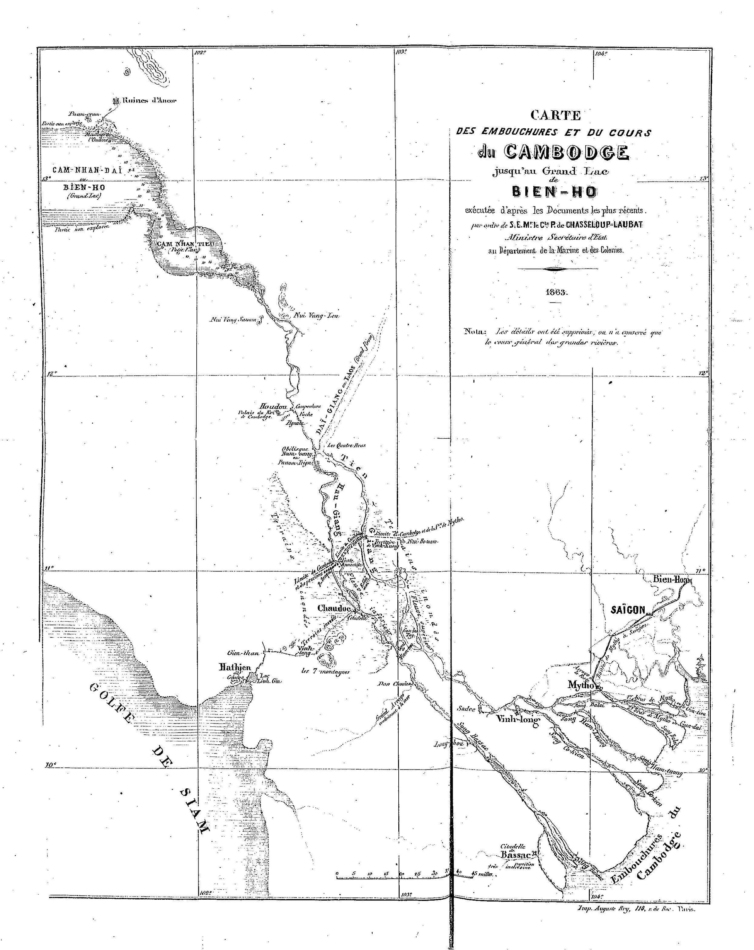
“Map of the Cambodia River from its estuaries to the Great Lake Bien-Ho”.
River, Canals, Lake and Delta
To define the ‘Cambodia’ or ‘Great’ River course, the author resorted to the distinction between Tien-Giang (‘Upper River’) and Hau-Giang (‘Lower River), starting at Nam-vang or Panom Peign (Phnom Penh, here defined by its “Obelisk”, the Wat Phnom Stupa). Upriver, it is called “Dai-Giang (Great River) or Laos”.
The hydrography of the river from Phnom Penh to the sea was to be later fine-tuned by French writers. For instance, in Le monde pittoresque et monumental: L’Extreme-Orient (1887, p. 76), Paul Bonnetain stated:
1) avant d’arriver aux Quatre-Bras : le Ton-té-lock (petit fleuve), qui se divise lui-même en bras destinés à rejoindre soit le Fleuve Antérieur, soit (par un canal) le Vaïco cochinchinois ; 2) à Pnom-Penh : trois cours d’eau, le premier remonte vers le lac Tonlé-Sap ou Grand-Lac ; le second, qu’on nomme Fleuve Supérieur ou Antérieur et le troisième Fleuve Inférieur ou Postérieur, entrent bientôt en Cochinchine. Le Fleuve Supérieur, large cle 600 mètres, passé alors à Barang, Canlo, Tandong, près de Sadec, à Hoa-loc, et à Vinh-long, où il se subdivise en divers bras qui arrosent, entre autres postes, Tranbang, Mytho, Bentré, etc. Le Fleuve Inférieur (le plus occidental) baigne Chaudoc, Longxuyen, Thôt-nôt, Can-tho, etc., passé près de Bactrang et se décharge par le Bassac. Il est relié au golfe du Siam par les canaux de Hatien et de Rach-gia. Le premier seul est navigable en toute saison par des batiments de faible tonnage.
[“1) before reaching Quatre-Bras: the Ton-té-lock (small river), which itself divides into arms intended to join either the Anterior River, or (via a canal) the Cochinchinese Vaïco; 2) in Pnom-Penh: three watercourses, the first goes up towards Lake Tonlé-Sap or Grand-Lac; the second, which we call the Upper or Anterior River, and the third Lower or Posterior River, soon enter Cochinchina. The Upper River, 600 meters wide, then passes Barang, Canlo, Tandong, near Sadec, Hoa-loc, and Vinh-long, where it is subdivided into various branches running through, among other places, Tranbang, Mytho , Bentre, etc. The Lower River (the westernmost) runs the length of Chaudoc, Longxuyen, Thôt-nôt, Can-tho, etc., passes near Bactrang and discharges through the Bassac. It is connected to the Gulf of Siam by the Hatien and Rach-gia canals. The first alone is navigable in all seasons by low tonnage vessels.”]
As for the above-mentioned Mekong Delta canals, Bonard dismissed their potential importance as commercial hubs, probably for one simple reason: the French military planned to deprive Cambodia of any access to the sea, apart from Kampot. He wrote:
Quant à Chaudoc, citadelle assez peu forte au milieu de terrains marécageux, qui peut être battue par des navires au mouillage, elle a une grande importance pour les Annamites, en ce que cette citadelle se relie avec Ha-tien par le canal appelé par plusieurs géographes canal de Cancao, et, de plus fournit les petites garnisons échelonnées le long de ce canal, destinées à contenir les incursions des Cambodgiens sur le territoire annamite. Tous ces postes et cette citadelle, situés au milieu des marais, né sont habitables d’une manière permanente que par des hommes qui sont nés dans le pays. Ils pourraient être facilement enlevés si le besoin s’en faisait sentir; mais leur occupation permanente par des troupes européennes né pourrait avoir lieu qu’avec de grandes pertes d’hommes causées par les maladies, et de grandes dépenses d’installations. La citadelle de Ha-tien, chef-lieu de la province de ce nom, la plus pauvre de la Cochinchine, voisine de Chaudoc, est située sur le golfe de Siam. Elle est désignée sur quelques cartes, comme le canal qui la traverse, sous le nom de Cancao. L’importance que quelques personnes ont cru devoir donner à ce canal et à cette ville est loin d’exister. La rade, située sur le golfe de Siam, est très-mauvaise en toute saison, dangereuse dans la mousson du S.O. Les navires sont obligés de mouiller à de grandes distances, et né peuvent communiquer qu’au moyen de jonques du pays. Il en est de même pour le canal dit de Cancao, passant au pied de la citadelle de Chaudoc; ce n’est qu’exceptionnellementet avec de grandes difficultés qu’un petit navire comme la canonnière que j’y ai envoyée peut communiquer dans le moment de la grande crue des eaux. La carte jointe à ce rapport montre que le canal de Cancao n’a réellement d’importance que comme limite naturelle, pouvant arrêter les incursions des Cambodgiens sur le territoire annamite.”
[“As for Chaudoc, a rather weak citadel in the middle of marshy ground, which can be beaten by ships at anchor, it has great importance for the Annamites, in that this citadel is connected with Ha-tien by the canal called by several geographers ‘Cancao Canal’, and moreover provides for the small garrisons spread along this canal, intended to contain the incursions of the Cambodians on the Annamite territory. All these posts and this citadel, located in the middle of the marshes, are only permanently habitable by men who were born in the country. They could be easily removed if the need arose; but their permanent occupation by European troops could only take place with great losses of men caused by diseases, and great expenses for facilities. The citadel of Ha-tien, capital of the province of that name, the poorest in Cochinchina, neighboring Chaudoc, is located on the Gulf of Siam. It is designated on some maps, like the canal that crosses it, under the name of Cancao. The importance that some people believed should be given to this canal and this city is far from being real. The harbor, located on the Gulf of Siam, is very bad in all seasons, dangerous in the SW monsoon. Ships are obliged to anchor at great distances, and can only communicate by means of local junks. It is the same for the so-called Cancao canal, passing at the foot of the Chaudoc citadel; It is only exceptionally and with great difficulty that a small ship like the gunboat that I sent there can communicate at the moment of great flood waters. The map attached to this report shows that the Cancao Canal is only really important as a natural boundary, capable of stopping Cambodian incursions into Annamite territory.”
In contrast, Bonnetain (op.cit., p. 118) noted in 1887:
Pour finir, il faut citer parmi ces arroyos, le canal de Vinh-té, oeuvre de Gia-Long et de son fils Minh-Mang; le canal de Rach-gia, autre création de Gia-Long; le Vamnao qui fait communiquer les deux bras du Mékong; l’arroyo de la Poste, le plus fréquenté de tous, qui va de Mytho à Tanan et réunit au Mékong le Vaïco occidental; le canal Commercial, ou canal de Dang-giang qui, nettoyé et dragué, relierait Vingh-Long à Cholen [Cholon]; enfin, l’Arroyo chinois, canalisé en 1820, qui rattache Cholen à la rivière de Saïgon et à Mytho.
[“Finally, we must mention among these arroyos, the Vinh-té Canal, work of Gia-Long and his son Minh-Mang; the Rach-gia canal, another creation of Gia-Long; the Vamnao which connects the two arms of the Mekong; the Arroyo de la Poste, the busiest of all, which runs from Mytho to Tanan and joins the western Vaïco to the Mekong; the Commercial Canal, or Dang-giang Canal which, cleaned and dredged, would connect Vingh-Long to Cholen [Cholon]; finally, the Chinese Arroyo, made into a canal in 1820, which connects Cholen to the Saigon River and to Mytho.”]
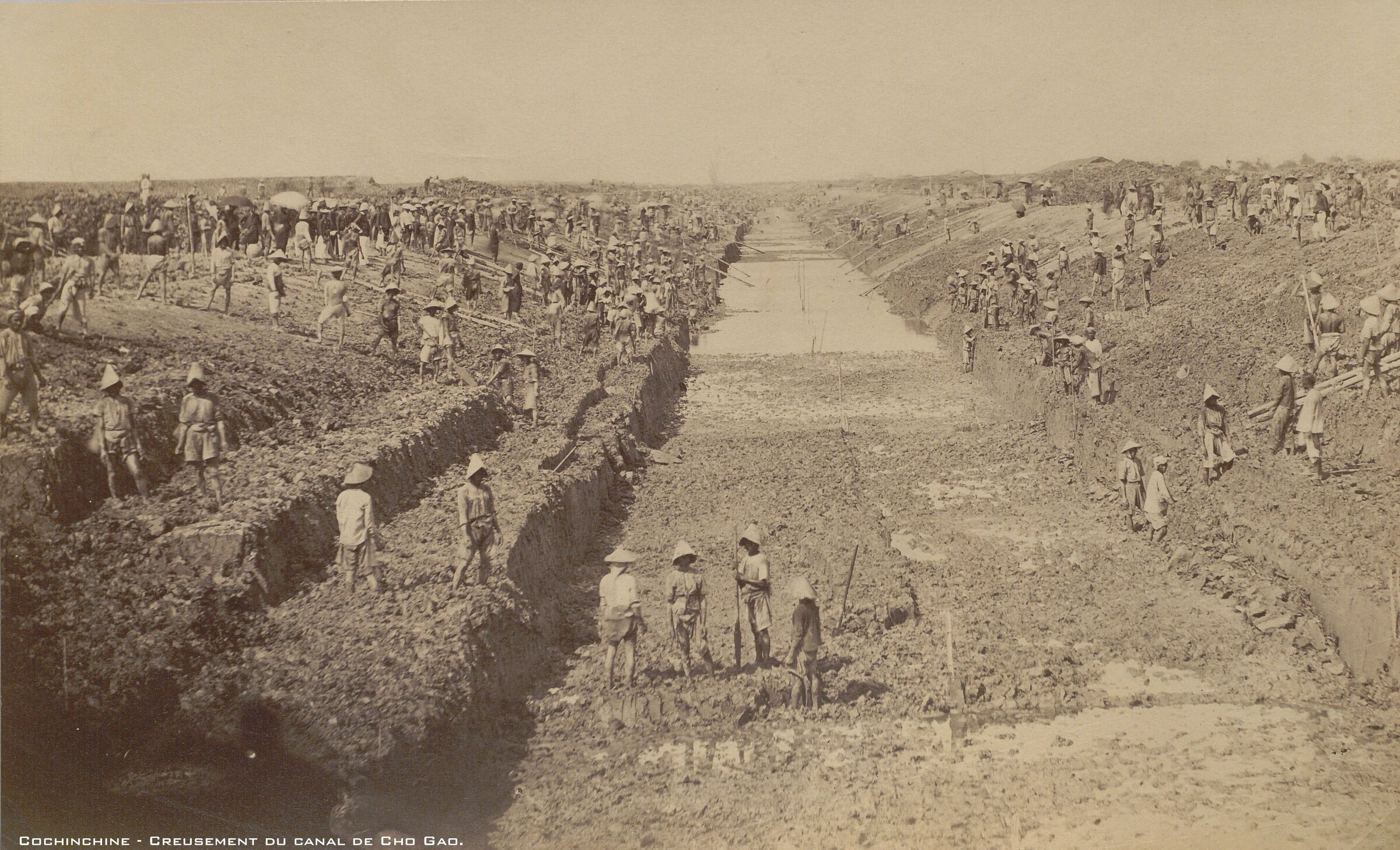
Thet ‘Commercial Canal’ was the Chợ Gạo Canal, grandly inaugurated in 1877 by the French administration but never a success, as it quickly became a marshy wetland. Construction work photographed by Emile Gsell c. 1875.
Thet ‘Commercial Canal’ was the Chợ Gạo Canal, grandly inaugurated in 1877 by the French administration but never a success, as it quickly became a marshy wetland. Construction work photographed by Emile Gsell c. 1875.
As for the Tonle Sap Lake, Bonard reports ‘Pnom-crom’ (Phnom Krom) and ‘Ruines d’Ancor’ (in his eye they are just that, magnificient ruins) to the north, and uses exclusively the Vietnamese designation: Cam Nhan Dai or Bien-Ho (Great Lake) — note that there is a lake called Biển hồ in modern Vietnam, a popular destination near Pleiku — and Cam Nham Tieu (Smaller Lake).
L.A. Bonard for French Minister of the Navy and Colonies, 1867 [gallica.bnf.fr]
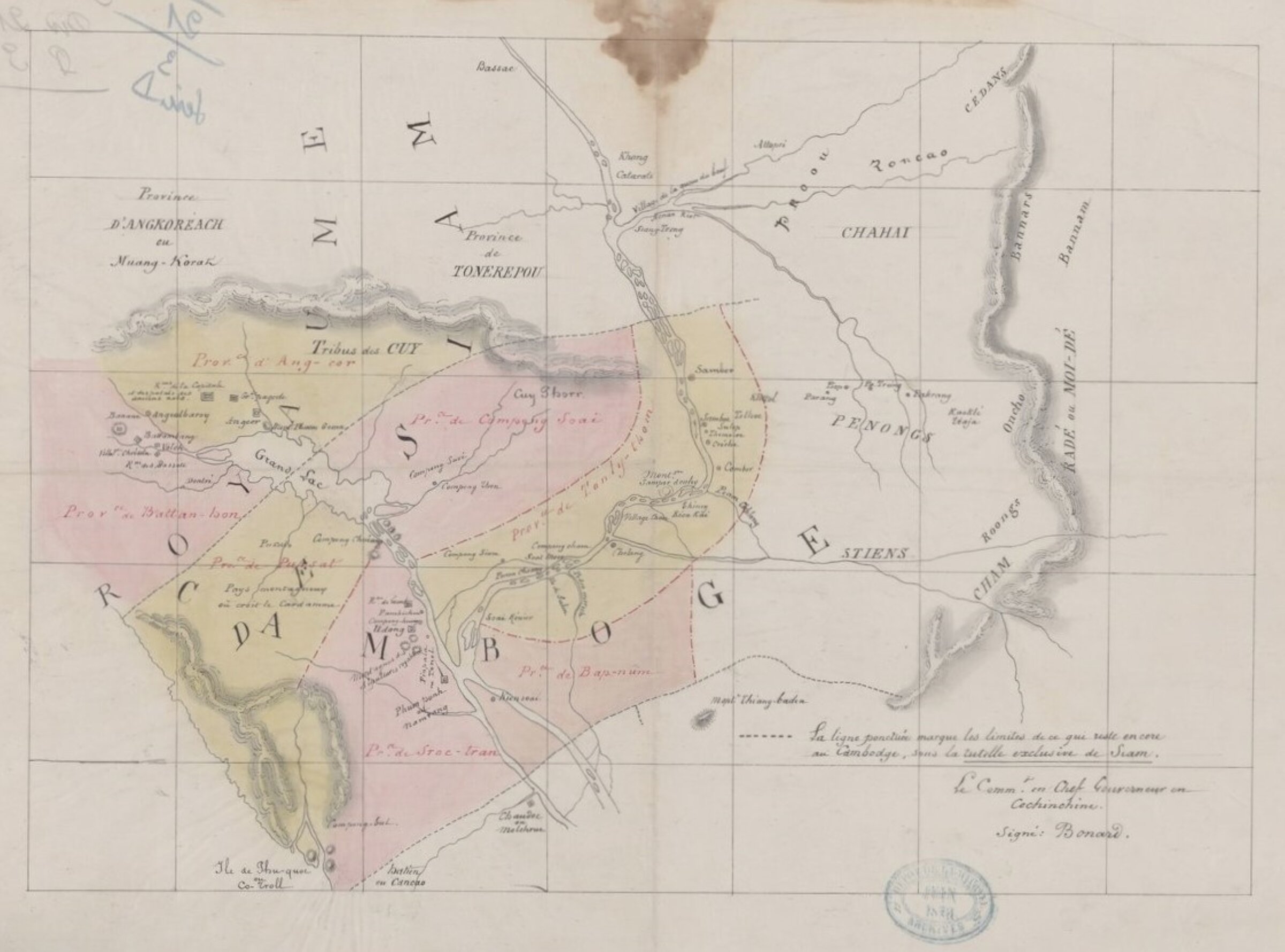
French borders of the Kingdom of Cambodia, with tribe names, 1864 Map approved by L.A. Bonard (source:gallica.bnf.fr)
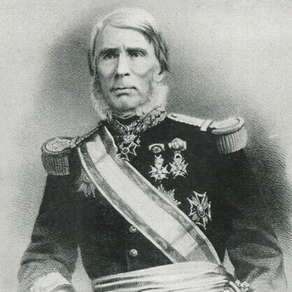
Louis Adolphe Bonard [or Bonnard] (27 March 1805, Cherbourg, France — 31 March 1867, Vanves, France) was a French naval officer who was governor of Cochinchina from 1861 to 1863 and, while campaigning against the insurrections, visited Angkor in September 1962.
A graduate of École Polytechnique in 1825, he served in Mediterranean Sea and was aboard the Silène when the warship was wrecked on the Algerian coast in the night of 14 – 15 May 1929, during the French invasion of Algiers. Shackled and imprisoned by the defenders of Algiers, he was freed from his captors and pursued his career aboard the Sphynx, the Palinure, the Grenadier and the Docouédic in South and East Mediterranean, coming back to North Africa in 1834 as harbour master in Mers El Kébir, Oran, and as the captain of the Iris in 1838, and of the Volage in 1840 – 2.
Made an Officer of the Legion of Honour in 1844 (Commander in 1856, Grand Officer in 1864), Bonard then was second in command of the Uranie in the Pacific, claiming Bora Bora against the British Navy in 1845. He was active during the Franco-Tahitian War (1844 – 1847), fighting the anti-colonial forces of Queen Teriitaria II. According to the blog Tahiti Info, he helped in the development of the new species of Tahitian vanilla, Vanilla xtahitensis, by bringing in cuttings from the Philippines, along with Admiral Ferdinand Alphonse Hamelin (1796−1864), who was to become French Minister of the Navy.
After commanding the naval subdivision of Oceania and returning to France in 1852, Bonard served as Governor of French Guiana from December 1853 to December 1855, when a bout of yellow fever forced him to sail back to France again, where he was promoted to the rank of contre-amiral (counter admiral) and appointed major general of the navy at Brest. He was commander of the naval stations of the western coasts of America and Oceania from 1857 to 1860.
Commander-in-chief ot the French forces in Cochinchina since 29 Nov. 1861, he was officially the first Governor of Cochinchina, capturing the provinces of Biên Hòa and Vĩnh Long, and securing the 5 June 1862 Treaty of Saigon in which Vietnamese emperor Tự Đức recognized the French rule over the provinces of Gia Định, Định Tường and Bien Hoa, as well as Poulo Condore (Côn Đảo) Island — the treaty was also signed by Colonel Palanca, representative of the Queen of Spain.
In September 1862, he visited the ruins of ‘An-cor’ [Angkor]. The year after, on 1 May 1863, he was succeded by Admiral Pierre-Paul de La Grandiere, who sent Navy officer Doudart de Lagree to the Angkor site. The note he sent to the Ministry of the French Navy and Colonies in November 1864, “Memoire sur l’urgence de l’exploration du fleuve le Me-kong, pour créer dans la Cochinchine française, à Saïgon, un entrepôt du commerce avec le Thibet et les provinces occidentales de la Chine” (Ministère de la Marine, dir. des Colonies, carton ‘Cambodge’, dossier n° 1), was a major enabling factor for the 1866 – 8 Mekong Exploration Commission.
Promoted to vice admiral on 25 June 1862, Bonard took charge of the urban development of Saigon (now Ho Chi Minh Ville), promoted the teaching of Vietnamese and French languages, he tried to find a balance of power between French colonial forces and Annamese mandarins, without much success.
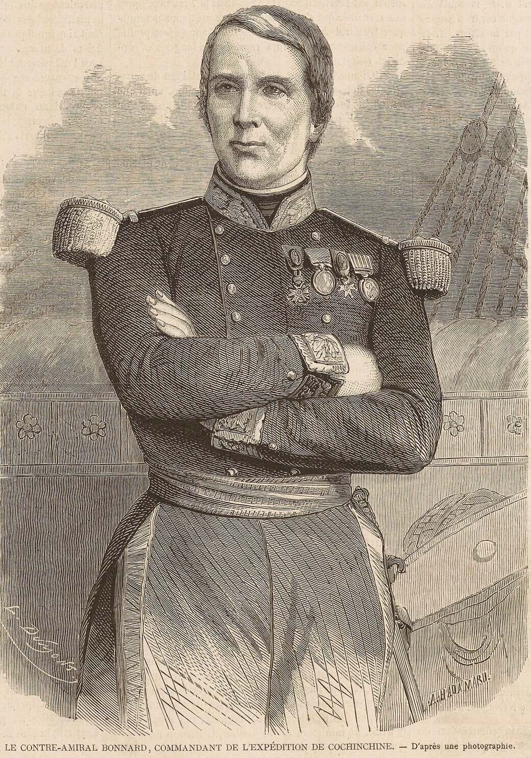
Bonard (Bonnard) pictured on the cover of the French periodical L’Illustration-Journal Universel, 1st March 1862, a few months before his visit to Angkor. [source: gallica.bnf.fr]
Bonard (Bonnard) pictured on the cover of the French periodical L’Illustration-Journal Universel, 1st March 1862, a few months before his visit to Angkor. [source: gallica.bnf.fr]
sk स्तूप, stupa, "heap" | pa thupa | kh ចេតិយ chedi, cha-dey | th เจดีย์ cedyi, "stupa", "mausoleum".
A Buddhist mound-like or hemispherical structure containing relics, originally from the Buddha or from Buddhist monks or nuns, in modern times the remains of distinguished departed people, where one can come to meditate.
Thought to be derived from the ancient ritual of building tumuli, the stupa was designed to allow circumambulation [pradakhshina] around the structure, as seen until these days at Shewanagon Pagoda (Myanmar), the Abayagiri Dageba (Sri Lanka) or Borobodur Temple (Indonesia).
In Cambodia, royal stupas in pagodas (Oudong, Wat Ounalom, Wat Phnom...) and at the Royal Palace (Kantha Boppha chedi, King Suramarit...) have a distinctive style, different from Thai cedyis. In Khmer, the word originally meant "sign" [of a sacred place], and went to refer only to a structure containing relics.