No, it's a 'channel', an artificial watershed, reply the authors, but...it became a river in modern era. And we add new perspectives for this channel-river.
It is safe to say that, historically and even in modern times, Stung Siem Reap, the Siem Reap River, has been two rivers at once: the one, sacred and mysterious, flowing from the Kulen plateau to Kbal Spean and the ‘Thousand Linga’ site; and a second one, domesticated, used as one of the main water feed channels for the vast and complex hydraulic system of Angkor.
In this study, the authors assert that the future of the river depends on the choices in water management for Angkor Archaeological Park. And some 15 years after its publication, the assessment is even more obvious:
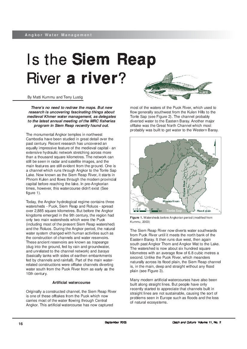
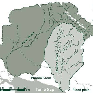
Originally a constructed channel, the Siem Reap River is one of these offtakes from the Puok which now carries most of the water flowing through Central Angkor. This artificial watercourse has now captured most of the waters of the Puok River, which used to flow generally southwest from the Kulen Hills to the Tonle Sap. The channel probably diverted water to the Eastern Baray. Another major offtake was the Great North Channel which most probably was built to get water to the Western Baray.
The Siem Reap River now diverts water southwards from Puok River until it meets the north bank of the Eastern Baray. It then runs due west, then again south past Angkor Thom and Angkor Wat to the Lake. The watershed is now about six hundred square kilometres with an average flow of 6.8 cubic metres a second. Unlike the Puok River, which meanders naturally across its flood plain, the Siem Reap channel is, in the main, deep and straight without any flood plain. Many modern artificial watercourses have also been built along straight lines. But people have only recently started to appreciate that channels built in straight lines are not sustainable, causing the sort of problems seen in Europe such as floods and the loss of natural ecosystems.
And they concluded:
Although the Siem Reap River was originally a human-built channel and not a river, it has become a river over the past thousand years with small meanders and its own unique ecosystem. It will never be a typical river for the area but it is now more of a river than a channel. So it does not have to be renamed “Siem Reap Channel” on maps of the present Angkor area.
Watersheds in Angkor and Siem Reap area before and after human impact on their courses. (Maps by Matti Kummu, 2003)
Watersheds in Angkor and Siem Reap area before and after human impact on their courses. (Maps by Matti Kummu, 2003)
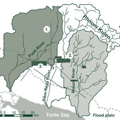
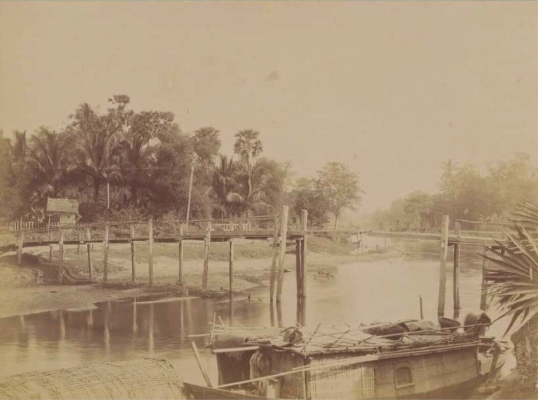
A rare photograph of the Siem Reap River taken by Louis Fournereau’s Mission in the 1880s, reproduced on glass plate by Alfred Molteni for screening at a 1887 conference by Fournereau for the Paris Société de géographie. Source: gallica.bnf.fr
A rare photograph of the Siem Reap River taken by Louis Fournereau’s Mission in the 1880s, reproduced on glass plate by Alfred Molteni for screening at a 1887 conference by Fournereau for the Paris Société de géographie. Source: gallica.bnf.fr
More about the River
At the turn of the (previous) century, French explorer Lunet de Lajonquiere had noted the importance of the rivers for Siem Reap and Angkor, but also the impact of Stung Siem Reap watershed on archaeological sites. In Inventaire descriptif des monuments du Cambodge (vol III, 1912), he wrote:
La province englobe ainsi le bassin de plusieurs rivières, dont les principales sont, en allant de l’E. à l’O.: le Stung Roluos, le Stung Siem Reap, le Stung Puok, le Stung Plang, et la presque totalité de la vallée du Stung Sreng. [p 7] [The province thus encompasses the basin of several rivers, the main of which are, going from the E. to the W.: Stung Roluos, Stung Siem Reap, Stung Puok, Stung Plang, and almost the entire Stung Sreng valley. [p 7]]
Further on, he remarked about Spean Thma (ស្ពានថ្ម, “Le pont de pierre,” “The Stone Bridge”), entry 491 in his Inventory [1]:
Il est situé à environ 700 mètres à l’est de la porte septentrionale de l’enceinte d’Angkor Thom. Il jalonne, sans doute, la route qui, par Beng Mealea et le Spean Ta Ong, gagnait Prah khan, droit vers l’Est, dans la province de Promtep. Il servait ici à passer le Stung Siemreap; mais la rivière, après avoir ensablé les arches très étroites, s’est rejetée vers l’Est et, creusant la rive de ce côté, contourne maintenant les débris du pont qui est, par suite, impraticable. De l’ouvrage d’art qui existait la autrefois, on né voit donc plus que quelques piles en limonite, les autres ayant été recouvertes par les apports de la rivière. Elles sont semblables à celles que nous avons vues dans les ouvrages similaires: leur épaisseur moyenne est de 1 m.80, et l’ouverture des arches mesure seulement un peu plus de 1 mètre. Quelques-uns des blocs de limonite employés à cette construction portent […] des traces d’ornementation, indiquant qu’ils ont été empruntés à des temples démolis. [The bridge is located approximately 700 meters east of the northern gate of the Angkor Thom enclosure. It undoubtedly marks out the road which, via Beng Mealea and the Spean Ta Ong, reached Prah Khan, straight towards the East, in the province of Promtep. It was used here to pass the Stung Siemreap; but the river, after having silted up the very narrow arches, has flowed towards east and, digging the bank on this side, now skirts the remains of the bridge which is, consequently, impassable. Of the engineering work that once existed there, we can only see a few limonite piles, the others having been covered by the river’s inflows. They are similar to those we have seen in similar works: their average thickness is 1.80 m, and the opening of the arches measures only a little over 1 meter. Some of the limonite blocks used in this construction […] bear traces of ornamentation, indicating that they were borrowed from demolished temples.
[1] The ruined bridge can be seen nowadays, right next to Prasat Takeo Nursery to the east.
[February 4 [1881] Returning, at four o’clock in the afternoon, at the entrance to the Angcor arroyo, we went up it as quickly as the fatigue of our crews allowed, and around seven o’clock we reached a small village; we anchor opposite to spend the night. February 5. The next morning, after eight hours of insomnia, I made a deal with the misroc to rent two junks into which we transhipped our luggage; then I bid farewell to the mandarin of Battambang, giving him a letter of thanks for Catatone. There are no carts in the maritime village where we docked; I therefore see myself forced to make the journey to Angcor on foot. Europeans from Saigon do it by boat during the high water season; the native junks take them at the mouth of the river and take them to the city of Siam-Rep, today’s Angcor. But in February the navigation was interrupted by drought, and I decided that we would leave on foot the next day. The afternoon is devoted to an unsuccessful attempt to climb Pnom-Crôm [Phnom Krom]; this hill is not 100 meters high above the plain, but the drowned forests make its approach inaccessible from the lake side; it can only be climbed from the north. This is the second time that I have gotten lost in the maze of these woods, led by native guides.
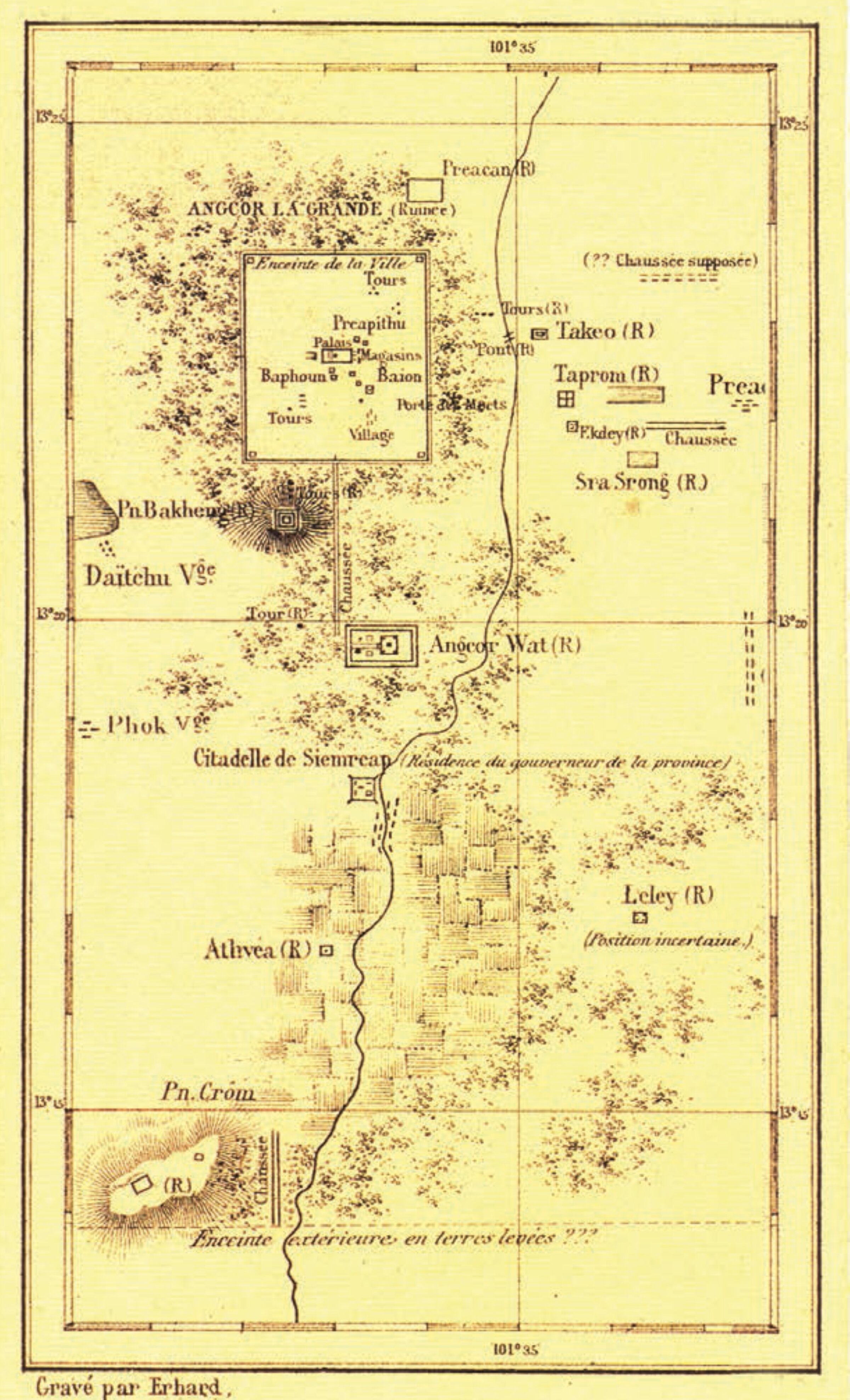
Map of Angkor Surroundings (1866 or 1871 according to Darryl Collins). Notice the straight course of the river through Siem Reap City.
Map of Angkor Surroundings (1866 or 1871 according to Darryl Collins). Notice the straight course of the river through Siem Reap City.
3. French writer Emile Vedel gave this description of Siem Reap in his Revue-des-deux-Mondes 1899 article:
Le jour décline quand nous arrivons a Siem-Reap. Egrenees sur les deux bords d’une rivière assez encaissée, les maisons sont en bois, comme perchées sur des poteaux; sous leur plancher viennent s’abriter les animaux domestiques, buffles, cochons, poules et chiens efflanques. Chaque habitation possède un petit jardin planté de cocotiers, de bananiers, de manguiers, d’arekiers, de borassus, et de graciles touffes de bambou. A travers les verdures sombres des arbres fruitiers, le soleil, pres de son coucher, nous envoie ses derniers rayons, qui flamboient comme des coulées d’or fondu. Les oiseaux se hâtent de rentrer des lacs, traversant le ciel en longs vols triangulaires. Presque personne sur le seuil des portes, tout le monde est à prendre le bain du soir dans la rivière. Nous la traversons à gué, faisant halte au fil de l’eau pour laisser les boeufs et les buffles se désaltérer et, de l’autre cote, nous allons nous arreter sur une sorte de place, au pied d’une grande case. [The day is fading when we reach Siem-Reap. Scattered on both banks of a fairly deep river, the houses are made of wood, as if perched on posts; under their floors come to shelter domestic animals, buffaloes, pigs, chickens and skinny dogs. Each dwelling has a small garden planted with coconut trees, banana trees, mango trees, arek trees, borassus, and slender tufts of bamboo. Through the dark greenery of the fruit trees, the sun, near its setting, sends us its last rays, which blaze like streams of molten gold. The birds hurry back from the lakes, crossing the sky in long triangular flights. Almost no one on the threshold of the doors, everyone is taking the evening bath in the river. We cross it by ford, stopping at the water’s edge to let the oxen and buffalo quench their thirst and, on the other side, we stop at a sort of square, at the foot of a large hut.] [p 600]
4. Jean Boulbet, who rediscovered the Thousand Linga site near Kbal Spean, focused on the upper part of the river in his study Le Kulen et sa région, calling Stung Siem Reap “le seul cours d’eau permanent de la région, une rivière à la fois sacrée et marquée d’un tabou” [the only permanent watercourse in the region, a river both sacred and marked with a taboo”]:
Comme ils excellaient à utiliser les données naturelles, les ingénieurs de l’empire khmèr ont certainement exploité la vocation de réservoir du plateau oriental en augmentant par leurs ouvrages la capacité de rétention de la Montagne du grand Indra. À la vue des bassins, des digues, des exutoires, des emplacements de vannes et des aménagements divers, il n’est pas interdit de penser que l’eau, ingénieusement conservée puis dirigée, s’écoulait à volonté suivant les besoins de la rivière de Siemréap, besoins qui devaient être, en saison sèche, disproportionnés à la surface et à la capacité du bassin d’alimentation. Ainsi la rivière, dont le débit est actuellement jugé insuffisant, a vraisemblablement été aménagée à partir de ses sources afin d’approvisionner constamment en eau le coeur de l’ancien empire khmèr et de rendre Jes hommes moins tributaires de l’alternance implacable des saisons.[…] Donc, les rois n’ont pas résidé au Mont et la première capitale fut aussi la dernière. Le seul souverain dont le séjour épisodique a marqué le phnom fut le “roi lépreux”. Alors que bien des faits essentiels, dont l’érection du premier Linga royal, n’ont pas laissé de traces dans les mémoires, tout ce qui concerne le séjour du roi lépreux est largement connu. ll y a une voie dite “voie royale” : c’est celle qu’a fait tailler le souverain malade pour se rendre de Boeng Méaléa au Mont pour y faire sa cure. De tous les sites attribués au roi lépreux (temple, clairière, halte … ), celui des Linga sculptés dans le lit de la rivière principale en amont de la cascade reste le plus fameux: c’est là que le souverain a subi son traitement médical et purificateur. De cet épisode, la rivière a pris et conservé un aspect inquiétant qui, joint à sa situation en amont des grands temples angkoriens, explique l’installation des hommes à l’écart de ses rives frappées d’interdit. [As they excelled at using natural terrain, the engineers of the Khmer empire certainly exploited the role of reservoir of the eastern plateau by increasing through their works the retention capacity of the Mountain of the great Indra. At the sight of the basins, the dikes, the outlets, the locations of the valves and the various installations, it is not impossible to think that the water, ingeniously preserved then directed, flowed at will according to the needs of the Siemréap river, needs which had to be, in the dry season, disproportionate to the surface area and capacity of the watershed. Thus the river, whose flow is currently considered insufficient, was probably developed from its sources in order to constantly supply the heart of the ancient Khmer empire with water and to make men less dependent on the relentless alternation of the seasons. .[…] Therefore, the kings did not reside at the Mount and the first capital was also the last. The only sovereign whose episodic stay marked the phnom was the “leper king”. While many essential facts, including the erection of the first royal Linga, have not left a trace in memories, everything concerning the stay of the leper king is widely known. There is a road called the “royal road”: it is the one that the sick sovereign had cut to go from Boeng Méaléa to the Mount to take his cure. Of all the sites attributed to the leper king (temple, clearing, rest stop, etc.), that of the Linga carved in the bed of the main river upstream of the waterfall remains the most famous: it is there that the sovereign underwent his medical treatments and purification. From this episode, the river took on and has retained a worrying aspect which, combined with its location upstream of the great Angkorian temples, explains the settlement of men away from its forbidden banks.]
Sur le Plateau oriental dit “Echine du Mont”, haut bassin de la Rivière de Siemréap (khnati bhnarp, kpal sdin siemrap; khnong phnom, kbal stoeng siemréap): abrité et en pente douce, le revers intérieur des crêtes forme une cuvette légèrement creusée par les gouttières des cours d’eau qui confluent pour former la Rivière de Siemréap. La première déclivité, en partant de la crête de bordure, peut encore présenter des sols à texture grossière et des arènes sableuses, voire des affleurements rocheux. Mais, après une marche plus ou moins marquée, la dernière et longue déclivité vers les gouttières centrales et, surtout, vers la Rivière de Siemréap est faite de sols sablo-argileux profonds. Issus de la décomposition des grès, mais recouverts d’un horizon humifière sombre et à texture fine, ces terrains, bien drainés et alimentés en saison sèche par une nappe phréatique proche (tï kanden kpal dik, dei kândeng kbal toek ou ”terre argilo-limoneuse des têtes d’eau”), sont ceux sur lesquels croît la plus belle futaie et qui ont particulièrement attiré les hommes. Historiquement, les plus importantes des dépressions du plateau oriental de l’Echine du Mont ont été élargies et creusées jusqu’à l’horizon argileux compact. Par places, des blocs de grès surgissent, isolément ou en chaos, mais leurs bases restent noyées dans les sols forestiers d’où ils émergent sans former de socles ni de dalles. [On the eastern Plateau known as “the Hill Spine”, the high basin of the Siemréap River (khnati bhnarp, kpal sdin siemrap; khnong phnom, kbal stoeng siemréap): sheltered and gently sloping, the inner side of the ridges forms a basin slightly hollowed by the gutters of the watercourses which confluence to form the Siemréap River. The first slope, starting from the border crest, can still present coarse-textured soils and sandy arenas, or even rocky outcrops. But, after a more or less marked walk, the last and long slope towards the central gutters and, above all, towards the Siemréap River is made of deep sandy-clayed soils. Resulting from the decomposition of sandstones, but covered with a dark, fine-textured humus, these lands, well drained and fed in the dry season by a nearby water table (tï kanden kpal dik, dei kândeng kbal toek or ”clay-silt land of water heads”), are those on which the most beautiful high forest grows and which have particularly attracted men. Historically, the most important depressions of the eastern plateau of the Hill Spine were widened and dug until on the compact clay horizon, in places, blocks of sandstone arise, singly or in chaos, but their bases remain embedded in the forest soils from which they emerge without forming bases or slabs.]
“Pont roulant” [bridge crane] over Siem Reap River, 1887 (source gallica.bnf.fr)
“Pont roulant” [bridge crane] over Siem Reap River, 1887 (source gallica.bnf.fr)
3. Launched in 2024, the NGO Sochivita (“Harmonious Life”) aims at revitalizing the ecosystem corridor of the Siem Reap River, “a vital ecological corridor that connects Angkor to the Tonle Sap and faces significant pressure due to Krong Siem Reap’s rapid urbanization. This urban expansion threatens the river’s interconnected ecosystems, necessitating a masterplan for ecological restoration alongside sustainable coexistence with human activity. As the project reconnects the two habitats, it also revitalizes city life and the economy.” With innovative solutions such as floating gardens and interconnected nurseries, can we dream of a day when we’ll be able to leisurely boat from the Lake to Angkor Wat?
For more information about this project piloted by AION Architecture and Forum 24 Architecture, email hidden; JavaScript is required.
Mathematician and civil engineer Terry Lustig is an independent scholar, affiliated to the Greater Angkor Project and the University of Sydney (Department of Archeology).
Matti Kummu
Matti Kummu is Associate professor at the Department of Built Environment, Aalto University, Espoo, Finland, specializing in Hydrology, Geoinformatics (GIS), Climatology, Irrigation and Water Management, local scale challenges and opportunities on water-energy-food nexus, particularly in Southeast Asian context.
He co-authored various studies on Tonle Sap Lake, in line with the aim of reflecting on the ever-growing pressure on water and land resources, and quantifying the potential of different measures, such as diet change, food loss reduction, emerging non-meat protein sources, and yield gap closure, to sustainably increase the food availability globally.
sk लिङ्ग linga, 'penis', 'grammatical gender', 'mark', 'sign', 'a type of ancient temple' | kh លិង្គ lengk 'gender', 'feature', 'attribute', 'male genitalia'
The liṅga is a semi-iconic (between the iconic and the aniconic) image of Śiva. A cylindrical shaft with phallic connotations, it is often associated to the yoni, symbolic representation of the female genitalia, the matrix of anything [1].
The linga symbol is ever-present in Southeast Asian architecture and religious representations. It has absorbed ancient local cults of uncut stones. Associated with fertility rituals in Cambodia, it became the physical embodiment of the kamraten jagat raja or devaraja, the vector of the divine essence attached to kingship.
[1] In Tibetan Vajrayana (tantric Buddhism), 'liṅga' refers to the “upper genitals” [penis or clitoris].