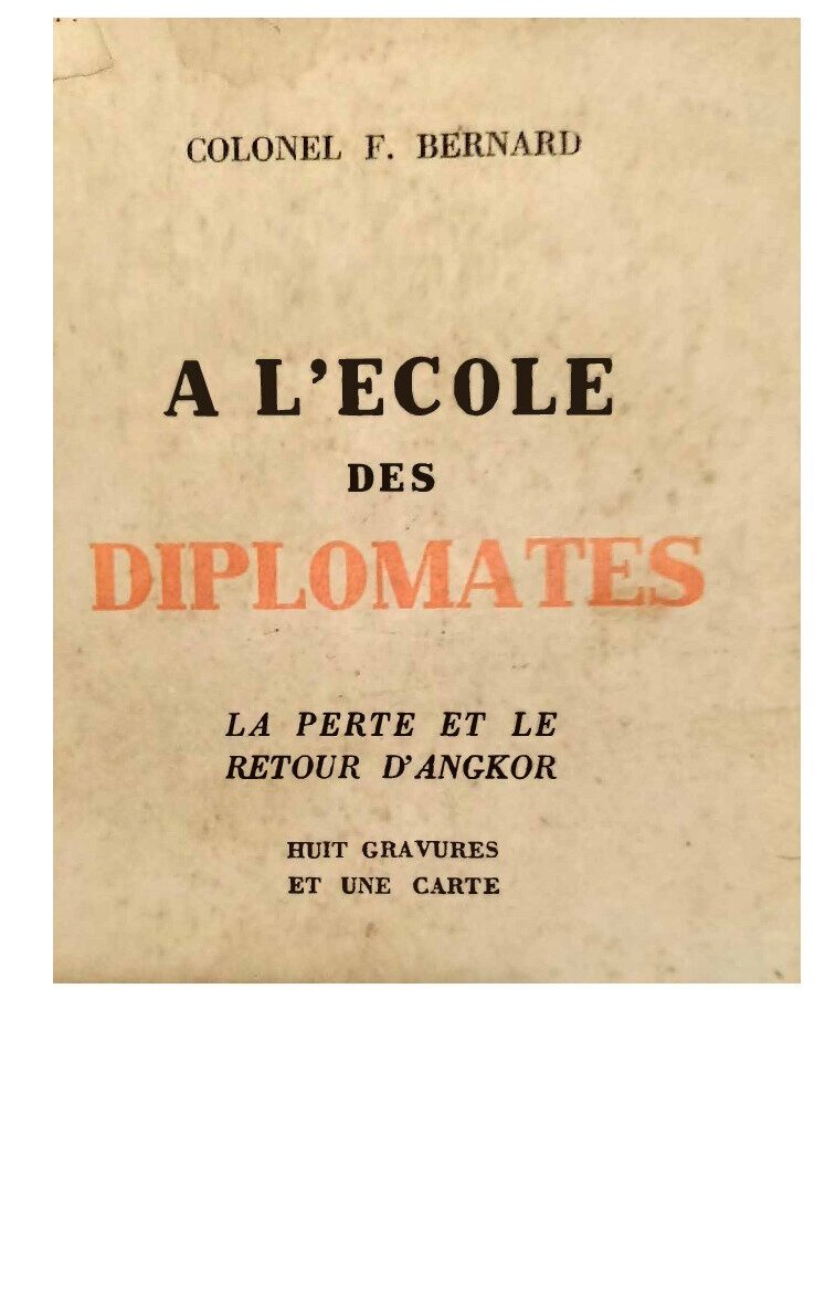
Aleading member of the French delegation to the Siamese-French negotiations working towards the restitution of Cambodian annexed provinces, the author was not a diplomat by trade but a staunch promoter of this historic improvement in the geopolitical standing of the Khmer Kingdom, culminating in the 23 March 1907 Treaty.
The same year the present book was published, George Coedès, who was in the best terms both with Siamese officials and the Cambodian royals as he kept a rigorously neutral stand as a renowned historian, wrote a remarkably positive review in the Bulletin de l’Ecole française d’Extrême-Orient (BEFEO t 33, 1933, p. 993), noting that “ce petit volume, certainement le plus vivant de tous ceux qui ont été écrits depuis 1893 sur la «question du Siam», tend à démontrer que si la perte des provinces de Siemrâp, Sisóphon et Battamban fut l’oeuvre d’une diplomatie incapable, leur retour au Cambodge en 1907 est due aux militaires et aux coloniaux qui composaient la Commission de délimitation de la frontière franco-siamoise, présidée par l’auteur de 1904 à 1907. C’est un ouvrage de polémique, de style incisif, dans lequel les événements vécus par l’auteur sont présentés avec un rare relief.” [“this small volume, certainly the most lively of all those written since 1893 on the “Siamese question,” tends to demonstrate that if the loss of the provinces of Siemreap, Sisophon, and Battamban was the work of an inefficient diplomacy, their return to Cambodia in 1907 was due to the military and colonialists who composed the Franco-Siamese Border Demarcation Commission, chaired by the author from 1904 to 1907. It is a polemical work, incisive in style, in which the events experienced by the author are presented with rare clarity.”
And in effect, the author started his account with a clear indictment of the international policy of the first three decades of the French Third Republic, namely the “Legitimist” (pro-French royal restoration) and “moderate Republican” factions:
Les querelles qui dès notre installation en Indochine s’étaient élevées entre nous et nos voisins auraient pu en effet être réglées dès les premiers jours. Elles se sont au contraire prolongées pendant plus de 40 ans. Les conventions successives que nous avons conclues n’ont été que des trêves, rompues, dès leur conclusion par des incidents qu’il eut été facile de prévoir et d’éviter. Le problème qui se posait était simple. Il eut suffi de le connaître exactement pour le résoudre, et cependant toutes les tentatives d’accord n’ont eu, pendant longtemps, d’ autres résultats que de maintenir ou de créer des situations équivoques et de prolonger ainsi des conflits nouveaux. Losrqu’on cherche a expliquer l’attitude parfois singulieres de nos diplomates et les deboires qu’ils ont eprouves, on les ramene a trois causes essentielles:
L’incomprehension totale de la situation reciproque des deux parties;
L’ignorance des interets positifs qu’il s’agissait de defendre;
L’influence de théories generales inapplicables et de systèmes depuis longtemps perimes.
[The squabbles that arose between us and our neighbors from the moment we settled in Indochina could indeed have been settled in the very first days. Instead, they dragged on for over 40 years. The successive agreements we concluded were nothing more than truces, broken immediately upon their conclusion by incidents that could have been easily foreseen and avoided. The problem at hand was simple. It would have been enough to understand it precisely to resolve it, and yet all attempts at agreement had, for a long time, no other result than to maintain or create ambiguous situations and thus prolong new conflicts. When we seek to explain the sometimes unusual attitude of our diplomats and the setbacks they experienced, they are reduced to three essential causes:
A complete misunderstanding of the mutual situation of the two parties;
Ignorance of the positive interests that needed to be defended;
The influence of inapplicable general theories and long-outdated systems.[p 7 – 8]
After a brief summary of the de Montigny mission — a true case study in the inane diplomacy of Napoleon III’s Second Empire — , the author started to explicit why he chose for subheader “La perte et le retour d’Angkor” [The Loss and Return of Angkor]:
Continuer à dépecer le vieux royaume [le Cambodge], disputer aux Siamois ses dépouilles, s’acharner à faire disparaître jusqu’aux derniers vestiges d’une nation jadis puissante, une telle oeuvre eut été sans gloire et sans profit. Il n’y avait qu’une solution digne et rationnelle: faire reconnaître l’intégrité du Cambodge, prendre le royaume sous notre protection, défendre ses droits. Ce n’était pas là une politique de dupes, car nous acquérions, sans courir les risques d’une conquête, un marché dont nous allions profiter seuls. [p 41]
During these negotiations, the French party, representing de facto the Cambodian side, was mostly dealing with Prince Devawongse Varopakarn กรมพระยาเทวะวงศ์วโรปการ (27 November 1858 – 28 June 1923), brother of King Chulalongkorn (Rama V, 1868 – 1910) and Minister of Foreign Affairs, but was aware of the influence of Prince Damrong Rajanubabh who, as Minister of Interior in charge of the definition of territorial entities for the Kingdom, and as a budding archaeologist, firmly believed in the imperative need for what Siam never had before: the “geo-body” of a nation that was still in the making, a term coined by — precisely — Thai historian Thongchai Winichakul [see below], and a concept akin to the “mental map” of a transnational identity pursued by Ukrainian geographer Stepan Rudnitskyi (1877−1937).
While detailing the fine (geographical) points of the 1907 Treaty, Colonel Bernard often alluded to the reservations expressed by Prince Damrong — who had launched the first school of Siamese cartographers and surveyors in 1885 -, and to the difficulties encountered in mapping two kingdoms historically founded not on the allegiance of group of people more than on any territorial control. Here are some examples:
1‑The “Great Lake Basin”, a geographic and ethnic entity?
Les provinces de Battambang, Siem-Réap et Sisophon né forment pas la totalité du Bassin du Grand Lac. Il y a encore : 1) La province de Panomsok, située au nord de Battarnbang, et qui fait partie du Monthon-Burapah ; 2) Le territoire de Tchonkan situé au nord de Sièm Reap, et qui dépend d’Oubon; 3) Le district de Vattana, qui dépend de Pachim ; 4) Les districts de Ba Phra et Ban Sop Sai, au nord de Païlin, qui dépendent de Chantaboun. [The provinces of Battambang, Siem Reap, and Sisophon do not make for the entire Great Lake Basin. There are also: 1) Panomsok Province, located north of Battambang and part of Monthon-Burapah; 2) Chonkan territory, located north of Siem Reap and dependent on Oubon; 3) Vattana District, dependent on Pachim; 4) Ba Phra and Ban Sop Sai districts, north of Pailin, dependent on Chantaboun. [p 232 – 3]
One point is certainly the stuff of further studies regarding the remarkable status of the Battambang elites:
Il y avait une question qui préoccupait, d’une façon particulière le prince Damrong et le Roi. II s’agissait de savoir quelle situation serait faite au Phya Kathathorn après la rétrocession de Battambang. Le Phya Kathathorn (gouverneur de Battambang) est, en effet, un ami personnel du prince Damrong et à maintes reprises depuis quelques années, le gouvernement siamois lui a donné l’assurance qu’il né l’abandonnerait pas. Il s’agissait donc de maintenir à ce personnage une situation matérielle et morale telle, qu’il né put se plaindre d’avoir été sacrifié. J’ai donné, à ce sujet, toutes les assurances qui m’ont paru nécessaires et, bien que je n’ai pu sur ce point provoquer vos instructions, je suis certain que je né me suis pas engagé au delà de vos propres dispositions. [One question particularly worried Prince Damrong and the King — what situation would be in place for Phya Kathathorn after the return of Battambang [to Cambodia]. Phya Kathathorn (Governor of Battambang) is, in fact, a personal friend of Prince Damrong, and on numerous occasions over the past few years, the Siamese government has assured him that it would not abandon him. It was therefore a matter of maintaining this public figure’s material and moral standing such that he could not complain of having been sacrificed. I have given all the assurances I deemed necessary on this subject, and although I was unable to obtain your instructions on this point, I am certain that I have not committed myself beyond your own wishes.[p 236]
2‑The western sea façade: possibly Cambodian or too close to Bangkok?
The choices made by the author in 1907 have nowadays unforeseen consequences, as the maritime international boundary is firmly affixed to the border marker set at the southern tip of what has come to be called “The Narrowest Part of Thailand”, east of Koh Kut island: a staight line springing like an arrow westwards, a possible source of bilateral rivalry upon what might be found underwater (the mainland area was rich in gold and other minerals, and rumors of offshore black gold deposits abound. [Ko Kut or Koh Kood, th เกาะกูด kh កោះកូដ, under Thailand’s jurisdiction, the fourth largest island in Thailand.]
In this particular instance, the author and president of the French negotiating delegation was inclined to stick to what he saw and heard on the field, and to opt for some sort “ethnic reciprocity”: this part to the Siamese, that one to the Cambodians. He took the opportunity to scorn the French diplomats involved in the 1904 settlement:
“Nos négociateurs avaient [alors] exigé la cession du territoire de Kratt. Ils avaient affirmé que nous trouverions là un port de mer incomparable. Nous fumes étonnés de constater que ce port de mer était situé au milieu des terres, ce qui né laissait pas de présenter quelques difficultés pour la navigation. Une autre surprise nous y attendait. Le pays était cambodgien, le traité l’affirmait, les diplomates l’avaient juré, et l’on s’était hâté d’y installer un administrateur du Cambodge, des magistrats et des interprètes cambodgiens qui, malgré des efforts louables, né pouvaient se faire entendre des indigènes. Il se trouva d’autre part, que les Siamois qui m’accompagnaient comprenaient fort bien la langue de nos nouveaux sujets et je saisis aussitôt le Gouvernement de ce fait extraordinaire, à savoir que les Cambodgiens de Kratt parlaient siamois. [p 175]
In the spring and summer 1906, the terms of the treaty were still submitted to a tit-for-tat bargaining vividly recalled in these pages:
Nous né pouvions avoir la prétention d’obtenir du Gouvernement siamois, sans compensation, de nouveaux sacrifices territoriaux et nous né pouvions offrir en échange que le territoie de Bothène du côté de Luang Prabang, au nord de Dan-Sai. J’ai pensé que, du côté de Kratt, il fallait conserver au moins la province de Koh Kong qui, au point de vue géographique aussi bien qu’au point de vue ethnographique, se rattache intimement à la province cambodgienne de Thépong, tandis que Kratt est isolée de Pursat et de Battambang par la muraille des monts Krevanh. […] Le 14 [mars] au soir, j’ai eu avec M. Strobel une première discussion avec Phya Sri, sous-secrétaire d’Etat du Ministère de l’Intérieur et le Général Mom Chatidej Udom, Président de la Commission siamoise de délimitation. La discussion s’est poursuivie pendant quelques temps sans faire le moindre progrès et, finalement, j’ai proposé à Phya Sri de laisser au Gouvernement siamois la totalité de l’ancienne province de Kratt jusques et non compris Koh-Kong, de lui abandonner les îles situées au sud du cap Memling et de lui céder encore le territoire de Bothène s’il voulait, de son côté, accepter comme froritiere les limites mêmes du bassin du Grand Lac. Ces propositions ont paru trop graves pour que l’on puisse immediatement les discuter et nous avons decidé d’une autre réunion le lendernain matin. Elles ont été, avant cette reunion, communiquées par Phya Sri au prince Damrong et elles ont provoqué une émotion à laquelle j’etais loin de m’attendre. Au lieu de les considerer simplement comme ayant le caractere d’un marché, que l’on pourrait également repousser ou rediscuter, on a cru y voir de nouvelles et irreductibles pretentions. On s est imaginé que nous n’avions d’autre but que de nous établir à proximité immédiate de Chantaboum, d’une part, de la rivière de Pétriou et de Bangkok, d’autre part. Il règne au Siam, à notre égard, une telle méfiance, on redoute à tel point une action militaire éventuelle que le prince Damrong et Phya Sri ont déclaré qu’ils préféraient né pas traiter, plutôt que d’accepter un tracé de frontiere dont l’adoption pourrait mettre des troupes françaises à quelques journées de marche de Bangkok. [We could not possibly pretend to obtain from the Siamese Government, new territorial sacrifices without compensation, and we could only offer in exchange the territory of Bothene on the side of Luang Prabang, north of Dan-Sai. I thought that, on the Kratt side, it was necessary to preserve at least the province of Koh Kong which, from a geographical as well as an ethnographic point of view, is closely linked to the Cambodian province of Thépong, while Kratt is isolated from Pursat and Battambang by the wall of the Krevanh mountains. […] On the evening of 14 [March], I had an initial discussion with Mr. Strobel with Phya Sri, Undersecretary of State of the Ministry of the Interior and General Mom Chatidej Udom, President of the Siamese Delimitation Commission. The discussion continued for some time without making the slightest progress and, finally, I proposed to Phya Sri to leave to the Siamese Government the whole of the former province of Kratt up to and not including Koh Kong, to abandon to it the islands situated to the south of Cape Memling and to cede to it also the territory of Bothene if it would, for its part, accept as its border the very limits of the basin of the Great Lake. These proposals seemed too serious to be discussed immediately and we decided to have another meeting the following morning. Before this meeting, they were communicated by Phya Sri to Prince Damrong and they provoked an emotion which I was far from expecting. Instead of considering them simply as having the character of a bargain, which could equally be rejected or rediscussed, it was believed there were new and irreducible pretensions. It was imagined that our only goal was to establish ourselves in the immediate vicinity of Chantaboum, on the one hand, and of the Petriou River and Bangkok, on the other. There is such distrust in Siam towards us, and such fear of possible military action, that Prince Damrong and Phya Sri have declared that they would prefer not to negotiate rather than accept a frontier whose adoption could put French troops within a few days’ march of Bangkok.][p 233 – 4]
3- Avoiding to repeat the 1867 “fool’s bargain”
Earlier, the author had recalled
Les Siamois savaient fort bien que leurs titres juridiques sur un certain nombre de provinces étaient nuls: « les plénipotentiaires siamois auraient voulu qu’à la suite des deux provinces sus-désignées (Battambang et Angkor) on ajoutât celles de Manophraï (Meluprey), Salampho (Tonle Repou), Xieng Treng (Stung Treng), Chantaburi (Chantaboun), Kratt, Pachim et Koh Kong. Cet amendement a été repoussé et, par le fait, les droits du Cambodge demeurent réservés pour toutes provinces autres que Battambang et Angkor. (Lettre de l’amiral Rigault de Genouilly, ministre de la Marine, à l’amiral de La Grandière: 12 juillet 1867). [The Siamese knew very well that their legal titles to a certain number of provinces were null and void: “the Siamese plenipotentiaries would have liked to add, after the two above-mentioned provinces (Battambang and Angkor), those of Manophraï (Meluprey), Salampho (Tonle Repou), Xieng Treng (Stung Treng), Chantaburi (Chantaboun), Kratt, Pachim and Koh Kong. This amendment was rejected and, as a result, the rights of Cambodia remain reserved for all provinces other than Battambang and Angkor. (Letter from Admiral Rigault de Genouilly, Minister of the Navy, to Admiral de La Grandière: July 12, 1867)[p 67]
Settling the matter of extraterritoriality, unsettling the territorial modus vivendi
Little attention is paid nowadays to the fact that France, as a colonial power, conceded an important recognition of Siam’s sovereignty with the 23 March Treaty ending French extraterritoriality over its Asian subjects in Siam. As Etienne Aymonier had noted at that time (Le Cambodge: Les provinces siamoises, p 8) “about eight millions souls live in the Kingdom of Siam, two-third of them in Menam Valley. Overall, there are three millions of Siamese, two millions of Chinese, one million of Malay people, one million of Lao, eight hundred thousands Cambodians, one hundred thousand Peguans, and one hundred thousand “aborigines”: Kariengs, Lawas, Xong, Kouys.” France was thus relinquishing his control over two large minorities, Laotian and Cambodian.
On the territorial boundaries themselves, the negotiators gave general recommendations only:
1) Le Siam nous laisserait la province de Koh Kong, celle de de Panomsok et le district de Tchon-Katt; 2) Nous laisserions au Siam le territoire de Kratt jusqu’en un point de la côte situé en face de l’ile de Koh-Kut et toutes les îles situées au sud du cap Memling jusques et y compris Koh Kut. 3) La delimitation laisserait au Siam la possession d’une route directe allant d’Aranh à Korat par la passé de Chong-ta-Koh. 4) A partir des Dangrek, la frontière suivra, dans la direction de l’est, la ligne de partage des eaux entre la Sémoune, d’une part, le bassin du Grand Lac et celui du Mékong, d’autre part, et viendra aboutir au Mékong en aval de Pakmoun, conformément au tracé que la Commission de délimitation vient de déterminer. [1) Siam would leave us the province of Koh Kong, that of Panomsok and the district of Tchon-Katt; 2) We would leave to Siam the territory of Kratt up to a point on the coast situated opposite the island of Koh-Kut and all the islands situated to the south of Cape Memling up to and including Koh Kut. 3) The delimitation would leave to Siam the possession of a direct route going from Aranh to Korat by the Chong-ta-Koh Pass. 4) From the Dangrek, the frontier will follow, in an easterly direction, the watershed between the Semoun, on the one hand, and the basin of the Great Lake and that of the Mekong, on the other hand, and will end at the Mekong below Pakmoun, in accordance with the line which the Delimitation Commission has just determined.] [p234‑5]
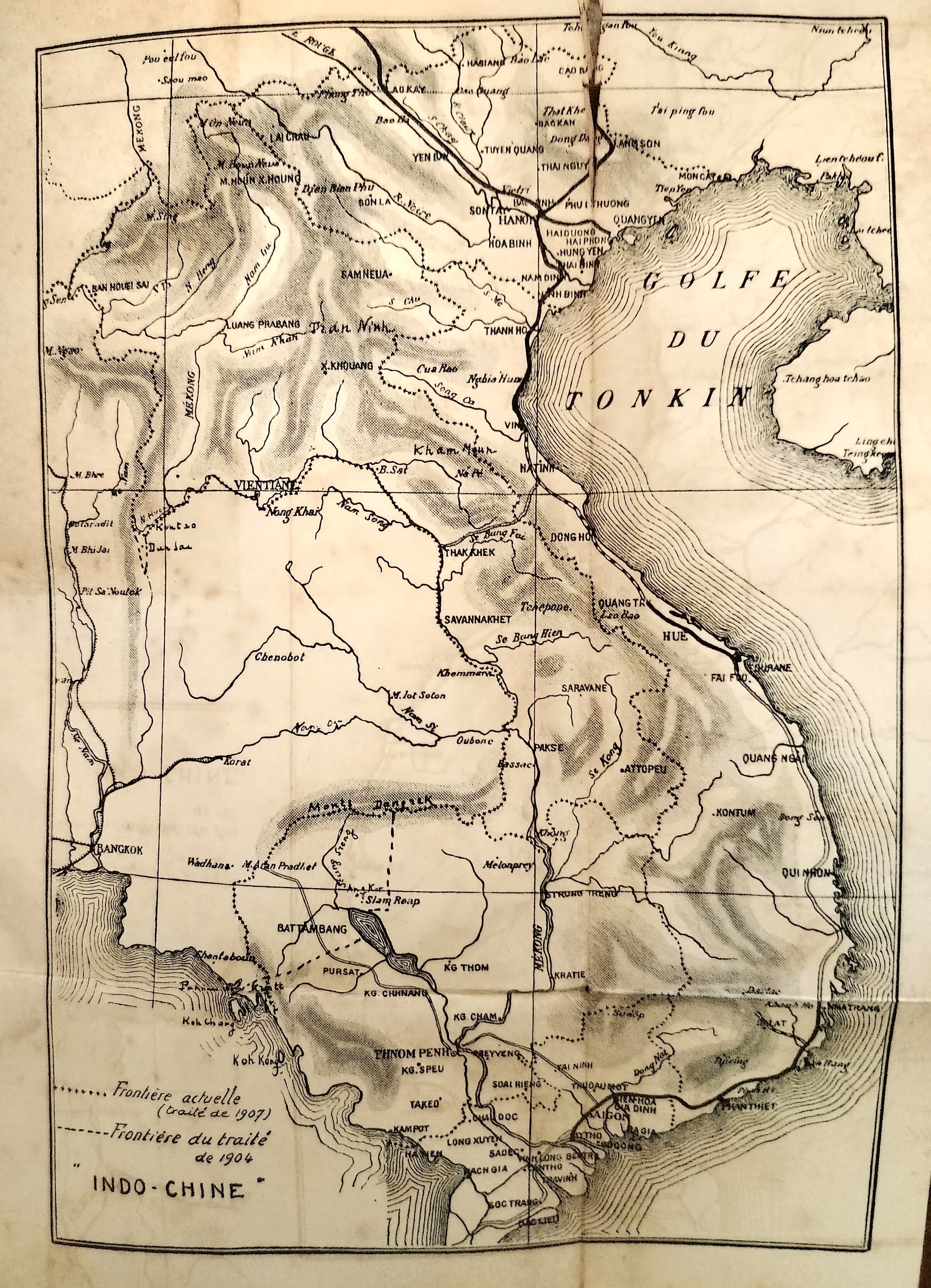
Future conundrums were brewing and ready to break out in the very apparatus of maps produced around the 23 March Treaty. Neither side was fully equipped to deal with the challenge of building from scratch the cartography of modern States-nations when the latter were still only emerging. On the French side, earlier maps had been drawn by military explorers (Francis Garnier, Doudart de Lagrée) or archaeologists-historians (Etienne Aymonier, Lunet de Lajonquière); as for Auguste Pavie, explorer and diplomat, he had — deliberately, or feeling he was lacking sufficient information — avoided to draw too precisely any boundary line in the peninsula. They were more topographical than anything. On the Siamese side, mapping the territory would have implied a spatial representation of the royal influence: “Siam and its dependents”, but how willingly and how knowingly dependent?
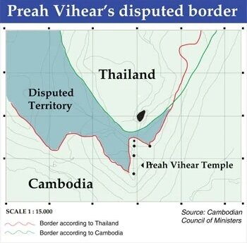
To follow the line of a mountain range in order to establish boundary is always tricky: mountain people do not easily embrace the idea of “this and that sides of the hill”, especially when mountain tops attract sacred sites and rituals. The case of Preah Vihear temple, which flared up in 1932, and again in the 1960s, 1970s, 2010s, keeps illustrating this challenge to modern, national boundary makers. In its Rejoinder to the International Court of Justice on 2 Feb 1962 (Doc n 9257), the Royal Government of Thailand would attempt to use the fact that the “rough sketch” (Annex II to the 1907 Treaty) had been declared lost, then found again, in order to undermine a “too rough” mapping…
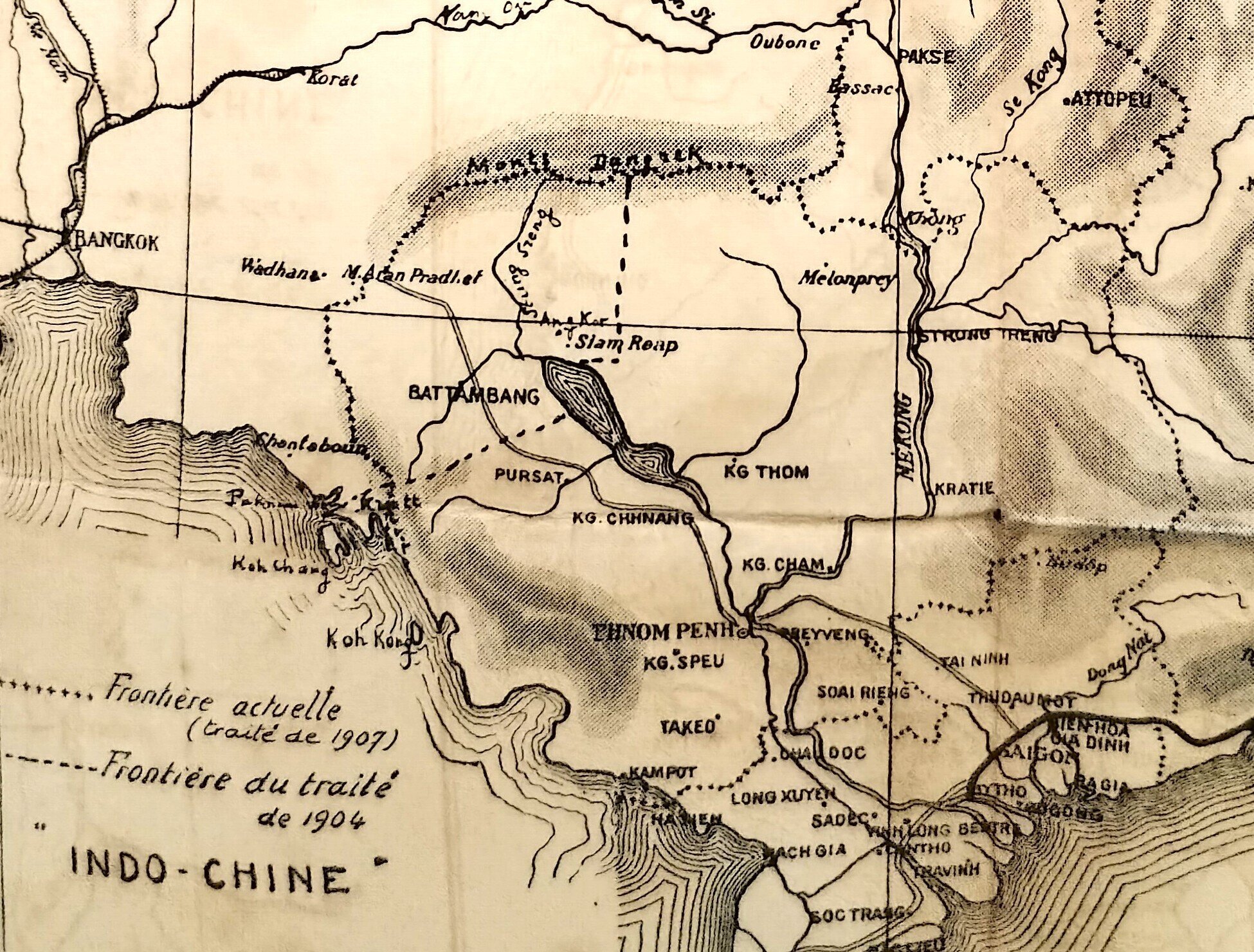
Colonel Bernard’s map attached to the book; enlarged part of the coastal area showing the variation between the 1904 and 1907 lines.
Colonel Bernard’s map attached to the book; enlarged part of the coastal area showing the variation between the 1904 and 1907 lines.
Colonel Bernard’s map attached to the book; enlarged part of the coastal area showing the variation between the 1904 and 1907 lines.
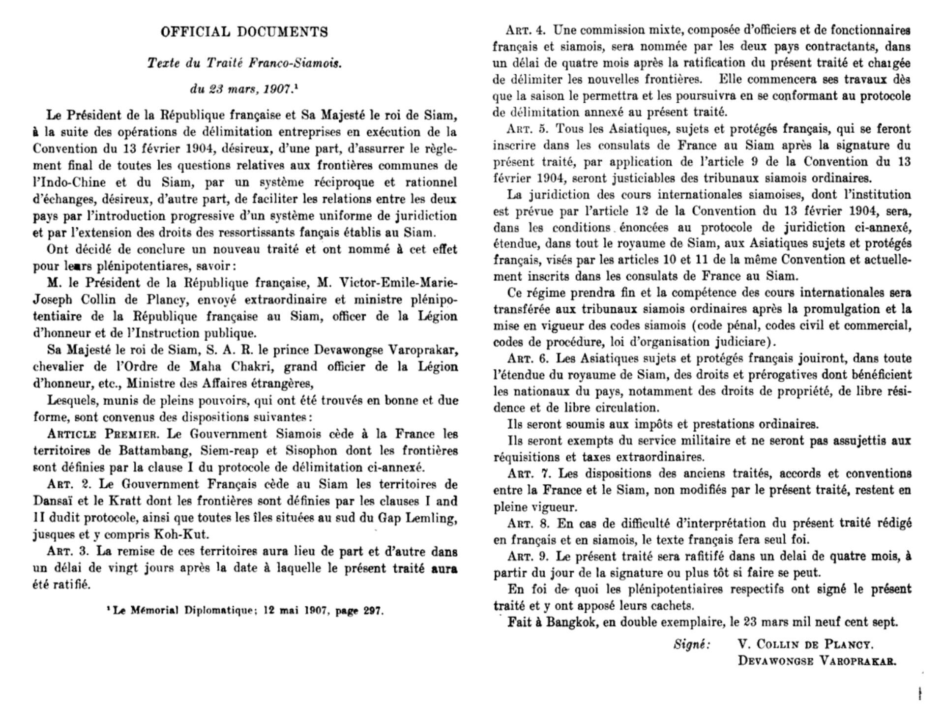
The French version of the Treaty published by the Comité de l’Asie française and quoted in Le Mémorial Diplomatique, 12 mai 1907, Paris, p. 297.
The French version of the Treaty published by the Comité de l’Asie française and quoted in Le Mémorial Diplomatique, 12 mai 1907, Paris, p. 297.
James F. McCarthy and the eluding “survey of Siam”
Colonel Bernard was of course aware of the first comprehensive map of Siam published in Bangkok in 1887 (not in 1886 as he mistakenly stated in his book), and he mentioned it, complete with another swipe to the French diplomat:
La carte que le gouvernement siamois avait fait établir par Mac Carthy [“General Surveyor” (chef du service géodesique) du Siam, ce qu’on traduisait au Quai d’Orsay, grace a une connaissance parfaite de la langue anglaise, par “surveillant-general”) indiquait hardiment la limite des territoires que le Siam s’attribuait. Cette ligne suivait la crete de partage des eaux entre la mer de Chine et le Mekong jusqu’à hauteur de Vinh, puis, à partir de ce point, elle descendait sur le versant annamite, coupait le Song Ca à Cua Rao, le Song Ma à une centaine de kilometres de Thanh Hoa, aboutissait à la Rivière Noire un peu en amont de Cho Bo, en remontait le cours, englobait sur la rive gauche le district de Muong Cheng, nous enlevant ainsi tous les districts montagneux et boisés du nord de l’Annam et le quart du Tonkin jusqu’à 50 kilometres du Fleuve Rouge. Ces prétentions insolentes provoquèrent des protestations énergiques parmi les coloniaux. [The map that the Siamese government had drawn up by Mac Carthy [“General Surveyor” (head of the geodetic service) of Siam, which was translated at the Quai d’Orsay, thanks to a perfect knowledge of the English language, as “supervisor-general”) brazenly indicated the limit of the territories that Siam was claiming for itself. This line followed the watershed between the China Sea and the Mekong up to the height of Vinh, then, from this point, it descended on the Annamite slope, cut the Song Ca at Cua Rao, the Song Ma about a hundred kilometers from Thanh Hoa, ended at the Black River a little upstream of Cho Bo, went up its course, included on the left bank the district of Muong Cheng, thus removing from us all the mountainous and wooded districts of the north of Annam and a quarter of Tonkin up to 50 kilometers from the Red River. These insolent claims provoked energetic protests among the colonials.[p 97 – 8]
James Fitzroy McCarthy (1853 — 23 September 1919) was an Irish surveyor and cartographer entrusted by the King of Siam in completing the first official map of the kingdom “and its dependencies.” He was a member of the Survey of India when he was sent to Burma in 1873, and from there moved to Siam. An indefatigable explorer, he was tempted to find new dimensions in the scientific yet quite arid art of triangulation. After he became the first Director-General of Siam’s Royal Survey Department, in 1885, he tried a more historic and even ethnographic approach to the maze of different Siamese and Cambodian toponyms in the border areas — even if the map of his we publish here didn’t mention any major Khmer temple or monastery apart from Nakawn Wat (Angkor Wat, labeled “Ruins of Angkor”) . In his essential essay (more on that below), Thongchai Winichakul recalled that
At one point McCarthy requested authority from the king to move forward to areas where [Siamese] troops had yet to go but had been delayed by administrative work in the conquered towns. Enthusiastically, McCarthy suggested that he could ask local people about the histories of these towns to decide where he should locate the boundary and map it. “We, then, can know the land where we live,” he wrote to the king. The king, perhaps not less enthusiastic, praised him but warned: “It seems that [McCarthy] will decide the boundaries by himself.” Consciously or not, that is precisely what McCarthy was doing. He realized the power of mapping. [op. cit. below, p 123]
There was an intrinsic flaw in the General Surveyor surveyor’s reasoning:
In the indigenous Southeast Asian tradition, a subject was bound first and foremost to his lord rather than to a state. People who lived in one area might not necessarily belong to the ruler of that area, although they might still have to pay tax or rent to the lord of that land. As the surveyor James McCarthy noted with puzzlement, it was a peculiar custom in which the power over individuals and land was separated. As a modern Western man, he did not realize that this custom was quite common in the region and throughout Asia.”[op. cit. below, p. 160] [ADB note: this specificity of Southeast Asian space representation has been explorer by researcher Grégory Mikaelian in his essay on the history of Cambodian cartography.]
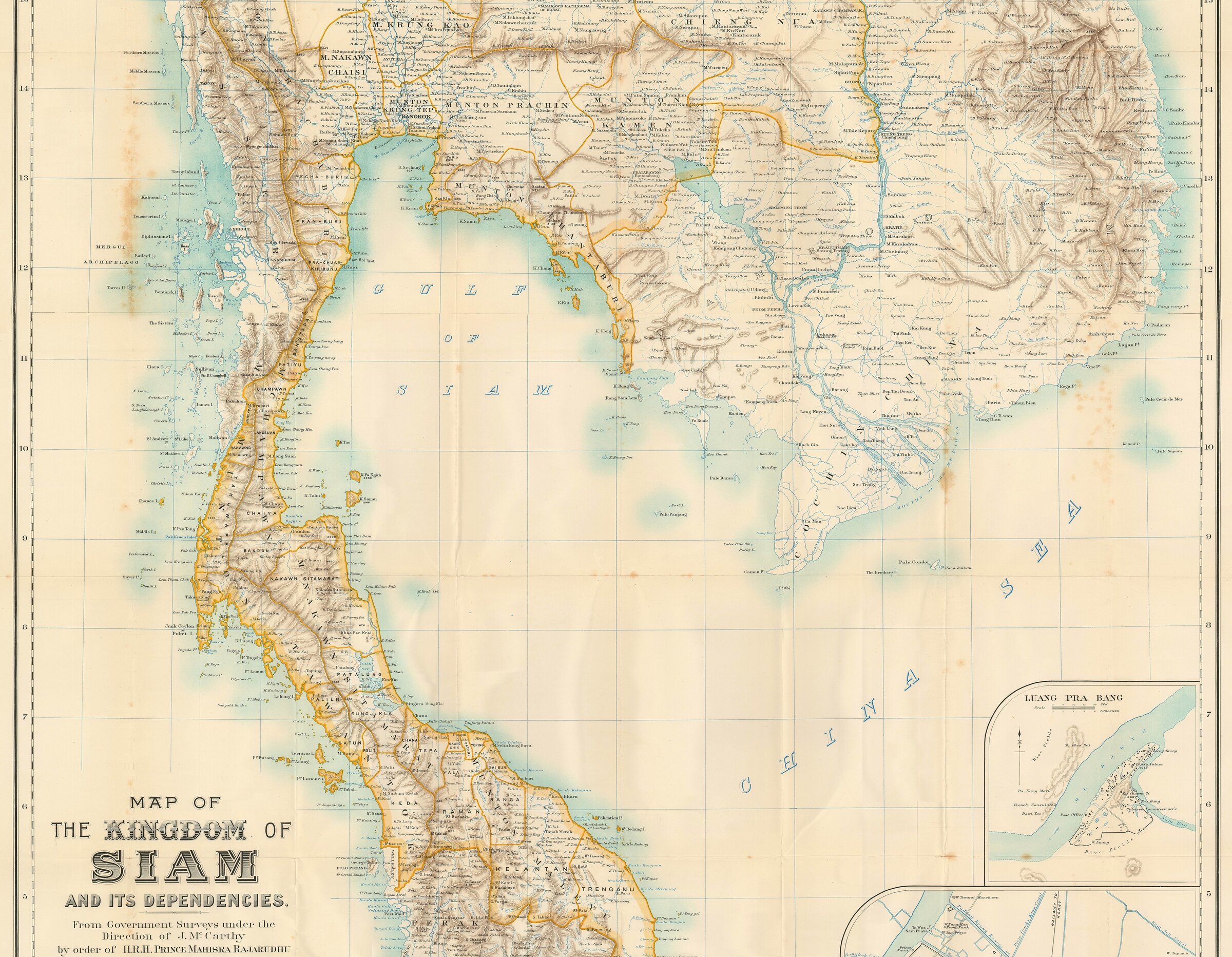
Surveyor General of Siam, 1900 | via Geographicus Rare Antique Maps (www.geographicus.com)
Map of the Kingdom of Siam and its Dependencies, from Government Survey under the Direction of J. Mc Carthy by order of HRH Prince Mahisra Rajarudhu, 1900. This is an expanded version of the first map published in 1887 by the same Surveyor General. ADB note: detail focusing on the Cambodian-Siamese borders, as the original map covered the whole Kingdom up to Burma in the north.
In his own relation of his long years spent in Siam [James F. McCarthy, Suveying and Exploring in Siam, London, John Murray, 215 p.], the cartographer mentioned Cambodia only twice, in the first instance as Cambodian women representing their “subjugated nationality” at a royal Siamese ceremony, the second referring to a legend related to the Kingdom of Sukhotai, one implying that “powerful states” of Khmer origin located in the Siamese area of influencewere eager to cut off all ties with Kambuja:
a) The age of eleven or thirteen is that at which the ceremony of hair-cutting is performed, which merely consists in shaving off the top-knot, the object of the mother’s solicitous care for years. In the life of a girl, next to the wedding, this is the greatest event, and all friends and relations invited usually bring presents of money or jewellery, which are carefully put by and go towards her dowry at marriage. Such an event in the life of a princess is one of extraordinary festivity, extending over at least a week. […] You observe a number of Siamese officials of the first families, dressed in flowing white muslin robes, and tapering, tall, white hats. These men are supposed to represent Brahmin priests. They are followed by girls dressed in cloth-of-gold, holding golden lotus flowers; then come the young princesses, richly arrayed in cloth-of-gold, and carried aloft on a heavily gilt and jewelled throne. The rear of the procession is brought up by women of all nationalities, subjects of the King of Siam, dressed in their national costumes —Malays, Burmans, Cambodians, Cochin Chinese, and natives of Annam. Lastly, the king, dressed in state, receives the princesses at the Koyal Pavilion. All this display is only preliminary to the great event, the actual cutting of the hair. [p19-20]
b) Sukothai, though a powerful state, was tributary to P’ra Chao Kambuja, King of Inthap’at (Cambodia) ; but now, on the advice of the young prince, the king renounced his allegiance. To seize the instigator of this revolt the King of Cambodia sent a sacred man, Khom Dam Din, who could dive through the earth. The prince, then about thirteen years of age, was in the monastery sweeping the grounds when the Khom suddenly made his appearance, inquiring for his intended victim. The prince, however, at once transformed him into a block of stone, the remains of which are still to be seen, but are constantly diminishing, being carried off by the inhabitants piece-meal to serve as charms against all evil. The prince, growing up to manhood, married the daughter of P’ia Ba Tamarat, King of Sajanalai. [ p 75]
The notion that the Siamese powers firmly promoted the mapping their territory, in particular in relation to Cambodia, is not quite close to historic reality, though. King Chulalongkorn was firstly preoccupied with the boundaries with Burma, then with Pattani and Perak, two Malay states-one under Siam (as soon as 1883). Thongchai Winichakul also noted that
Phraya Mahaammat (Seng), a successful surveyor and cartographer trained by McCarthy, remarked that their work was obstructed even by the nobles, who were afraid that their property might be confiscated. The mapping officials were overseen at every step while they were working. McCarthy himself complained many times in his journals that his work was harder than it should have been because of hindrance from local officials. Seng’s brother was killed while surveying Sipsong Panna because the local people did not want the work to be done. Nonetheless, the change was coming, as McCarthy noted in 1895 at the end of his successful career in Siam, reminiscing about what he had encountered in his early days in Siam: “Surveying was regarded as of no use in the administration of the country, and as far more likely to serve the purposes of a future invader than of the rightful owners of the country. But it is time for such notions to come to an end, and for the work to be put on a better footing.”[p 118 – 9]
Thongchai Winichakul: “Fighting both with force and with maps”
This seminal study applied to the Siamese transition to a modern State-nation became a reference for geographers, historians and thinkers worldwide. And the starting point of a brilliant theorization is precisely the 1904 – 1907 negotiations with France following the 1893 confrontation, when
“although the Siamese rulers were confident in their cause, either by conviction of their historical rights or by unrealistic overconfidence in their military capability and map or both, they wanted to avoid a collision. Chulalongkorn strongly warned that any dispute which might lead to a military clash should be deferred to the negotiation table in Bangkok. One of the solutions to avoid such an undesirable clash was to establish a joint commission to survey and mark the boundaries since 1887. But the commission yielded no result. As is usual in this sort of conflict, both sides accused one another of undermining the commission and thereby the negotiation in several ways, while professing firm determination for a peaceful solution. The relation between map and military force was remarkable. The desire of the force was to make the territory exclusive and map it. In actual practice, the operation of the force was planned and guided by the preliminary maps of the areas. […] Nevertheless, since the spheres of influence of both sides had never been defined and in fact were overlapping, a modern boundary could be anywhere in those marginal-in every sense of the word-areas. A proposed boundary therefore was a speculation which, depending on one’s point of view, was equally truer and falser than another proposal. In actual practice, the survey of an area by one side was done alongside the military advance. The military decided the extent of territorial sovereignty and provided the authority under which mapping could be executed, not vice versa. Force defined the space. Mapping vindicated it. Without military force, mapping alone was inadequate to claim a legitimate space. But the legitimation of the military presence was always substantiated by a map.
[…] In 1897 two maps were produced by Siam. The first one was published in England. The other map, published in Calcutta under the title Phaenthi phraratcha-anakhet sayam r.s. (Map of the Boundary of Siam 1897), was drawn by two Thai officials named Son and Baeb. Both maps stated clearly that whenever there was a gap in the survey Siam, the maps drawn by the British and French had been cop1ed to f1ll m the missing sections. Practically and symbolically, Siam had its first geo-body and its representation made, filled, and shaped, at least in part, by Western powers. [p 126 – 7]
The “territorial losses” in the Thai psyche
At every outbreak of border tension between Thailand and Cambodia, social media platform are awash with mournful and often vindictive maps pretending to show the extent of “territorial losses” suffered by Siam in the last two centuries, as compared to a vast Kingdom which exact boundaries were delineated much later. This supposed erosion is traced back to the reign of King Chulalongkorn (Rama V) when the country was forced to cede territory, especially to the Western powers of France and Great Britain. The concept gained traction in the 1930s with the surge of Thai nationalism promoted by the government of Plaek Phibunsongkhram. It still infuses standard books in Thai classrooms since 1963. As the author explained,
After the 1932 revolution which overthrew the absolute monarchy, however, the wound was not that of the royal dignity but was transferred to the nationhood. The monument to that agony was the “lost” territories themselves. The issue of the lost territories was raised from time to time in many writings until it became high on the national agenda again in the late 1930s. In the absence of the monarchy, which abdicated in 1935, the regimes after 1932 had to build up legitimacy and credibility. Following the global current of fascism, the Phibun government (1939−1944) espoused the chauvinistic notion of the Thai civilized nation. They changed the name of the country to “Thailand” in May 1939. Many nationalist ideas and practices proliferated under the guidance of the government which stipulated cultural and economic norms of behavior from the public level to the family and the individual. In politics the government propagated the notion of the great Thai race and the brotherhood of Tai peoples in mainland Southeast Asia. Moreover, to rally popular support they promoted the movement calling for the return of the lost territories. Their commitment to “recover” the lost territories, especially the right bank of the Mekhong handed over to the French by the treaties in 1904 and 1907, was so significant to the Phibun government that its reputation was at risk after the Vichy government had rejected the request in 1940. To avoid a political catastrophe, the government decided to cooperatewith the Japanese in 1940 in return for the latter’s powerful support in the international community. This led to military cooperation in December 1941, and in return Thailand was given the western part of Cambodia, a temporary possession which lasted only until the end of the war. It was during this situation that a map titled Phaenthi prawat-anakhet-thai (Map of the History of Thailand’s Boundary) was produced and became influential. The map assumes that the extent of Siam’s bounded territory before any loss is the total legitimate realm of Siam. It is not clear, however, where this legitimate extent came from.
[…] [Author] Khachorn Sukhabhanij wrote one of his classic essays about the phrai, a type of serfdom in Thai society, in response to a Marxist view of the system as evidence of class oppression and exploitation in the Thai past. He argued that suffering and hardship (and oppression?) were necessary and a complaint did not deserve sympathy, because the enemy’s threats and war were imminent: “Individual freedom when the country was in trouble was thus properly secondary to the independence of the country and the freedom of the whole nation.” Besides, this Thai situation might not be as bad as the plight of Others: “If the reader feels that our ancestors were oppressed by their society, I would like to inform [him or her] that the ancestors of other societies such as Laos, Cambodia, Vietnam, Burma, and Malaysia were equally or even more severely oppressed than ours.” To put it another way: suffering is tolerable as long as it is for national security. This strategy of classifying the problem is the same one that Luang Wichit employed in his plays. The reference to otherness is ideologically meaningful and effective even though it might be academically meaningless. [p 165 – 167]
And the author to reprint a cartoon popular in the Thai nationalist circles in the 1960s and 1970s, showing a shadowy soldier armed with full cartridge belts glaring from the east at a Thai map, mouth wide open as if he’s going to devour it. He has a hammer and sickle tucked into his belt, and his figure has the shape of a combined map of Vietnam, Cambodia, and Laos. The caption below reads: “Wake up, Thai people.” And a statement on the Thai map says: “We have already lost 352,877 square kilometers of our territory. Only 514,000 square kilometers remain!”
The plight of “Khmer” in Siamese and Thai historiography
The Dangrek Mountains and the left bank of the Mekong were not only replete of “the ambiguity of the margins”, with a mix of ethnicities and the persistence of ancient indigenous irredentism. For the Siamese elites, it also contained and concentrated the “Khmer past” of vast territories which in effect had been controlled by Khmer kings or viceroys. With several insightful remarks, the author explored this “Khmer thorn in the side of a budding nation” [the phrase is ours]:
The Cambodian kings had always attempted to create a balance of the overlord’s power by blurring the line of allegiance in order to make the realm somehow independent. Cambodia in this relationship was perhaps best characterized by a Vietnamese emperor, Gia Long, in a letter to King Rama II of Siam in 1811 begging his pardon on behalf of King Uthairacha who had fled to Saigon, then Gia Dinh, after the dispute with his heir who had fled to Bangkok: “[The Cambodian king] has depended on both [Siam] and Vietnam for a long time. The Thai king is like his Father and the Vietnamese one like his Mother. Now [King] Uthairacha has committed an offense against his Father, then requested his Mother to beg for the Father’s pardon; I could not simply abandon him. So, I write for Your Majesty’s pardon.” The feud between Father and Mother themselves increasingly grew out of the disputes among their protected Sons, and finally a war broke out in 1834 which lasted for fourteen years. By the time the parental feud was exhausted, Cambodia lay devastated and neither side could claim victory. The outcome of the reconciliation was the return to the status quo that existed before the war. The Cambodian king had a clear view of this outcome: “Please let me be subjected to the merit and power of both great kingdoms, so that my people can live in peace and happiness.” For Siam, King Rama III regarded the outcome as a success in the sense that “[Vietnam] took our Cambodia … 36 years ago. Only now have we got it back. ” [David] Chandler regards this outcome as the restoration of Cambodian “independence.” Cambodia’s independence in 1847 was not much different from the situation earlier in 1811, however, when the best summary was made by Gia Long: Cambodia was, in Chandler’s translation, “an independent country that is slave of two.” [p 85]
The Siamese elite by then were concerned for territory — the land about which their ancestors had never worried and even given away as gifts. The object over which sovereignty would prevail had shifted from a governed town and its ruler to an actual territory. For Siam now, every bit of soil was desirable not so much for its economic value but because of its meaning to sovereignty, royal dignity, and nationhood. From the first confrontation in 1888 to the 1893 crisis, Siam had exerted great effort to ensure that most of the borderland would be securely under its sovereignty. Inevitably, the traditional methods of dealing with the borders had to be replaced. Border surveillance became stricter and disciplined. All the localities along the borders were reinforced. Some no-man’s-lands were filled by rotating corvee laborers who drew lots to camp there temporarily. Of course, all of these practices and concerns were alien to their predecessors. The battlefield had moved from the defense of a town’s fortress to many other points of collision, including those wastelands where there was no living body or possession. Many incidents which led to the Paknam crisis and the blockade of the Chao Phraya River took place in areas which would have been ignored had the premodern geographical ideas prevailed. The major clash occurred in April 1893 on an unpopulated sandbar in the middle of the Mekhong. This led to a regional and then international crisis in which the French sent two gunboats to blockade the Chao Phraya River. It was just another strategic move to resolve the ambiguity of space. [p 111]
The Franco-Siamese dispute has long been considered a conflict of two nations. But both rivals were actually on the same side as far as the displacement of the indigenous tributary space by a new geo-body is concerned. Both sides utilized the force of modern knowledge which collided with, and subdued, the indigenous one. The overlapping spheres were determined and distributed. The emerging interface imposed limits on the territory of each side ‑a sharp and clear-cut division between the two realms. Moreover, the domain marked by this new division was transformed into an integral one by the new mechanism of control. All the actions and incidents were moments of shifts where the displacement of geographical discourses took place. The clashes and the blockade can be viewed as moments which led to the emergence of modern territorial sovereignty and international order and a new meaning of native soil. [p 95]
Military force and the new administration were not the only means to decide the ambiguity of space. The shift in the embodiment of sovereignty to actual territories implied that the form in which sovereignty was represented must shift as well-from traditional rituals and practices of submission to a new representation which dealt directly with horizontal planes. The beginning of full-scale surveys and mapping of boundaries by the Chulalongkorn régime reflected not merely his sympathy for modern geography but also a change in the discourse of sovereignty. To fulfill the desire to have their geobodies concretized and their margins defined for exclusive sovereignty, the French and the Siamese alike had fought both with force and with maps. [p 11 – 2]
Lawrence Palmer Briggs: Historic Roots of an Endless Border Dispute
American scholar L.P. Briggs quite clearly summarized the events and political choices from the Siamese side that led to the worsening of relations between the two Kingdoms. To fully understand the chain of events, the role of Annam [Vietnam], in particular the N’Guyen dynasty in the South, has to be taken into account. Interestingly, the first phase in this protracted process coincided with the emergence of the Chakri dynasty at the head of modern Thailand:
The Taksin adventure
The third Burmese sack of Ayuthia (1767) brought to the throne of Siam a vigorous half-Chinese warrior called Tak-Sin (1767−1781). About the same time, a powerful family called the Tayson began to dispute with the Nguyen the control of southern Annam. While this was going on, Tak-Sin intervened in the affairs of Cambodia, placed his candidate on the throne, conquered Korat and the upper Se Mun valley (1775), captured Vientiane (1778) and began to assert his suzerainty over the two Laotian kingdoms of Luang Prabang and Vientiane, into which the kingdom of Lan Chang had split in 1707. Tak-Sin was overthrown and put to death in 1781 and Phya Chakri, founder of the present Siamese dynasty, came to the throne. [p 441]
“Annexation by seduction”
In 1783, during an insurrection in Cambodia, the young King, Ang Em, nine years of age, fled to Siam with all his suite, while a Cambodian minister named Ben ruled as Regent at Oudong. In 1795, Phya Chakri (later known as Rama I) crowned Ang Em — now 21 years old — at Bangkok and restored him to the throne of Cambodia. The price of Siam’s support of Ang Em was that Ben, who was under the influence of Siam, was to receive permanent government of the provinces of Battambang and Angkor. Whether it was understood at the time that this was to be a hereditary fief, is a matter of dispute, which will perhaps never be settled, as no written documents on the subject are extant. (In immediate practice, the dispute was settled by Ben, who transferred his allegiance to Siam, and the power of Siam was sufficient to secure the succession to his family until France insured the recession of this territory to Cambodia by the treaty of 1907.) This was annexation by seduction, without treaty or other agreement, written or oral, express or implied, then or thereafter, between the two countries. [p 442] [ADB Note: In 1866, King Mongkut (Rama IV, 1804 – 1868) was to adamantly declare to Scottish photographer John Thomson that these Cambodian provinces “have belonged to Siam continuously for eighty-for years,” hence since 1782.]
Cambodia caught in the power struggle
On the death of Ang Chan in 1834, Annam got the upper hand in all Cambodia except that governed by the family of Ben, seated a woman on the throne, organized the country into Annamite subdivisions and openly prepared to annex it. With the assistance of Siam, Cambodia succeeded in driving out the Annamites, and seated Ang Duong on the throne (1842); but Siam’s attempts to conquer the delta ended in disastrous defeat and, in 1847, Ang Duong resumed the vassalage to both countries. [p 443]
French wet dreams on the Mekong River
[After 1867] The dispute between France and Siam broke out next along the middle and upper Mekong. It was prompted by the trade rivalry between France and Great Britain. The French thought they could tap the trade of southern China by ascending the Mekong. When they found this was impossible, they secured the Red River route by establishing protectorates over Tonkin and Annam (1884). French operations in Tonkin had two important and immediate results- (1) the Siamese occupation of Laos and (2) the British seizure of Upper Burma. [p 444]
The 1893 Franco-Siamese Treaty
The treaty of October 3, 1893 provided, among other things, that Siam should renounce all pretensions to the territory on the left bank of the Mekong and to the islands of the river (art. 1). The Siamese agreed not to fortify the provinces of Battambang and Siem-Reap (Angkor) nor a strip 25 kilometers wide on the right bank of the Mekong, and that all these neutralized territories should be policed by the local authorities (art. 2, 3, 4). An annexed convention of the same date provided that the Siamese posts on the left bank of the Mekong should be evacuated within a month (art. 1); that all fortifications in the neutralized zones should be destroyed (art. 2); that French, Annamites and Laotians of the left bank of the Mekong and all Cambodians detained in Siam for any reason whatever should be delivered to French authorities at Bangkok or at the frontier and that no obstacle be placed in the way of the return of the ancient inhabitants of the left bank to their old homes (art. 4); and that the French should continue to occupy Chantabun until all the stipulations of the convention should be carried out (art. 6).[…] The opposition of Great Britain had prevented France from demanding the return of Siem Reap and Battambang provinces to Cambodia in 1893. But the convention of London (1896) had given France a clear hand in this region. [p 446 – 7]
The 1904 Convention
Negotiations were again taken up and a new convention was signed at Paris on February 18, 1904. Siam ceded the territory it held to the south of the Dangkrek Mountains (art. 1) — i.e., Mlu Prey, Tonle Repu and Basak — and gave up all claim to the territory on the right bank of the Mekong opposite Luang Prabang (art. 4). Siam agreed to use only local troops to police Battambang and Angkor (art. 6) and agreed to consult France regarding public works in the Mekong valley and the employment of non-Siamese engineers there (art. 7). Siam accepted, with some reserves, the lists of French subjects and proteges as of date (art. 10). France agreed (1) to exclude grandchildren of Asiatic subjects and proteges from the privileges of extra-territoriality (art. 11), (2) to some minor matters of native jurisdiction and (3) to evacuate Chantabun when all the terms of the convention were carried out. A mixed commission was to delimit the boundaries (art. 3). […] In protocols of the same dates as the convention, Siam ceded, as rectifications of the boundary, the port of Kratt, on the Gulf of Siam, and the Dan-Sai territory in Siamese Laos, below Luang Prabang. […] At the head of the boundary commission, provided for by article 3 of the convention, was named Colonel Fernand Bernard, an intelligent and zealous officer with a keen insight into political and diplomatic problems. Bernard immediately began exploring the regions to be delimited and spent the next three years at this task. [p 448 – 9]
1907 and the the notion of “Thai territorial losses”
Apparently, Siam made no protest against the treaty until she came under Japan’s influence thirty years later. The return of Battambang and Angkor meant much to Cambodia. Besides their population and territory, with their rice fields and fisheries, Angkor was Cambodia’s only tie to the most glorious past any nation of Indo-China had ever had. It was the capital of the ancient Khmer Empire during the whole period of its greatness. It is still near the geographical center of the Khmer population in Indo-China. After more than a century of Siamese domination, these provinces are the most homogeneous — and Cambodian — of that country. The articles of the Treaty of March 23, 1907 which provided for the nullification of extraterritorial jurisdiction of France’s Asiatics as soon as the corresponding codes should be promulgated, was the first great step in freeing Siam from this humiliating international servitude, a servitude which must have been much more galling to the Siamese then the extra territoriality of Europeans and Americans, as Asiatics were much more numerous and troublesome, and it must have been much more humiliating to the Siamese when other Asiatics, whom they considered inferior to themselves, demanded the right to be tried in European courts. [p 450]
The territorial dispute around Preah Vihear in maps: is it possible to find adjustements that favor the harmonious management of World Heritage cultural sites?
The territorial dispute around Preah Vihear in maps: is it possible to find adjustements that favor the harmonious management of World Heritage cultural sites?
The territorial dispute around Preah Vihear in maps: is it possible to find adjustements that favor the harmonious management of World Heritage cultural sites?
Prasat Ta Moan (Thom and Touch) and the need for further, peaceful archaeological explorations
Despite this critical assessment of French diplomacy at the end of the century, it remains that the definition of international boundaries falls to governments, diplomats and experts, with international arbitration in some cases. What we can only say here is that historic factors, if they cannot be the only criterium, might be of some relevance. And especially when cultural sites are involved, when “stones are expressing some people’s essence”, to use a phrase from the ICJ Judgment on Preah Vihear in favor of Cambodia, long-term bilateral cooperation is essential. While “each party must fulfill in good faith the obligation to respect the territorial integrity of other States.”, the Court “underscored the importance of international cooperation between Cambodia and Thailand, and with the international community, in the protection of the Preah Vihear site as world heritage and work to preserve the temple.” [see Ravindra Pratap, “ICJ’s Interpretation of Its Judgment in the Temple of Preah Vihear Case,” Cambodia Law and Policy Journal, 2015, p 79 – 96]
The Dangrek Mountain Range area being replete with archeological sites in need of further exploration or expanded analyzis for monuments or artefacts already retrieved, it calls for more cooperation and dialogue between Thai, Cambodian and international researchers. For instance, near Preah Vihear, the Khao Phra Wihan National Park อุทยานแห่งชาติเขาพระวิหาร, Sisaket Province, contains remains that could help towards a better understanding of the temple itself, of regional history and interregional exchanges: the chance discovery in 1987 of two groups of bas-relief images and engravings in the hills, dated 10th century or older, is a striking illustration.
Prasat Ta Moan (Mean or Muan) Thom in Aymonier 1910.
Prasat Ta Moan (Mean or Muan) Thom in Aymonier 1910.
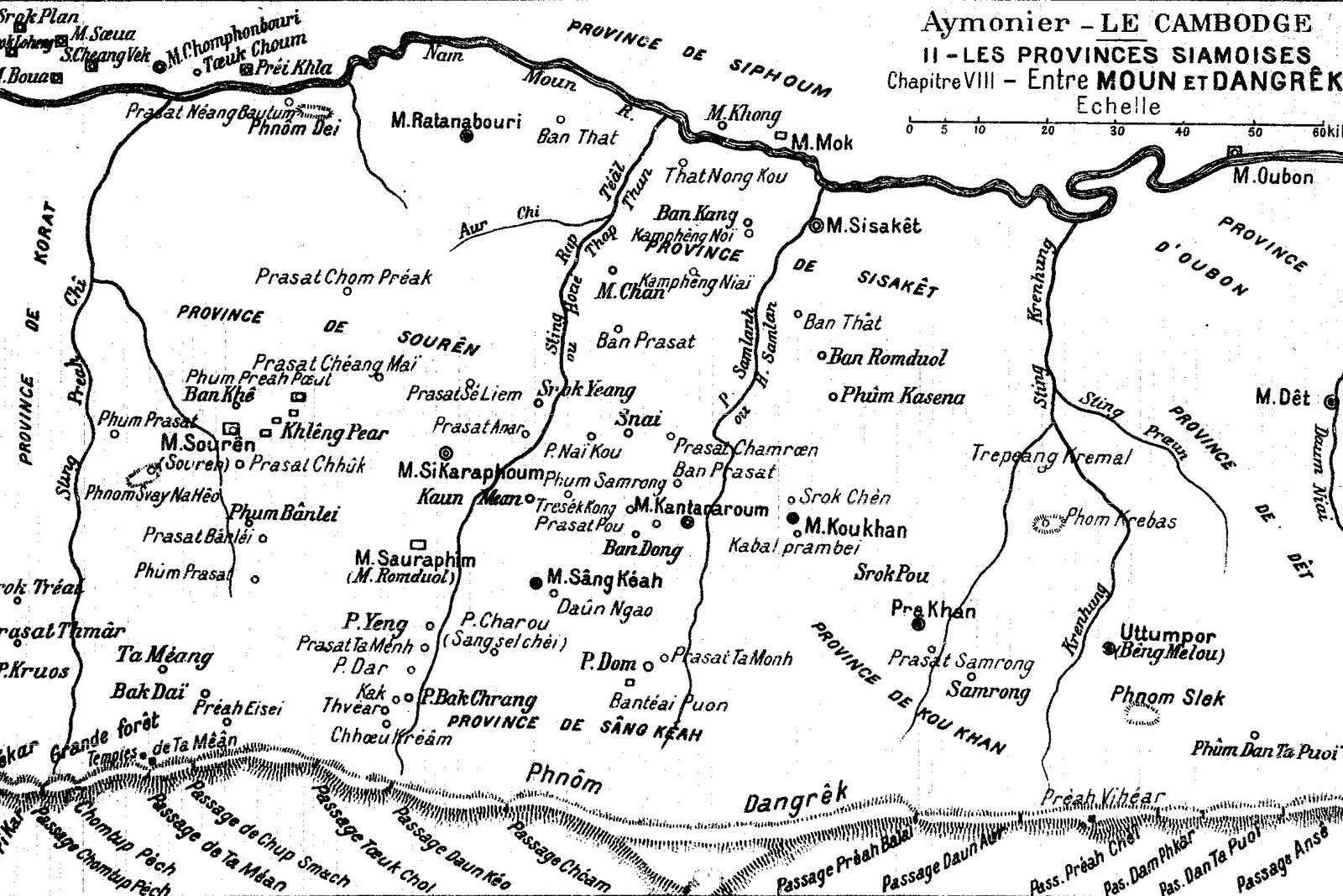
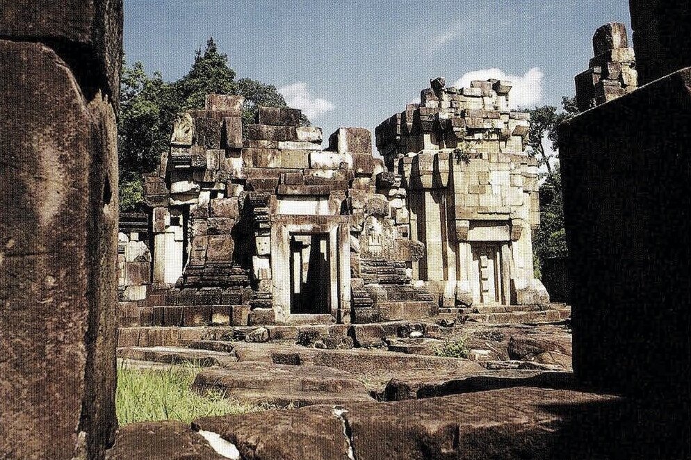
As for the group of Khmer temples south of the city of Surin near one of the main natural passes through the Dangrek rangethat triggered a bilateral crisis since November 2024, Etienne Aymonier, the first author to write extensively on them — and on Prasat Preah Vihear, incidentally — in 1910, defined them as the “most considerable ruins in Souren [Surin] province.” He didn’t specify that this group was on the Royal Road from Angkor and Banteay Chhmar to Phimai, a location later attested by several authors, including Coedès. AboutPrasat Ta Mean Thom ប្រាសាទតាមន្តធំ ปราสาทตาเมือนธม and Prasat Ta Moan Tauch, he noted
Ils sont construits à moins de deux lieues à I’Ouest du passage de Chup Smach, en terrain assez plat, à proximité de l’arête terminale de ce plateau, de cette faille brusque qu’on appelle les monts Dangrek et qui se dresse comme un mur de trois ou quatre cents mètres au nord du bassin du Grand Lac cambodgien. Ils sont a 1400 mètres l’un de l’autre, dans une foret déserte, silencieuse, qui couvre plusieurs lieues d’étendue et dont les gigantesques colonnades, qui supportent un sombre toit de vertes frondaisons, appartiennent en grande partie à l’espèce d’arbres que les Cambodgiens appellent “Pied de moineau”, essence incorruptible et durable entre tous les bois de fer du Cambodge.
Ta Mean Thom, le temple le plus oriental, à 600 mètres seulement de l’arête rocheuse, était annoncé, dès le pied des Dangrêk, par un escalier qui gravit le mont et qui sert encore aujourdhui de sentier aux bandits plutôt qu’aux très rares voyageurs qui osent pénétrer dans ces sotitudes. Les indigènes prétendent qu il y a au bas de cet escalier des statues d éiéphants et de crocodiles, mais le fait n’a pas été vérifié. L’escalier, atteignant le plateau supérieur, aboutit a une chaussée qui se dirige droit vers le perron d’accès du temple. Ce monument fait face au Sud. La pente du sol a nécessité une petiteterrasse dont le mur soutient la moitié méridionale de l’unique enceinte du monument.
Cette enceinte est une galerie rectangulaire mesurant 46 mètres N.-S. sur 38 mètres E.-O., construite en limonite et grès rose des Dangrek: ses murs hauts de trois mètres n’ont plus de toit. Quatre portes monumentales la décoraient à ses points de rencontre avec les axes l’édifice. De la porte du Sud partait une galerie d’axe de construction identique à cette galerie d’enceinte; elle conduisait droit au sanctuaire, grande tour de grès rouge, dont les quatre portes sculptées, faisant face aux points cardinaux, étaient flanquées de figures en haut relief: guerriers porteurs de massues ou gracieuses femmes tenant la fleur de lotus. En arrière de ce sanctuaire principal, deux autres tours assez bien conservées, hautes d’une douzaine de mètres, dépourvues de sculptures, présentaient la particularité, dont nous avons déjà vu des exemples, d’être entièrement construites en grès rouge à l’extérieur et en limonite à l’intérieur. Enfin, vers les angles en avant du sanctuaire s’élevaient deux édicules rectangulaires, aux murs droits, dépourvus actuellement de toiture et construits en limonite. Un bassin entièrement revêtu de limonite avait été creusé à quelque distance au Nord du temple. Il est à sec en fin de saison.
[They are built less than two leagues west of the Chup Smach Pass, on fairly flat ground, near the terminal ridge of this plateau, the abrupt fault called the Dangrek Mountains, which rises like a wall three or four hundred meters high north of the basin of the Great Cambodian Lake. They are 1,400 meters apart, in a deserted, silent forest, several leagues in extent, whose gigantic colonnades, supporting a dark roof of green foliage, belong largely to the species of trees that the Cambodians call “Sparrow’s Foot,” an incorruptible and durable species among all the ironwoods of Cambodia. Ta Mean Thom, the easternmost temple, only 600 meters from the rocky ridge, was announced, from the foot of the Dangrek Mountains, by a staircase that climbs the mountain and which still serves today as a path for bandits rather than for the very rare travelers who dare to penetrate these wildernesses. The natives claim that at the bottom of this staircase are statues of elephants and crocodiles, but this fact has not been verified. The staircase, reaching the upper plateau, ends at a causeway that leads directly to the temple’s access steps. This monument faces south. The slope of the ground necessitated a small terrace whose wall supports the southern half of the monument’s single enclosure.
Ta Mean Thom, the easternmost temple, only 600 meters from the rocky ridge, was announced, from the foot of the Dangrêk, by a staircase that climbs the mountain and which still serves today as a path for bandits rather than for the very rare travelers who dare penetrate these solitudes. The natives claim that at the bottom of this staircase there are statues of elephants and crocodiles, but the fact has not been verified. The staircase, reaching the upper plateau, ends at a causeway that leads straight to the access steps of the temple. This monument faces south. The slope of the ground required a small terrace whose wall supports the southern half of the only enclosure of the monument.
This enclosure is a rectangular gallery measuring 46 meters NW by 38 meters EW, built of limonite and pink Dangrek sandstone: its three-meter-high walls no longer have roofs. Four monumental gates decorated it at its meeting points with the axes of the building. From the southern gate started an axial gallery of identical construction to this enclosure gallery; it led straight to the sanctuary, a large red sandstone tower, whose four sculpted gates, facing the cardinal points, were flanked by figures in high relief: warriors carrying clubs or graceful women holding the lotus flower. Behind this main sanctuary, two other fairly well-preserved towers, about twelve meters high, devoid of sculptures, presented the particularity, of which we have already seen examples, of being entirely built of red sandstone on the outside and of limonite on the inside. Finally, towards the corners in front of the sanctuary rose two rectangular aedicules, with straight walls, currently without roofs and built of limonite. A basin entirely lined with limonite had been dug some distance to the north of the temple. It is dried up at the end of the season.
Prasat Ta Muan [Moan] Thom. Surin National Museum.
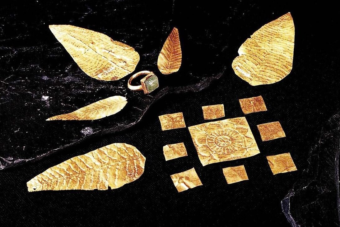
Leaf- and square-shaped gold plaques, gold ring. Khmer Art, Baphuon style (11th — 12th centuries A.D.) from Prasat Ta Muan Thom. Surin National Museum
Deux stèles ont été trouvées à Ta Mean Thom. L’une, placée à l’angle Sud-Est dans la galerie d’enceinte, est Une grande pierre plate de grès, préparée, polie, mais restée nue et attendant encore le ciseau du lapicide. L’autre, sous la porte monumentale de la face d’honneur de l’enceinte, est aussi une grande stèle plate qui dut, pour l’estampage, être déterrée de sous les décombres. Elle portait sur chacune de ses deux grandes faces une inscription khmère d’une vingtaine de lignes. La pierre, trop tendre, a tellement été rongée par le temps qu’on né peut plus y lire que des lettres Isolées, des mots épars ou de courts passages tels que ceux-ci: “…les gens qui sont là…pays…tous… offrir…le président.” Puis, après des formules imprécatoires, “…les chefs de la population… les chefs (de la cueillette de la cire) des abeilles…” Une liste nominative d’une quinzaine de “si” et de “tai” ou esclaves sacrés, est suivie d’une nouvelle formule imprécatoire. Sur la seconde face plus abimée encore que la précédente, on lit: “les autres biens sont aussi…pays…champs,” puis une autre liste nominative d’esclaves sacrés. L’écriture qui est tout à fait cursive né peut guère aider à dater le document. La langue, plutôt, permet de supposer qu’il remonte au Xeme siecel s’aka.
Ta Mean Tauch — Un sentier qui descend les Dàngrêk passé devant le temple de Ta Mean Tauch qui est beaucoup moins important que le précédent et qui est situé à 1400 mètres au delà dans la direction du Nord-Ouest, aussi en terrain plat, sous les arbres de la grande forêt. Un bassin profond, aux parois revêtues de limonite, mais qui assèche maintenant en fin de saison, avait été creusé à 10 mètres au Nord de ce temple qui regarde le soleil levant. Un mur d’enceinte de limonite, mesurant 30 mètres sur 20, haut de 2 mètres, était décoré, au milieu de la face orientale, d’une porte monumentale qui est l’unique issue du temple. Dans l’intérieur, on laisse à gauche l’édicule de limonite, aux murs hauts de 5 mètres, pour atteindre la tour ou sanctuaire qui était construite jusqu’aux deux tiers de sa hauteur (qui est d’une douzaine de mètres) en grès rouge semblable à celui du sous-sol local et en limonite au-dessus. Ce monument, classiquement simple, est dépourvu de sculptures et son état de conservation est passable.
La stèle parallélipipédique, qui a été déterrée sous la porte monumentale de son enceinte, tendrait, de même que cet état de conservation, à faire croire que Ta Mean Tauch a été édifté à une date plus récente que le monument voisin. Elle porte, sur ses quatre faces, 94 lignes au total d’une écriture de l’époque de Suryavarman II, XIeme siècle s’aka, mais moins belle, moins soignée que né l’est généralement l’écriture des Inscriptions de ce règne. Le document est entièrement sanscrit, les vers bien séparés en colonnes et les 47 strophes bien ponctuées, selon l’usage de ce temps-là. Généralement très lisible, malgré quelques éclats et une certaine usure de la pierre, il reste à étudier. On y lit les noms de Dharanindravarman et de Jayavarman, les deux prédécesseurs de Sûryavarman II. Le petit temple était probablement bouddhique: ce texte débutant par l’invocation Namovuddhaya, “hommage au Bouddha”.
[…] Prasat Ta Ménh est le nom donné à un ancien temple situé près du Sting Kap Téâl, à une lieue au Sud-Ouest du Phûm Yeng, dans les forêts clairières, sur un petit tertre entouré de plaines basses qu inondent les crues du torrent. Une première chaussée à l’Est courait parallèlement au torrent. Une autre levée de terre, carrée celle-ci, entourait un fossé plein d’eau et interrompu au milieu de sa face orientalepar l’avenue d’accès. Ce fossé entourait lui-même une seconde levée de terre. Au centre de ces carrés était creusé un petit bassin rond appelé Andaung Préng « puits antique, puits de la destinée » A une centaine de mètres vers l’Ouest, le temple, construit selon les dispositions les plus ordinaires de ces petits monuments, comprenait: un mur d’enceinte, de 20 mètres E.-O. sur 16 N.-S.; sa porte monumentale à l’Est; à l’intérieur l’édicule et la tour. Celle-ci, ruinée en partie, était construite moitié en grès, moitié en limonite; le reste du temple était en limonite On trouve encore, à moins de cent mètres au Sud de l’enceinte, une autre tour, en briques celle-ci, et deux petits bassins. [Le Cambodge: Les provinces siamoises, p 189 – 192]
[Two steles were found at Ta Mean Thom. One, placed at the southeast corner in the enclosure gallery, is a large flat sandstone stone, prepared, polished, but left bare and still awaiting the stonecutter’s chisel. The other, under the monumental door of the main face of the enclosure, is also a large flat stele which had to be dug out from under the rubble for stamping. It bore a Khmer inscription of about twenty lines on each of its two large faces. The stone, too soft, has been so eroded by time that one can now read only isolated letters, scattered words or short passages such as these: “…the people who are there…country…all…offer…the president.” Then, after imprecatory formulas, “…the leaders of the population… the leaders (of wax gathering) of the bees…” A nominal list of about fifteen “si” and “tai” or sacred slaves is followed by a new imprecatory formula. On the second side, even more damaged than the previous one, we read: “the other goods are also…country…fields,” then another nominal list of sacred slaves. The writing, which is entirely cursive, does little to help date the document. The language, rather, suggests that it dates back to the 10th century saka.
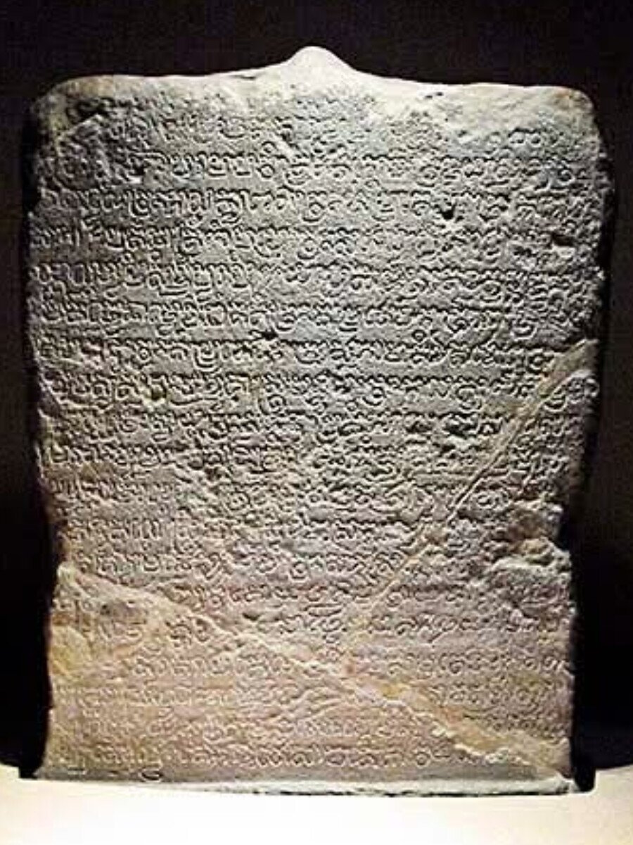
Stele bearing the inscription K. 1187, 10 or 11 th century. National Museum of Surin.
Stele bearing the inscription K. 1187, 10 or 11 th century. National Museum of Surin.
Ta Mean Tauch — A path descending the Dàngrêk passes in front of the temple of Ta Mean Tauch, which is much smaller than the previous one and is located 1,400 meters further northwest, also on flat ground, under the trees of the great forest. A deep basin, with walls lined with limonite, but which now dries up at the end of the season, had been dug 10 meters north of this temple which faces the rising sun. A surrounding wall of limonite, measuring 30 meters by 20, 2 meters high, was decorated, in the middle of the eastern face, with a monumental door which is the only exit from the temple. Inside, one leaves on the left the aedicule of limonite, with walls 5 meters high, to reach the tower or sanctuary which was built up to two-thirds of its height (which is about twelve meters) in red sandstone similar to that of the local subsoil and in limonite above. This monument, classically simple, is devoid of sculptures and its state of preservation is fair.
The parallelepipedal stele, which was unearthed under the monumental gate of its enclosure, would tend, as well as this state of preservation, to suggest that Ta Mean Tauch was built at a more recent date than the neighboring monument. It bears, on its four faces, 94 lines in total of a script from the time of Suryavarman II, 11th century saka, but less beautiful, less neat than the writing of the Inscriptions of this reign is generally. The document is entirely Sanskrit, the verses well separated into columns and the 47 stanzas well punctuated, according to the custom of that time. Generally very legible, despite some chips and some wear of the stone, it remains to be studied. One can read the names of Dharanindravarman and Jayavarman, the two predecessors of Sûryavarman II. The small temple was probably Buddhist: this text begins with the invocation Namovuddhaya, “homage to the Buddha.”
[…] Prasat Ta Ménh is the name given to an ancient temple located near Sting Kap Téâl, a league southwest of Phûm Yeng, in the clearing forests, on a small mound surrounded by low plains flooded by the torrent’s floodwaters. A first causeway to the east ran parallel to the torrent. Another earthwork, this one square, surrounded a ditch filled with water and interrupted in the middle of its eastern face by the access avenue. This ditch itself surrounded a second earthwork. In the center of these squares was dug a small round basin called Andaung Préng “ancient well, well of destiny.” About a hundred meters to the west, the temple, built according to the most ordinary layouts of these small monuments, included: a surrounding wall, 20 meters E.-W. on 16 N.-S.; its monumental door to the East; inside the aedicule and the tower. The latter, partly ruined, was built half in sandstone, half in limonite; the rest of the temple was in limonite. We still find, less than a hundred meters to the South of the enclosure, another tower, this one in brick, and two small basins. [Le Cambodge: Les provinces siamoises, p 189 – 192]
นำชมพิพิธภัณฑสถานแห่งชาติ สุรินทร์, สำนักพิพิธภัณฑสถานแห่งชาติ กรมศิลปากร กระทรวงวัฒนธรรม | Guide to Surin National Museum, The Fine Arts Department Ministry of Culture, 2007, 129 p. ISBN 978−974−425−056−8 [Thai, English]
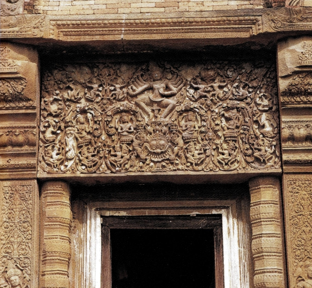
The Surin National Museum is graced with numerous pieces from Prasat Ta Moan Thom and Tauch, as well as a replica of the magnificent lintel “Shiva Nataraja”, door to the main sanctuary of Prasat Sikhoraphum ប្រាសាទសិខរៈភូមិ [ปราสาทศีขรภูมิ] (from Sanskrit sikhara, tower). Here is the original lintel in this temple dedicated to Shiva:
Shiva Nataraja, lintel from Prasat Sikhoraphum ប្រាសាទសិខរៈភូមិ ปราสาทศีขรภูมิ [photo Surin National Museum].
Shiva Nataraja, lintel from Prasat Sikhoraphum ប្រាសាទសិខរៈភូមិ ปราสาทศีขรภูมิ [photo Surin National Museum].
From the guidebook:
Much evidence exists of the flourishing civilization of Surin province in times past. Khmer culture monuments, found in many places throughout the province, provide the main evidence of this ancient civilization. These monuments were built of three primary materials: sandstone, laterite and ancient bricks. […] The Phanom Dong Rak mountain range separates Surin province from Cambodia, and there are several passes, including Chong Chom and Chong Ta Muan, through the mountains. During the 7 to 13 centuries, Khmer influence arrived in the northeast through these passes.
Pre-Angkorian Period: Khmer temples from the Chenla Period (7th century A.D.) have been found in Surin province, and statues of Harihara in the Phnom Da style (550−607 A.D.) were found in Phanom Dong Rak district. Stone inscriptions dating to the 7th- 8th centuries, which mention the ruler Chitrasena, were found at Wat Chumpon Sutthawas, Mueang district. The earliest Khmer temple, in the Prei Khmeng style (637 — 707 A.D.), is found at Ban Phumpon, Sangkha district. There is no more evidence of Khmer influence in Surin until the pre-Angkorian remains of the 10th century.
Angkorian Period: In the 9th century A.D., the Khmer established a new capital at Angkor in Siem Reap. Prasat Mueang Chai and Prasat Ban Chan in Sangkha district are Angkorian temples of this period, of the Koh Ker style (913 — 947 A.D.). A stone inscription dating to the reign of Rajendravarman (944 — 968 A.D.) mentions a temple and a curse against anyone damaging it. In the 11th and 12th centuries, at least twelve additional Khmer temples were built, including Prasat Tanong, Prasat Ban Phuang, Prasat Nang Bua Tum, Prasat Ta Muan Thom, Prasat Sikhoraphum, and probably the outer portion of Surin city. In the 13th century, during the reign of Jayavarman VII, other buildings were constructed, including travelers’ inns and hospitals, and the purpose of these buildings was mentioned in stone inscriptions. There are five hospitals and one traveler’s inn in Surin.
Jules Harmand on the 23 March 1907 French-Siamese Treaty
The tireless French explorer and colonial administrator, a pioneer in inscription stamping (at Wat Phu, a Khmer archaeological site now in Laos), had served as consul to the Kingdom of Siam (1883−1884), before holding the same post in Calcutta in 1885. His comments can be resumed as follows: A) by obtaining the restitution of the Batttambang and Siem Reap provinces to Cambodia, France guaranteed “the autonomy of Siam”; B) Cambodia was a “test bench” for a new version of colonialism, “Protectorate”, that France had never tested before, contrary to England; C) Giving back Krat peninsula to Siam was not such a big deal, considering that Angkor could then begin to be the cultural symbol of a “protected” Cambodia,under a strictly French supervision.
Excerpts:
A) Le Siam, la seule des royautés de quelque importance au delà du Gange qui ait réussi, en dehors de la Chine, à maintenir son indépendance contre les entreprises européennes, n’a survécu que grâce à notre arrivée sur le champ des compétitions extrême-orientales. Tous les Etats de l’ouest de l’lndo-Chine ayant succombé au contact britannique, il n’est pas douteux que, sans notre débarquement à Saïgon en 1859 et sans l’extension de notre-domination au Cambodge en 1863, le Siam eût été infailliblement englobé dans l’orbite conquérante de l’Angleterre dont il subissait déjà la puissante attraction. Si quelques enthousiastes irréfléchis ont cru possible de planter notre drapeau sur les rizieres et les pagodes du delta du Ménam, jamais aucun gouvernement français, ni aucun de ses agents responsables n’ont nourri une idée aussi chimérique: nos rivaux s’en rendaient pertinemment compte, tout en utilisant à leur profit les manifestations mégalomanes d’une presse ignorante. En réalité, nous avons toujours travaillé au maintien de l’autonomie du Siam; et c’est un succès méritoire d’y avoir réussi, en présence des forces supérieures de la Grande-Bretagne, s’appuyant sur une base commerciale alors incomparable, sur sa suprématie navale, sur son armée de l’Inde, et sur l’état divisé de l’Europe continentale. Je n’éprouve d’ailleurs aucune hésitation à reconnaître qu’il a fallu à nos voisins une sagesse supérieure et une modération exemplaire pour né pas céder à la tentation d’étendre la main sur une proie si riche, dont l’absorption n’eût soulevé après 1870 aucune difficulté insurmontable, surtout s’ils s’étaient contentés de l’établissement d’un de ces régimes de protectorat qu’ils excellent à graduer suivant les exigences de leur politique générale. C’est bien à nous que le Siam doit d’avoir traversé impunément une phase aussi critique. [p 87]
A) [“Siam, the only kingdom of any importance beyond the Ganges that has succeeded — aside from China — in maintaining its independence against European enterprise, survived only thanks to our arrival on the field of Far Eastern competition. All the states of western Indochina having succumbed to British contact, there is no doubt that, without our landing at Saigon in 1859 and without the extension of our domination to Cambodia in 1863, Siam would have been infallibly absorbed into the conquering orbit of England, whose powerful attraction it was already subject to. If a few thoughtless enthusiasts thought it possible to plant our flag on the rice paddies and pagodas of the Menam Delta, no French government, nor any of its responsible agents, ever entertained such a chimerical idea: our rivals were perfectly aware of this, while using to their own advantage the megalomaniacal manifestations of an ignorant press. In reality, we have always worked to maintain the autonomy of Siam; and it is a meritorious success to have succeeded in this, in the presence of the superior forces of Great Britain, relying on a then incomparable commercial base, on its naval supremacy, on its army in India, and on the divided state of continental Europe. I have no hesitation in acknowledging that our neighbors needed superior wisdom and exemplary moderation not to give in to the temptation to lay hands on such a rich prey, the absorption of which would not have raised any insurmountable difficulty after 1870, especially if they had been content with the establishment of one of those protectorate regimes which they excel at graduating according to the requirements of their general policy. It is indeed to us that Siam owes having gone through such a critical phase with impunity.”] [p 87]
B) Lorsque nous sommes arrivés en Cochinchine, nous avions désappris, depuis la fin du XVIIIeme siècle, toute pratique coloniale. Nous nous trouvions d’ailleurs en face d’un problème qui né s’était jamais posé à l’ancienne monarchie, car elle n’avait eu à gouverner que des colonies véritables, des « colonies à colons», et non pas à administrer des pays peuplés de grandes masses indigènes constituees en corps de nations. Notre administration coloniale métropolitaine né vivait que d’une vie bureaucratique précaire, sur les bribes de traditions assimilatrices héritées vaguement de l’ancien régime et né répondant pas aux besoins nou,veaux […] Nous n’eümes malheureusement pas l’idée, qui semble aujourd’hui naturelle, de jeter les regards autour de nous et de nous renseigner sur la pratique des Anglais dans l’Inde, où l’on rencontre toutes les formes possibles de protectorat, c’est-à-dire tous les degrés de rapports entre l’autorité britannique et les rajahs ou nababs feudataires ou médiatisés des “native states”. Nous attachant seulement à la préservation du pouvoir royal et à l’existence du monarque, nous perdions de vue les intérêts de son peuple lui-même, ignorans des responsabilités que nous allions assumer, et des calamités que cette omission allait bientôt répandre sur ce pays, dont nous avions pourtant la naïveté de nous considérer comme les bienfaiteurs. [p 89, 94]
B) [“When we arrived in Cochinchina, we had unlearnt all colonial practices since the end of the 18th century. We were, moreover, faced with a problem that had never arisen for the old monarchy, because it had only had to govern real colonies, “settler colonies,” and not to administer countries populated by large indigenous masses constituted as bodies of nations. Our metropolitan colonial administration lived only a precarious bureaucratic existence, on scraps of assimilatory traditions vaguely inherited from the old régime and not responding to new needs […] Unfortunately, we did not have the idea, which seems natural today, to look around us and find out about the methods of the English in India, where one encounters all possible forms of protectorate, that is to say, all the degrees of relations between the British authority and the feudal or mediatized rajahs or nabobs of the “native states”. Attaching ourselves only to the preservation of royal power and the existence of the monarch, we lost sight of the interests of its people themselves, ignorant of the responsibilities that we were about to assume, and of the calamities that this omission would soon spread over this country, of which we were nevertheless naïve enough to consider ourselves the benefactors.”] [p 89, 94]
C) Tout avantage se paie […] La rétrocession de Krat et des îles avoisinantes, mêlée à celle de Chantaboun, pourrait donner lieu à des observations d’une assez sérieuse portée. Elle est de nature à susciter des objections de la part des marins et des militaires. Toutefois, la propriété de toute la côte orientale du golfe de Siam, avec les nombreuses îles qui s’y trouvent disséminées, étant donné d’ailleurs notre supériorité navale sur le Siam, assure de ce côté à nos forces une sécurité aussi complète qu’il est possible de l’obtenir dans l’état général du monde. Il né dépend d’ailleurs que de nous de venir en aide à la nature au moyen de travaux de ports et de défense militaire appropriés à nos moyens et aux nécessités pratiques dûment étudiées et démontrées […] Je voudrais, en terminant, exprimer un voeu qui né saurait trouver une meilleure place qu’ici, et qui doit être dans la pensée des hommes cultivés de tous les pays, en voyant le plus magnifique groupe des monumens de l’ancien Cambodge, Angkor la Grande et Angkor la Sainte, passer sous notre garde effective. Retrouvés, explorés et étudiés par les Français, ils font en quelque sorte partie du patrimoine de notre orientalisme, et ont encore bien des réponses à donner à qui saura interroger leurs restes imposants. Mais nous leur devons aujourd’hui quelque chose de plus que l’attention des artistes et les recherches des savans: nous sommes préposés à leur conservation, et nous en devenons responsables devant l’humanité intelligente. Nous né devons pas rnanquer à ce devoir plus qu’aux autres. Nos corps savans, avec leur organe naturellement désigné, l’École Frariçaise d’ExtrêmeOrient, se préoccuperont des meilleurs moyens d’instituer la surveillance efficace et permanente de ces grandes archives de pierre, menacées par tant d’ennemis, et dont beaucoup ont déjà succombé sous les attaques du climat et de sa végétation dévorante, ou par suite de l’incurie et de la brutalité des hommes. [p 98, 102]
C) [“Every advantage comes at a price […] The retrocession of Krat and the surrounding islands, combined with that of Chantaboun, could give rise to observations of a fairly serious nature. It is likely to arouse objections from the Navy and the Army. However, ownership of the entire eastern coast of the Gulf of Siam, with the numerous islands scattered there, given our naval superiority over Siam, ensures our forces as complete security in this regard as is possible in the general state of the world. It is up to us to come to the aid of nature by means of port works and military defenses appropriate to our means and to the practical necessities duly studied and demonstrated […] I would like, in closing, to express a wish which could not find a better place than here, and which must be in the thoughts of cultivated men of all countries, seeing the most magnificent group of monuments of ancient Cambodia, Angkor the Great and Angkor the Holy, pass under our effective guard. Rediscovered, explored and studied by the French, they are in some way part of the heritage of our orientalism, and still have many answers to give to those who know how to question their imposing remains. But today we owe them something more than the attention of artists and the research of scholars: we are charged with their conservation, and we become responsible for it before intelligent humanity. We must not fail in this duty any more than others. Our learned bodies, with their naturally designated organ, the French School of the Far East, will concern themselves with the best means of establishing the effective and permanent watch over these great stone archives, threatened by so many enemies, and many of which have already succumbed under the attacks of the climate and its devouring vegetation, or as a result of the carelessness and brutality of men.”] [p 98, 102]
Further reading and research
Archaeologist and museum expert Michel Tranetis readying an exhaustive study on protohistoric and historic Khmer ceramics, particularly those found in locations now in Thai territories.
A missed opportunity: In 2008, Thai archaeologists were invited to join further research on Prasat Preah Vihear by Cambodia-based researchers. They declined, citing “unacceptable scientific inaccuracies in the content of the submitted documents” but failing to describe what those could have been: Office of Archaeology, Fine Arts Department Ministry of Culture and ICOMOS Thailand, Management Plan for Preah Vihear Mountain and Its Setting, 2551 B.E. (2008 AD.), 48 p.
Lt-Colonel Fernand Abraham Bernard (24 July 1866, Nîmes, France — 1st Aug. 1961, France) was a French colonial army officer from 1891 until his retirement on 5 Aug. 1908, an entrepreneur and businessman in Indochina and Java who helped to fund the French Resistance network Combat, and the leading negotiator in the Franco-Siamese discussions leading to the 23 March 1907 Treaty which gained the restitution of the provinces of Battambang and Siem Reap (thus Angkor) to Cambodia.
His elder brother Bernard Lazare (born Lazare Marcus Manassé Bernard, 14 June 1865- 1st Sept. 1903) was the libertarian journalist who helped author Emile Zola in breaking through the military censorship and publish his famous “J’accuse!” in defense against Captain Alfred Dreyfus, falsely accused of high treason in an antisemitic plot. Often called “the first Dreyfusard”, Lazare had published in 1894 the book Anti-Semitism, its History and Causes (L’Antisémitisme, son histoire et ses causes). Fernand Bernard never hid his Jewish origins and progressive views — his son Jean-Guy perished in the Auschiwtz concentration camp in July 1944, while his daughter Jacqueline barely survived deportation to Ravensbrück.
In 1906 – 1907, as the head of the French Delimitation Commission negotiating with the representatives of the King of Siam, he obtained the retrocession of Angkor, which he had often visited and photographed during his leave from active service. He published his recollection of the negotiations and his topographic work on the Siam-Cambodia borders in the bookA l’école des diplomates (1933). As a young colonial officer, however, he had no qualm in taking part in the brutal clampdown of peasant revolts, for instance the insurrection led by Ky Dong in Tonkin in 1897 – 8.
Lt-Colonel Bernard’s portrait in A l’école des diplomates.
Lt-Colonel Bernard’s portrait in A l’école des diplomates.
After a mission in Java at the turn of the century, Fernand Bernard spent most of his time as a civilian in French Indochina, becoming deputy director of the Messageries fluviales (Passenger and cargo transportation company along the Mekong River) in 1908 — president from 1925 until 1939, when he was evicted by the pro-Vichy administration. He carried on his research on infrastructure development in Laos, publishing in 1925 a study on transport routes in that country [“Les voies de communication au Laos”, L’Eveil économique de l’Indochine, n. 405, 15 March 1925].
He was involved in numerous commercial, agricultural and banking ventures: manager of tea and coffee plantations in Kontum (1925), rubber plantations in Memot (1926−1937), vice-president of the Union of Rubber Planters (1930), president of the Cigarette Manufactures of Indochina (1929−1939), director of Crédit foncier de l’Indochine (1923−1927) and Crédit hypothécaire de l’Indochine, director of the Loc-Ninh and Central-Indochina Railways (from 1929), as well as member of the board of director of Banque de l’Indochine from 1933 until 1956. He was made Grand-Officier de la Légion d’Honneur on 21 October 1932.
In 1945 (6−18 January), he joined the French delegation at the International Conference for Reconstruction held by the Institute of Pacific Ocean Relations in Hot Springs, USA.
Dong is an ancient Chinese term for a mountain valley community, especially in the southern and soutwestern regions abutting to 'historic' mainland China.
In Korea, dong동 has come to refer to a neighborhood or an administrative sub-district.
sk हरिहर harihara from हरि hari “bearing , carrying, one of the names of Vishnu” and हर hara "garland, necklace, one of the names of Shiva".
Harihara represents a syncretic form of Śiva and Viṣṇu. The fusional aspect of the deity derives from philosophical traditions in which Vishnu is said as being the shakti of Shiva, or Shiva is the one-who-knows (jñata) and Vishnu the knowledge (jñāna).
Harihara is often represented in the Khmer iconic tradition as four-armed, anthropomorphic form with the left side of the statue being Hari (Vishnu) with the cylindrical mitre (kirtamukuta), and the right Hara (Shiva) with the high crown of tangled locks (jatamukuta). It has been speculated that Harihara became a popular icon in the 7th-8th centuries as the rulers of the north ("Chenla"), followers of Shiva, wanted to ascertain their territorial aspirations and political aspirations over the south ("Funan"), where Vishnu was widely revered. Paul Lavy, however, argued that this explanation based on the assumption that Saivism and Visnavaism could have been rival sects in ancient Southeast Asia.
Hariharalaya ហរិហរាល័យ was the name of the pre-Angkor capital city founded by Jayavarman II at the end of the 8 th century in the Siem Reap area now called Roluos រលួស, the remains being the royal temples of Preah Ko, Bakong, and Lolei.